Downscaling Data
Temperatures
Compute downscaling coefficients
The source of the gridded temperature data mostly comes from a reanalysis which has a lower spatial resolution ranging from 0.25 to 2.5 degree. To get a gridded temperature data with a higher spatial resolution we need to downscale the data. Since the temperature varies with the altitude, the elevation data will be used to compute a constant lapse rates for each month. You can refer to the downscaling method CDT uses to compute the coefficients for temperature data for more details.
The color light blue of the menu means that you only need to compute the downscaling coefficients once. Indeed, you will need a long series and quality controlled station data to compute the coefficients. Once the coefficients are calculated you can use it to downscale the reanalysis data.
The menu allows to compute the downscaling coefficients for each month.
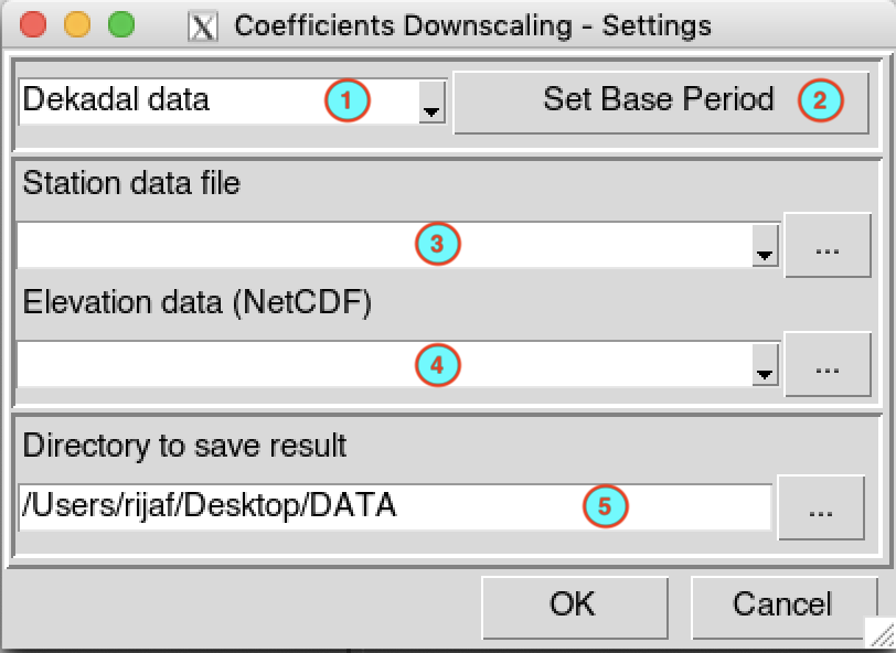
Select the temporal resolution of the input temperature data. Available temporal resolution are: daily, pentad, dekadal and monthly data.
Click on the button to specify the period and minimum number of year to be use to compute the coefficients. All the parameters can be set in the base period setting dialog.
Select the file containing the temperature data (in CDT station data format) to use from the drop down list if it is already loaded, or open it through
 .
.Provide the elevation data (netCDF format) to be used. Select it from the drop down list if it is already loaded, or open it through
.Type the full path to the folder to save the computed downscaling coefficients, or use the browse button
.
Click on the button  to
start the computation.
to
start the computation.
A folder named CoefDownTemp_<file name of station data> will be created under the folder you provided (5) to save the outputs. This folder contains two files:
- STN_DEM_GLM_COEF.rds: you will need this file when you are going to to downscale the reanalysis data.
- STN_DEM_GLM_COEF.txt: a text file containing the coefficients of the fitted linear regression (intercept and slope) for each month. See the downscaling method for further details.
Downscaling data
The menu allows to downscale the reanalysis data using the computed downscaling coefficients.
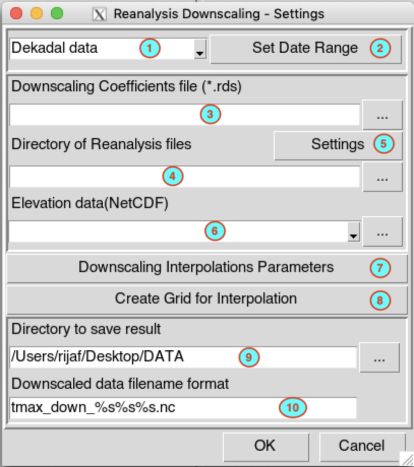
Select the temporal resolution of the input temperature data. Available temporal resolution are: daily, pentad, dekadal and monthly data.
Set the start and end date of the period over which the reanalysis data will be downscaled. See setting date range for more details.
Provide the full path to the file STN_DEM_GLM_COEF.rds containing the downscaling coefficients, or use the browse button
to open it.Type the full path to the folder containing the reanalysis data files (netCDF format) or browse it from the button
on the right.Provide a netCDF sample file and change the filename format of the netCDF file through the netCDF settings dialog by clicking on the button.
Provide the digital elevation model (DEM) data (netCDF format) to be used for the downscaling.
Click on the button to set the parameters of the interpolation. You can choose from 3 interpolation methods: inverse distance weighted, bilinear and ordinary kriging. See the interpolation dialog to select the method to be used and set the interpolation parameters; and spatial interpolation methods for further details.
Click on the button to provide the grid to be used to interpolate the data. It will display the grid creation dialog box.
Type the full path to the folder to save the downscaled temperature data, or use the browse button
.Specify the netCDF filename format of the output files.
Click on the button to
start the downscaling.
A folder named Downscaled_Reanalysis__<start date>_<end date> will be created under the folder you provided in (9) to save the outputs. It contains the downscaled temperature data in netCDF format.