Regrid Spatial Data
The menu allows to perform a spatial regridding of netCDF datasets. You can change the grid resolution and extent of the input data to a different grid resolution.
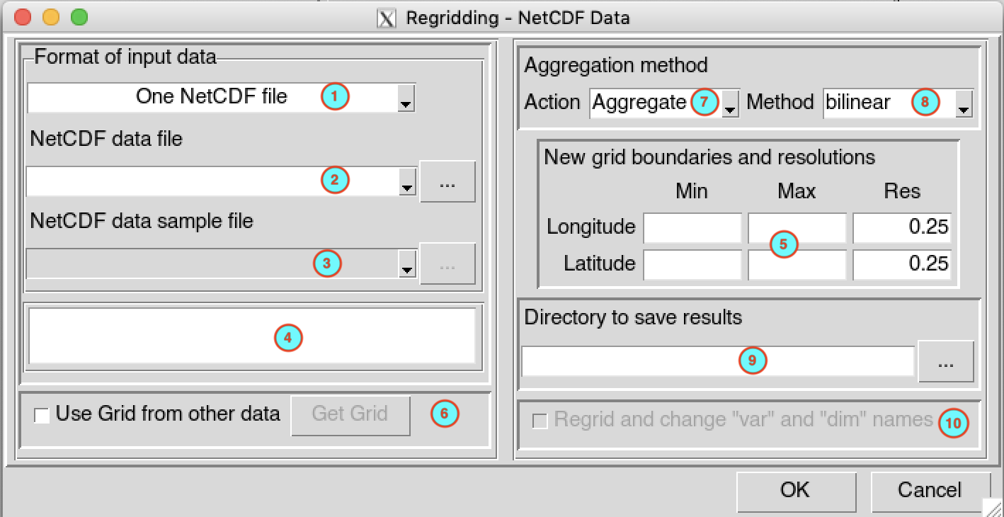
Select the format of the input data to regrid. Available data formats are: One NetCDF file, Multiple NetCDF files or CDT Gridded Dataset Format.
If the input data is a One NetCDF file, select from the drop-down list the netCDF file if it is already loaded, or open it from the browse button
 on the right. If the input data is
a Multiple NetCDF files, type the full path to
the folder containing the netCDF files or browse it. In case of
CDT Gridded Dataset Format, browse the index
file of the CDT dataset from the button on the right.
on the right. If the input data is
a Multiple NetCDF files, type the full path to
the folder containing the netCDF files or browse it. In case of
CDT Gridded Dataset Format, browse the index
file of the CDT dataset from the button on the right.If you regrid a Multiple NetCDF files, this input field will be activated allowing you to provide a netCDF sample file. Select from the drop-down list the netCDF file if it is already loaded, or open it from the browse button
.The bounding box (minimum/maximum longitude/latitude) and the resolution of the data will be displayed in this area.
Specify here the bounding box and resolution of the new grid. The values of the minimum/maximum for longitude/latitude are set here by default. These input fields are deactivated when (6) is checked.
Check this box if you want to get the grid for the regridding from other data source. If checked, the button is activated and (5) are deactivated, allowing you to provide the new grid through a dialog box.
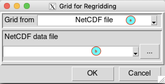
- (a) Select the data source you want to get the new grid. Available options are: NetCDF file or CDT Gridded Dataset Format.
- (b) If the source is from a NetCDF
file, select from the drop-down list the netCDF file if it
is already loaded, or open it from the browse button on the right. In case of
CDT Gridded Dataset Format, enter the full
path to the index file of the CDT dataset or browse it from the button
on the right.
Select the regridding method to use. Valid options:
- Aggregate: regrid data from high resolution into low resolution.
- Disaggregate: regrid data from low resolution into high resolution. Spatial disaggregation should be used and interpreted with the utmost caution. No additional information other than what is already contained in the original data is obtained.
In case of aggregation, if you set yourself the new grid, two methods are available: mean and bilinear interpolation. The mean method consist in averaging the values from the old grid points which are included in the new grid point. This method is usually used to aggregate elevation data from a high resolution Digital Elevation Model. If you use a grid points from other data source (6 checked), the bilinear method only is available. For disaggregation, only the bilinear method is available.
Type the full path to the folder to save the regridded data or browse it.
If (6) is checked, check this box if you want to change the names of the variable and dimensions of the regridded netCDF or CDT Gridded datasets to be the same as the input data.
Click on the button  to
regrid the data.
to
regrid the data.
The regridded data are saved in a new folder named Regrided_Data under the folder you provided to save the output in (9).