October Climate Briefing: El Niño Wait Continues
From the October climate briefing, given by IRI’s Chief Forecaster Tony Barnston:
Tony Barnston provides an overview of the briefing
Changes from last month’s briefing
Based on the latest models, the chance of an El Niño developing during the current (October-December) season is between 65 and 70%, down slightly from last month. These odds for the October-December season are similar to those issued by the NOAA Climate Prediction Center/IRI forecast issued on October 9, but the updated forecast issued this week calls for the chance of El Niño to stay at this level until the March-May 2015 season.
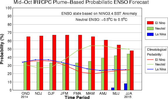
The IRI/CPC probabilistic ENSO forecast issued mid-October 2014. Note that bars indicate likelihood of El Niño occurring, not its potential strength. Unlike the official ENSO forecast issued at the beginning of each month, IRI and CPC issue this updated forecast based solely on model outputs. The official forecast, available at http://1.usa.gov/1j9gA8b, incorporates human judgement.
El Niño conditions usually do not last beyond the boreal spring, so continuation of El Niño into June would be unusual. It is not unheard of, however; an El Niño event that began in early autumn of 1986 lasted to the early months of 1988. Barston said it is much to early to say with any confidence whether such an event could happen this time.
Surface and subsurface heat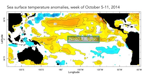
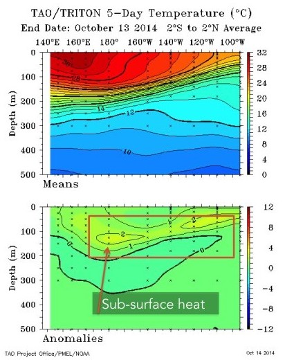
Image modified from NOAA TAO Project.
For the past several months, models have predicted El Niño to form in the immediate future. Although there have been periods during this time of up to a few weeks in which sea surface temperatures in the Nino3.4 area have been around 0.5ºC above average, the coupling action required by the atmosphere has not been established, and the sea surface temperatures have intermittently cooled. For an El Niño event to be officially established, the 3-month average of sea surface temperatures in the Nino3.4 region must be at least 0.5ºC above normal for five continuous overlapping 3-month seasons (i.e., about 7 months).
As can be seen in the image above, the areas to the west and east of Nino3.4 are experiencing warmer sea surface temperatures than the Nino3.4 area. This may be preventing a pressure differential from creating the atmospheric conditions necessary to sustain El Niño conditions. Nevertheless, there is still subsurface heat that could make its way to the surface (see TAO image). Barnston said this may be why models are continuing to call for El Niño odds above 60%.
Effects of El Niño on global seasonal forecasts
 Each month, IRI issues seasonal climate forecasts for the entire globe. These forecasts take into account the latest ENSO projections and indicate which areas are more likely to see above or below normal temperatures and rainfall. Although an El Niño has yet to develop, the climate impacts are still expected to resemble those of a weak to moderate El Niño. For the December-February period, when the potential El Niño is predicted to be at its strongest, the forecast continues to show a strong likelihood of drier than normal conditions over Indonesia and a moderate likelihood of drier conditions in Central America (image right). Wetter-than-average conditions are still expected over southeastern South America later this year.
Scientists should know more each month about the chances for El Niño, its potential strength, and the climate impacts. Sign up here to get notified when the next forecast is issued, and in the meantime, check out #IRIforecast or use #ENSOQandA on Twitter to ask your El Niño questions.
Forecast in Brief
Download a PDF summary of the August 2014 IRI Climate Briefing
You must be logged in to post a comment.