September Climate Briefing: Weak El Niño Still Favored Forecast
From the September climate briefing, given by IRI’s Chief Forecaster Tony Barnston:
Changes from last month’s briefing
Based on the latest models, the chance of an El Niño developing during the September-November season is 55%, which is the same as the forecast for the same period that was issued in August. The probability for El Niño development by the late months of 2014, however, remains at 70-75%, similar to the forecasts released the past few months. This El Niño forecast for late 2014 is slightly higher than the NOAA Climate Prediction Center/IRI forecast issued on September 4.
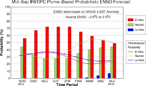
The IRI/CPC probabilistic ENSO forecast issued mid-September 2014. Note that bars indicate likelihood of El Niño occurring, not its potential strength. Unlike the official ENSO forecast issued at the beginning of each month, IRI and CPC issue this updated forecast based solely on model outputs. The official forecast, available at http://1.usa.gov/1j9gA8b, also incorporates human judgement.
El Niño Conditions vs. El Niño Events
If an El Niño is going to materialize, it will almost certainly do so in the next month. Most models indicate that a weak El Niño will develop, though some indicate a moderate event and some no event. In the week leading up to the September briefing, increasing warming was observed in the Nino3.4 area of the equatorial Pacific Ocean. Barnston says this warming is consistent with a budding El Niño, though it is still too early to confirm. These above-average temperatures are in fact not warmer than those seen in June, but the atmospheric conditions needed to engage the coupled ocean-atmosphere phenomenon of El Niño were not present earlier this year. Surface waters therefore cooled during late July and much of August.
Barnston says the difference now is that at this time of year – early autumn in the Northern Hemisphere – conditions tend to persist for the next several months, so it is more likely the warmer sea surface temperatures will remain. Further, the atmosphere is also now presenting conditions consistent with El Niño. The 30-day average of the Southern Oscillation Index, which measures the pressure differential between Tahiti and Darwin, Australia, was -10 in the week leading up to the climate briefing. An SOI value sustained below -8 is considered to indicate an El Niño may be present.
As alluded to above, however, the presence of warming in the Pacific and a negative Southern Oscillation Index do not on their own constitute an El Niño condition. Such observations must persist for generally one calendar month for NOAA and IRI scientists to declare that an El Niño event has officially arrived. Even then, an El Niño episode does not go on the books in the U.S. until the 3-month average of sea surface temperatures in Nino3.4 are at least 0.5ºC above normal for five continuous overlapping 3-month seasons (i.e., about 7 months).
Effects of El Niño on global seasonal forecasts
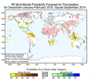
Each month, IRI issues seasonal climate forecasts for the entire globe. These forecasts take into account the latest ENSO projections and indicate which areas are more likely to see above or below normal temperatures and rainfall.
Although an El Niño has yet to develop, the climate impacts are still expected to resemble those of a weak to moderate El Niño. For the December-February period, when the potential El Niño is predicted to be at its strongest, the forecast shows a likelihood of drier than normal conditions over Indonesia, northern South America and southern Africa (image right). Wetter-than-average conditions are expected over southeastern South America and the southern United States later this year.
Scientists should know more each month about the chances for El Niño, its potential strength, and the climate impacts. Sign up here to get notified when the next forecast is issued, and in the meantime, check out #IRIforecast or use #ENSOQandA on Twitter to ask your El Niño questions.
You must be logged in to post a comment.