March 2014 Climate Briefing: Increasing Odds for El Niño
From the March climate briefing, given by IRI’s Chief Forecaster Tony Barnston:
Tony Barnston provides an overview of the briefing
Changes from last month’s briefing
The IRI’s March ENSO forecast puts the chances of El Niño conditions at 60% for early next fall, an increase from the 45% probability in IRI’s February forecast and the 52% probability from NOAA/IRI’s official prediction issued on March 6. Temperatures below the surface of the central Pacific Ocean are warmer than average as a result of Kelvin waves moving across the Pacific. For an El Niño to form, however, temperatures at the surface in this area must also warm. The current uncertainty around El Niño developing is based on whether this surface warming plays out. “We cannot, at this time, accurately determine how strong an El Niño might be, even if one does form,” Barnston says.
Effects of possible El Niño on global seasonal climate forecasts
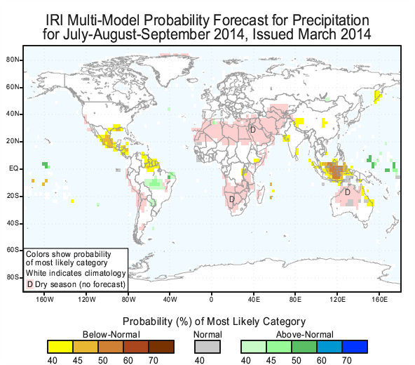
Each month, IRI issues seasonal climate forecasts for the entire globe. These forecasts, which take into account the latest ENSO projections, indicate which areas are more likely to see above or below normal temperatures and rainfall. Right now, the forecasts are only showing weak impact to climate in areas typically influenced by El Niño (the forecast for July, August and September is pictured at right, all of the seasonal forecasts are available here). Such impacts include an increased chance for below average rainfall in Indonesia and an increased chance for above average rainfall in central Brazil.
Scientists should know more each month about the chances for El Niño, its potential strength, and the climate impacts. Sign up here to get notified when the next forecast is issued, and in the meantime, check out #IRIforecast or use #ENSOQandA on Twitter to ask your El Niño questions.
You must be logged in to post a comment.