IRI @ AMS: Schedule of Events
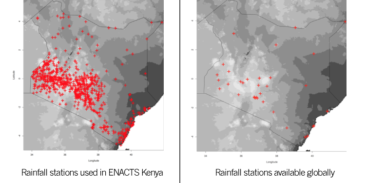
“Observations Lead the Way” is the theme for the upcoming 97th annual meeting of the American Meteorological Society. Much, if not all, of the initiatives at the International Research Institute for Climate and Society rely on a critical mass of quality weather and climate observations. The presentations of IRI’s staff and scientists at this year’s AMS meeting reflect this dependence, the most direct of which comes from Tufa Dinku. In his talk, Dinku will explain the implications of the Enhancing National Climate Services (ENACTS) initiative for decision making. ENACTS uses a combination of ground-based observations (i.e. weather station data) and satellite observations to produce a climate dataset more robust than any globally-available dataset. Dinku also has a poster on validating the rainfall estimates from one of these global datasets. Other presentations narrow in on specific diseases — malaria and the Zika virus — that are sensitive to changes in climate. These talks, along with a presentation from Andrew Kruczkiewicz on preparedness actions based on flood forecasts, are part of a session co-hosted by IRI.
A poster from Asher Siebert will dive into one of the ENACTS countries, Rwanda, and see what new climate knowledge can be gleaned from the ENACTS-improved dataset. A talk from Elisabeth Gawthrop will detail efforts to use a different sort of observation — media mentions of El Niño — to better understand what influences press coverage of climate in Kenya. IRI’s presentations will end with a talk from Hannah Nissan on heat waves in Bangladesh.
More details for each activity are below, with links to the conference program.
Town Hall Meeting: Challenges, Opportunities and Advances in Global Flood Forecasting
Andrew Kruczkiewicz, IRI/Red Cross Red Crescent Climate Centre, Panelist
This town hall will discuss innovative methods for flood and flash flood prediction focused on systems and methods applied at global scale. Advancements in computing power have recently enabled distributed hydrologic models to be run at 1-10 km2 spatial resolution over the world with forecast lead times up to a week. These hydrologic models are commonly forced with satellite-based rainfall or output from numerical weather prediction models. The discussion will focus on the current state of global hydrologic forecasting systems and how these systems are envisioned to evolve into the future with an emphasis on the Global Flood Partnership (GFP).
Poster: Climatology analysis from a new multi-decade high-resolution rainfall and temperature dataset for Rwanda
Asher Siebert, IRI, Presenter
& T. Dinku, F. Vuguziga, M. M. Mbati, J. M. V. Niyitegeka, S. J. Mason, and A. W. Robertson
Meteorological station coverage over the nation of Rwanda dropped dramatically in the mid-1990s following the 1994 genocide, which was a factor for the decline in meteorological station coverage, and remained limited for years afterwards and has only recently begun to rebound. The ENACTS (Enhancing National Climate Services) initiative implemented in Rwanda has reconstructed rainfall and temperature data by combining station data with satellite rainfall estimates for rainfall, and with reanalysis products for temperature. The generated datasets covers the period from the early 1980s to the present and are available at spatial resolutions of 5km. Due to the nation’s highly varied topography and East Africa’s complex meteorology, there is considerable spatial heterogeneity in rainfall. This paper will explore the temperature and rainfall climatology of Rwanda using this new dataset, with particular focus on the variability of the March-May and September-December rainy seasons at high spatial resolution. Read the rest of the abstract.
Presentation: Integrating Satellite Rainfall Estimates and Ground Observations to Enhance Climate Services in Africa
Tufa Dinku, IRI, Presenter
Climate observation networks in many parts of Africa face many challenges that limit the ability to provide even the most basic of climate information for informing development. The International Research Institute for Climate and Society, in collaboration with the national meteorological agencies and regional climate centers, has been leading an effort to simultaneously improve the availability, access and use of climate information at national level. This effort, named Enhancing National Climate Services (ENACTS), focuses on the creation of reliable climate information that is suitable for national and local decision-making. Satellite rainfall estimates are critical inputs for reconstructing historical rainfall time series going back over 30 years. The main advantage of the satellite products is the excellent spatial coverage at increasingly improved spatial and temporal resolutions. Read the rest of the abstract.
Poster: El Niño and Malaria in Eastern Africa: The Ethiopian Experience and Recent Advances in Data and Tools
Aisha Sekelaga Owusu*, IRI; and A. Woyessa, R. Cousin, T. Dinku, D. Korecha, A. G. Barnston, B. Lyon, M. Thomson, and A. Kebe
A review of the published and grey literature was conducted to identify epidemic/outbreak events and their temporal and spatial characteristics in Ethiopia for the period 1951-2014. The timing and geographic locations (where known) of the observed epidemics were then associated with their respective ENSO phases (El Niño, Neutral or La Niña) using the ONI SST index for El Niño 3.4. In order to account for the delayed impact of changes in SST on ambient air temperature, the SST analysis was lagged by 3 months. In addition, a detailed analysis of the spatial and temporal impact of ENSO on temperature and rainfall for the periods of 1981-2014 and 1983-2014, respectively, was undertaken using high resolution climate data made available through the Enhancing National Climate Services (ENACTS) initiative implemented at the Ethiopian National Meteorological Agency. Read the rest of the abstract.
Poster: ENACTS Training Manuals for the East African Health Community
Aisha Sekelaga Owusu*, IRI; and M. Thomson, P. Ceccato, T. Dinku, I. Khomyakov, J. del Corral, and Y. Tesfamariam Tekeste
Through the support of the UK Department for International Development (DFiD) WISER ENACTS, International Research Institute for Climate and Society (IRI), in conjunction with the East African NMHS and public health partners, have begun fill the gaps existing in climate and health knowledge and practice, by developing core ENACTS training manuals. Currently these training manuals focus on specific ENACTS products within each countries’ Maprooms and subsequent Mapages to assist in the understanding the role that past and present climate and climate variability can have in sound public health decisions.
The training manuals are designed for those in the public health community with little to no prior knowledge of climate science. Read the rest of the abstract.
*Madeleine Thomson will be representing Aisha Owusu at AMS
Session: Using Climate Information Services to Support the Global Health Community
Cochairs: Joy Guillemot, WMO, WMO/WHO Climate and Health Office, Geneva, and Madeleine Thomson, IRI
Session jointly hosted between the Eighth Conference on Environment and Health; and the Seventh Conference on Transition of Research to Operations
The purpose of the session is to emphasize the importance of using climate information and services to understand and manage climate sensitive health risks, support health delivery, and improve outcomes. Research is invited that highlights how, by working with regional and national partners, data, technology, and training may be utilized to strengthen health policy and practice in the context of a changing climate in Asia, Africa or South America-Caribbean.
Presentation: Triggering Health Relative Preparedness Action Based on Meteorological and Climatic Forecasts
Andrew Kruczkiewicz, IRI/Red Cross Red Crescent Climate Centre, Presenter
& E. Coughlan de Perez, C. Jaime, and P. Suarez
Forecast based financing (FbF) is a novel approach to climate services. FbF refers to the automatic triggering of pre-established humanitarian actions based on forecasts and observations at various lead times (Coughlan de Perez et al., 2015). This system will be of particular interest to humanitarian and government disaster managers as preparedness actions prior to hydro-meteorological disasters can be ad hoc. Read the rest of the abstract.
Presentation: Enhancing National Climate Services to Support Climate-Sensitive Health Decisions in Africa
Tufa Dinku, IRI, Presenter
It is disconcerting to note that climate information is not widely used in Africa to make development decisions. This is mainly because useful information is often not available or, if it does exist, is inaccessible to those that need it most. The International Research Institute for Climate and Society (IRI), in collaboration with National Meteorological and Hydrological Services (NMHS) and other partners, has been leading an ambitious effort to simultaneously improve the availability, access and use of climate information at the national level. The Enhancing National Climate Services (ENACTS) initiative focuses on enabling NMHS to create reliable climate information that is suitable for national and local decision-making. Read the rest of the abstract.
Presentation: Increasing Elevation of the Temperature Constraint on Malaria Transmission in the Ethiopian Highlands
Bradfield Lyon, University of Maine, Orono, ME, Presenter
& T. Dinku and M. Thomson
Lower temperatures in the Highlands of East Africa have historically offerred an altitudinal constraint on the transmission of malaria. A warming climate, however, will serve to increase the elevation at which this constraint applies. Using a new climatological dataset that calibrates and combines inferred temperatures from satellites with numerous station observations the elevation at which the constraint holds has been analyzed for the country of Ethiopia over the period 1982-2014. The results show that in a given year there are substantial spatial variations in the elevation where the temperature constraint holds, which is shown to be associated with the relative orientation of orography to the prevailing winds (e.g., upslope and downslope flow patterns). On interannual timescales there is also a substantial contribution to elevation changes… Read the rest of the abstract.
Presentation: Towards a ZIKV Climate-Health Service at the Latin American Observatory
Ángel G. Muñoz, GFDL, Princeton, NJ; & M. Thomson, X. Chourio, A. M. Stewart-Ibarra, P. Najera, and R. Cousin
*Madeleine Thomson will be giving this presentation on behalf of Ángel Muñoz
Using the Datoteca, a local branch of the International Research Institute for Climate and Society’s (IRI) Data Library, the Latin American Observatory is developing a web service that (a) fully considers the contribution of climate as a partial driver of the the Zika virus seasonality, (b) uses the most updated health and socio-economic information relevant to the problem, and (c) integrates these different components in an action-oriented, easy-to-use and freely-available online interface that permits the users to assess both present and expected conditions that could affect ZIKV-sensitive populations in the Americas. Here we introduce and discuss the first version of this novel climate-health service, available —in Spanish— at http://datoteca.ole2.org/maproom/Sala_de_Salud-Clima/index.html.es. Read the rest of the abstract.
Presentation: Media Analysis: Communication of the 2015/16 El Niño within Kenyan Media
Elisabeth Gawthrop, IRI, Presenter
& D. J. Farnham, F. Fiondella, A. S. Owusu, M. Thomson, F. Percy, W. Chung, and K. McKeown
The 2015/2016 El Niño has provided an unprecedented opportunity to analyze the dissemination of specific climate event information from a range of providers, its potential, and realized impacts. In this effort, the International Research Institute for Climate and Society (IRI) has partnered with the Columbia University Data Science Institute (DSI) and CARE/ALP of Kenya to evaluate El Niño references in social media and local media analysis. Read the rest of the abstract.
Presentation: Heat health in Bangladesh: defining and predicting heat waves across timescales
Hannah Nissan, IRI, Presenter
& K. G. Burkart and S. J. Mason
Reliable forecasts are an essential building block of an effective early warning system. These are needed at a sufficient lead time to enable preparatory action to be taken in advance of a heat wave. Yet good forecasts are not possible without a solid understanding of the occurrence and behavior of heat waves, and so far there has been little research in this area for South Asia. This study focuses on Bangladesh, one of the most motivated countries in the region in this regard. The presentation will examine the physical characteristics of heat waves in Bangladesh, exploring the roles of synoptic dynamics, the land surface and variability in the global oceans as drivers of these events. Results suggests that opportunities exist for extended range prediction of heat waves in Bangladesh, offering the potential to provide more advance warning and increasing the capacity to prepare. Read the rest of the abstract.
Poster: Validation of CHIRP Satellite Rainfall Estimates
Tufa Dinku, IRI, Presenter
The quality and temporal/spatial resolution of satellite rainfall products has been improving over time. One of the factors that contributed to their improvement has been the use of passive microwave data. However, this use of passive microwave data may have also introduced inhomogeneities in the rainfall time series due to changes in the numbers sensors over the years. In parallel to these products, there is also a need for historical rainfall time series derived from a single sensor (i.e., infrared sensors). Such products do exist (e.g. ARC and TAMSAT), but are limited in terms geographical coverage. There is now a new product from the Climate Hazard Group at University of California, Santa Barbara. The CHIRP (Climate Hazard Group Infrared Precipitation) product goes back to 1981 and is available at pentad and dekadal time scales and spatial resolution of 0.5deg. CHIRP has been validated over eastern Africa,. The results of this validation work will be presented.
You must be logged in to post a comment.