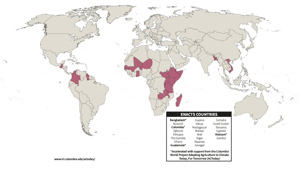
Colombia, Guatemala adopt ENACTS Climate Data Initiative
The Adapting Agriculture to Climate Today, for Tomorrow Columbia World Project is working with the governments of Colombia and Guatemala to implement a climate data initiative called Enhancing National Climate Services, or ENACTS, to help them better integrate climate knowledge into national-level planning and policy.
Since 2014, ENACTS has helped countries facilitate the integration of climate knowledge into national-level decision making by improving the availability, access to, and use of climate information. Many developing countries often have significant gaps in their historical climate records, which are compiled from ground-based weather observations. Funding and resource constraints and military conflict are two reasons for these gaps. Furthermore, operational weather stations may not be evenly distributed throughout a country, leaving significant areas without local weather and climate data. ENACTS helps address this problem by combining the ground-based records with satellite weather data, as well as data from climate models. The result is a richer, higher quality climate dataset that can be used to improve climate analysis and forecasting for an entire country.
The national meteorological services of Bangladesh, Ethiopia, Ghana, Guyana, Kenya, Madagascar, Mali, Rwanda, Senegal, Tanzania, and Zambia have benefited from the climate mapping and analysis tools they have co-developed with IRI’s ENACTS team. In the last few years, these efforts have been accelerated by the Columbia World Projects’ Adapting Agriculture to Climate Today, for Tomorrow (ACToday), which has focused on building models for the use of the next generation of forecasting (NextGen) in the countries where it operates.

Recently, Colombia and Guatemala joined the ranks of countries using ENACTS-based data, guided by IRI data scientist Xandre Chourio. To better understand how ENACTS development unfolded in both Latin American countries, we asked Chourio to answer a few questions about this work.
Tell us a bit about the products that have been produced in this initial stage. How will they be used by the national meteorological services of Colombia and Guatemala (IDEAM and INSIVUMEH, respectively)? What do you think the benefits will be?
At the moment, we have gridded data for 30 years of precipitation and temperatures (maximum, mean, and minimum) for Guatemala and Colombia. The precipitation product is ready to use, and temperatures are now in the final verification process by local experts of INSIVUMEH and IDEAM. The implementation of the ENACTS methodology has increased the capacity of those institutions to improve other existing products in their countries. For example, they are now in the process of linking their NextGen forecast systems to ENACTS, which will help provide quality climate information and services to other important sectors, as agriculture, water resources, energy, and risk management.
IRI has been working with IDEAM and INSIVUMEH for many years now. How has that long term relationship played a role in producing ENACTS-based data with these institutions?
There are several factors that are key to the success of any product, and probably by far the most important one is trust between the involved partners and agreement on how the methodology will be implemented. Because of their now decades-long relationship with the IRI, we were able to work together with IDEAM and INSIVUMEH in a more expeditious way to produce the ENACTS data, even during the present COVID pandemic. These two agencies have been crucial and enthusiastic partners in the IRI-led ACToday project on climate and food security.

Photo: Jacquelyn Turner/IRI.
How has the COVID-19 pandemic affected this implementation?
The best way to implement the ENACTS methodology (from software installation to training and operationalization efforts) is to work in a face-to-face synchronous way with the team of each institution. However, the restrictions applied by COVID-19 made this option impossible. It has been an extremely difficult challenge to complete ENACTS through teleworking, especially considering the extra workload activities of each participant due to COVID19, along with additional issues related to access to the original in-paper data, which was physically at the national meteorological services while people were working from their homes. A key element for the success of the ENACTS implementation has been the adapting capacity and the level of engagement of each participant in both institutes, which allows for the local capacity enhancement of INSIVUMEH and IDEAM.
What do you see as the next steps with this process, especially regarding how ENACTS helps with the embedding of climate services?
As we mentioned, the first immediate step will be to use ENACTS as input for the NextGen climate forecast system co-developed with INSIVUMEH and IDEAM. Additionally, these data sets will be available at the IRI’s and INSIVUMEH’s Data Libraries to be available for the public use. A benefit of ENACTS is that it is a dynamic: both institutions will continue using the ENACTS process to provide new versions of the products with new stations and increasing the data time period available for it, guaranteeing the sustainability of ENACTS in these countries.

You must be logged in to post a comment.