Interns Explore Epidemic, Crop Yield Predictions for IRI, NASA
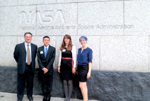
IRI Research Scientist Pietro Ceccato and DEVELOP interns Sunny Ng, Elisabeth Gawthrop and Caitlin Reid at NASA’s Washington, D.C. headquarters where Ng, Gawthrop and Reid presented their projects for the DEVELOP program’s annual closeout event.
Andrew Kruczkiewicz sits in front of his laptop, examining a map of South Sudan. The map shows precipitation across the country in varying shades of green. Kruczkiewicz is comparing maps of rainfall and other climate variables with epidemiological information over the same area.
He and his research partner, Alexandra Sweeney, are both interns for NASA’s DEVELOP program, whose mission is to connect the vast assemblage of data gathered by NASA’s Earth-orbiting satellites with young researchers interested in working on pressing societal problems. For their project, Kruczkiewicz and Sweeney are working on trying to predict outbreaks of visceral leishmaniasis, a devastating disease transmitted by sandflies that afflicts an estimated 1.3 million people globally every year and is fatal if left untreated. Based on their initial results, Kruczkiewicz says development of an early warning system could be possible, allowing decision makers in South Sudan to monitor and predict leishmaniasis outbreaks online.
Last spring, NASA designated the International Research Institute for Climate and Society an official DEVELOP center, and since then a total of eight master’s students and recent graduates have completed or are completing internships through the program. They’ve used NASA’s eyes in space to research topics including disease epidemics, drought monitoring, and crop modeling.
IRI research scientist Pietro Ceccato oversees the collaboration between the two institutions, which he says is a natural fit.
“We [at IRI] need the sensors and the satellite data from NASA because there’s no on-the-ground data available in many places where we do our work. NASA works with us because we have the capability and track record in getting the user and scientific communities together,” says Ceccato.
Lauren Childs, NASA DEVELOP’s National Lead, also notes the ease with which the partnership operates.
“The collaboration has been outstanding. We share the common mission of using science to serve society and fostering improved decision making around the globe, making the partnership an easy yet extremely important one. The IRI team has brought a wealth of knowledge, skills, and tools to DEVELOP projects, making significant contributions to the national project portfolio, especially in the Health and Agriculture National Application Areas,” says Childs.
The research is demonstrating the potential of using remote sensing data to develop new operational products such as early warning systems to mitigate health and agriculture risks. The satellite-derived temperature, precipitation and vegetation data is sometimes combined with other records, such as soil profiles from Columbia’s Center for International Earth Science Information Network. Ceccato wants to create products that will be usable to decision makers. Many of his teams work directly with end-users throughout their research projects.
The DEVELOP work also taps into the IRI’s ability to forge working collaborations with local decision makers and critical agencies around the world. For example, Sweeney and Kruczkiewicz work with Jill Seaman, a medical doctor who resides in South Sudan, and Médecins Sans Frontières. Dia Elnaiem, a researcher at the University of Maryland, Eastern Shore, has helped them acquire data and learn about local socio-economic factors that may influence leishmaniasis outbreaks.
“We couldn’t have done this project without the local data and cultural information we received through them,” says Sweeney. “For example, the population in the study area is semi-nomadic. We wanted to study the relationship between climate and disease at a fine spatial scale – down to each medical center – but since a person may not go to the medical center nearest to where they contracted the disease, this complicates the analysis at that level.” Given this insight, she and Kruczkiewicz aggregated their results to the regional level.
The leishmaniasis project is still in the exploratory phase. With human lives at risk, end users do not want to intervene until the relationships between all the possible drivers of the disease are better understood. “Maybe the data predicts there will be more cases of leishmaniasis in one area, so resources are poured into preparing to respond in that area,” said Kruczkiewicz. “We need to be careful with reallocation of resources, however. If the cases do not reach the predicted epidemic levels, this can waste resources, as we may be shifting already-limited resources away from areas that could use them for other critical health issues.”
Predicting Crop Growth from Space
While Kruczkiewicz and Sweeney studied disease in East Africa, their classmates Sunny Ng and Yifang Yang focused their research thousands of miles away, in Uruguay. Working with data from NASA’s Landsat 7, as well as data from the Instituto Nacional de Investigación Agropecuaria (INIA), they sought to improve Uruguay’s ability to predict crop yields at early stages in the growing season. Agriculture is economically critical to this small South American country and, according the CIA World Factbook, accounted for over 7% of its gross domestic product (GDP) in 2012. By comparison, the Factbook indicates that agriculture accounted for only 1.1% of the U.S. GDP in 2012.
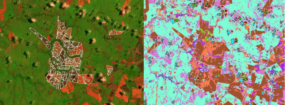
False color image scene (left) was captured from the Landsat 5 satellite in December 2009. An unsupervised classification technique was used to detect crop fields over the entire country of Uruguay. The image on the right is post-classification. Following classification, crop fields appear as shades of brown.
Guadalupe Tiscornia, a research scientist with INIA, says the collaboration between her institution, IRI and NASA has been extremely beneficial.
“It’s helping us to monitor field crops and pasture status and to make production forecasts,” she said.
The initial results of the Uruguay project have proved so promising that Ceccato and Ng are now implementing this research as part of a World Bank grant between IRI and Uruguay. Ng now works on the project full-time and Yang is expected to join the project again in January. Next spring, Ceccato plans to train staff in Uruguay’s Ministry of Agriculture to perform the crop analysis themselves, and the IRI team will work on using the analysis to develop new methodologies for crop model predictions.
Ceccato has been extremely pleased with the NASA DEVELOP internships.
“It’s a good opportunity for students to try new things and be creative using remote sensing for new applications. The internships are short and the work is very challenging,” he says. “For scientists, it’s a good opportunity to investigate new approaches and test new hypotheses that contribute to our ongoing research in remote sensing applications.”
The DEVELOP program at IRI will continue into spring 2014, with Kruczkiewicz and fellow intern Jerrod Lessel exploring the relationship between inundation and vector borne diseases using remote sensing.
Project summaries and videos from the last three terms are available at the links below.
Spring 2013
Sunny Ng, Improving Crop Yield Forecasting in Uruguay using Landsat Imagery
Caitlin Reid, Utilizing NASA EOS to Improve Early Warning and Mitigation of Malaria in Ethiopia
Summer 2013
Caitlin Reid and Alex Sweeney, Of Sandflies and Men: Environmental Factors Contributing to Kala Azar Outbreaks
Sunny Ng and Yifang Yang, Using NASA Earth Observations and a Temporal-Based Decision Model to Identify Crops
Elisabeth Gawthrop and Tammy Tran, Examining Meningococcal Meningitis and Climate in the Sahel
Fall 2013
Jerrod Lessel, Drought Drought Everywhere, And Not a Model to Use: Monitoring Drought in Uruguay
Andrew Kruczkiewicz and Alexandra Sweeney, Toward Early Warning and Early Action in Sudan: Public Health and the Environment
You must be logged in to post a comment.