IRI ENSO Forecast
IRI Technical ENSO Update and Model-Based Probabilistic ENSO Forecast
Published: March 20, 2014
Recent and Current Conditions
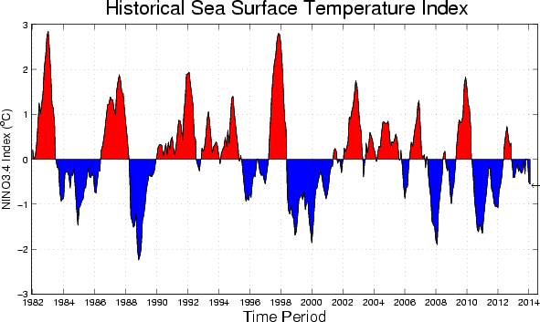
The SST anomaly in the Nino3.4 region in recent weeks has been near the borderline between neutral and weak Niña, through mid-March 2014. For February 2014 the Nino3.4 SST anomaly was -0.55 C, indicative of weak La Niña conditions, and for December-February it was -0.37 C. The IRI’s definition of El Niño, like NOAA/Climate Prediction Center’s, requires that the SST anomaly in the Nino3.4 region (5S-5N; 170W-120W) exceed 0.5 C. Similarly, for La Niña, the anomaly must be -0.5 C or less. The climatological probabilities for La Niña, neutral, and El Niño conditions vary seasonally, and are shown in a table at the bottom of this page for each 3-month season. The most recent weekly SST anomaly in the Nino3.4 region was -0.4 C, which is just slightly warmer than the -0.55 C observed in February. The recent borderline weak La Niña conditions are considered a short-lived fluctuation and cannot by themselves be considered a La Niña event.
Expected Conditions
What is the outlook for the ENSO status going forward? The most recent official diagnosis and outlook was issued earlier this month in the NOAA/Climate Prediction Center ENSO Diagnostic Discussion, produced jointly by CPC and IRI; it called for a high likelihood of neutral ENSO conditions enduring into spring 2014, with probabilities of El Niño or La Niña each 40% or less until May-Jul 2014 after which El Niño probabilities rise to 50% by Aug-Oct 2014, and slightly above 50% through autumn 2014. The latest set of model ENSO predictions, from mid-March, now available in the IRI/CPC ENSO prediction plume, is discussed below. Currently, Nino3.4 SST anomalies are in the cool-neutral range. Anomalies are above average in the western part of the basin and somewhat below average in the east-central part of the basin (including the Nino3.4 region). Subsurface temperature anomalies across the central and eastern equatorial Pacific had become below average during January, but during late January and the first half of February had reversed to being slightly above average and currently have increased to more strongly above average levels. A strong Kelvin wave, triggered by two westerly wind events in the western tropical Pacific, is currently traversing the basin and helping increase the subsurface temperature anomaly. In the atmosphere, the basin-wide sea level pressure pattern (e.g. the SOI), had been somewhat as would be found during a weak La Niña during January, but this pattern weakened during February and is now closer to average. The low-level zonal winds have been anomalously westerly in the western tropical Pacific and near average over much of the remainder of the basin. Slightly enhanced westerlies have been observed at upper levels of the atmosphere in a portion of the east-central tropical Pacific. Anomalous convection (as measured by OLR) has been negative in the central tropical Pacific, and positive in the western part of the basin. Together, these features reflect ENSO-neutral conditions. The current Kelvin wave moving toward the South American coast may serve to further increase the subsurface heat content and has the potential to raise the SST in the far eastern part of the basin. This, in turn, could induce anaomlous low level westerlies in the central and eastern part of the equatorial Pacific, which could lead to a coupling of ocean and atmosphere in such a way as to induce the onset of El Niño conditions.
As of mid-March, 4% of the dynamical or statistical models models predicts La Niña SST conditions for the Mar-May 2014 season, none predicts El Niño conditions, and 96% indicates neutral ENSO. At lead times of 3 or more months into the future, statistical and dynamical models that incorporate information about the ocean’s observed subsurface thermal structure generally exhibit higher predictive skill than those that do not. For the Jun-Aug 2014 season, among models that do use subsurface temperature information, 41% predicts ENSO-neutral SSTs, 59% predicts El Niño conditions and none predicts La Niña conditions. For all model types, the probability for neutral ENSO conditions is above 70% for Mar-May and Apr-Jun 2014, is 67% for May-Jul 2014, and is not far from 30% Jul-Sep through Nov-Jan 2014-15 at the end of the forecast period. Probabilities for El Niño are below 40% through May-Jul 2014, rise to 59% for Jun-Aug, and settle in the 64-73% range from Jul-Sep through Nov-Jan. No model predicts La Niña conditions for any of the 3-month periods between Apr-Jun and Nov-Jan.
Note – Only models that produce a new ENSO prediction every month are included in the above statement.
Caution is advised in interpreting the distribution of model predictions as the actual probabilities. At longer leads, the skill of the models degrades, and skill uncertainty must be convolved with the uncertainties from initial conditions and differing model physics, leading to more climatological probabilities in the long-lead ENSO Outlook than might be suggested by the suite of models. Furthermore, the expected skill of one model versus another has not been established using uniform validation procedures, which may cause a difference in the true probability distribution from that taken verbatim from the raw model predictions.
An alternative way to assess the probabilities of the three possible ENSO conditions is more quantitatively precise and less vulnerable to sampling errors than the categorical tallying method used above. This alternative method uses the mean of the predictions of all models on the plume, equally weighted, and constructs a standard error function centered on that mean. The standard error is Gaussian in shape, and has its width determined by an estimate of overall expected model skill for the season of the year and the lead time. Higher skill results in a relatively narrower error distribution, while low skill results in an error distribution with width approaching that of the historical observed distribution. This method shows probabilities for La Niña at 5% for Mar-May 2014, decreasing to 3-5% through the end of the forecast period in Nov-Jan 2014-15. Model probabilities for neutral ENSO conditions are above 75% for Mar-May and Apr-Jun 2014, 57% for May-Jul, 46% for Jun-Aug, and between 37% and 41% for Jul-Sep through Nov-Jan 2014-15 at the end of the forecast period. Probabilities for El Niño are below 20% through Apr-Jun 2014, rise to 50% for Jun-Aug, near 55% for Jul-Sep, and near 60% for Sep-Nov through Nov-Jan 2014-15. It is clear that the models collectively favor neutral ENSO conditions into northern spring 2014, until around Jun-Aug when El Niño probabilities become competitive with ENSO-neutral probabilities, followed by the remainder of 2014 when El Niño becomes somewhat more likely than neutral. A plot of the probabilities generated from this most recent IRI/CPC ENSO prediction plume using the multi-model mean and the Gaussian standard error method summarizes the model consensus out to about 10 months into the future. The same cautions mentioned above for the distributional count of model predictions apply to this Gaussian standard error method of inferring probabilities, due to differing model biases and skills. In particular, this approach considers only the mean of the predictions, and not the total range across the models, nor the ensemble range within individual models.
The probabilities derived from the models on the IRI/CPC plume describe, on average, maintenance of neutral ENSO conditions into northern spring 2014. A good possibility for El Niño development is seen starting in Jun-Aug 2014, as the objective model-based probabilities for El Niño begin exceeding those for neutral ENSO through Nov-Jan 2014-15 at the end of the forecast period. The uncertainty will diminish as we progress through the northern spring predictability barrier in the coming two to three months. A caution regarding this latest set of model-based ENSO plume predictions, is that factors such as known specific model biases and recent changes that the models may have missed will be taken into account in the next official outlook to be generated and issued in early October by CPC and IRI, which will include some human judgement in combination with the model guidance.
Climatological Probabilities
| Season |
La Niña |
Neutral |
El Niño |
| DJF |
37% |
28% |
35% |
| JFM |
34% |
37% |
29% |
| FMA |
30% |
48% |
22% |
| MAM |
26% |
54% |
20% |
| AMJ |
24% |
54% |
22% |
| MJJ |
25% |
51% |
24% |
| JJA |
25% |
50% |
25% |
| JAS |
27% |
46% |
27% |
| ASO |
29% |
40% |
31% |
| SON |
32% |
34% |
34% |
| OND |
34% |
31% |
35% |
| NDJ |
37% |
27% |
36% |
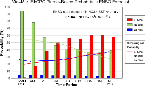
IRI/CPC Mid-Month Plume-Based ENSO Forecast Probabilities
| Season |
La Niña |
Neutral |
El Niño |
| MAM 2014 |
5% |
94% |
1% |
| AMJ 2014 |
5% |
78% |
17% |
| MJJ 2014 |
5% |
57% |
38% |
| JJA 2014 |
4% |
46% |
50% |
| JAS 2014 |
4% |
40% |
56% |
| ASO 2014 |
4% |
41% |
55% |
| SON 2014 |
3% |
37% |
60% |
| OND 2014 |
3% |
37% |
60% |
| NDJ 2014 |
3% |
39% |
58% |