May 2014 Climate Briefing: Weak El Niño Developing
From the May climate briefing, given by IRI’s Chief Forecaster Tony Barnston:
Tony Barnston provides an overview of the briefing
Changes from last month’s briefing
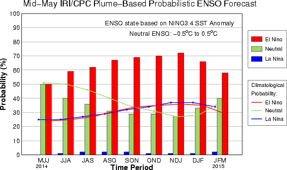
The IRI/CPC probabilistic ENSO forecast issued mid-May 2014. Note that bars indicate likelihood of El Niño occurring, not its potential strength. Unlike the official ENSO forecast issued at the beginning of each month, IRI and CPC issue this updated forecast based solely on model outputs. The official forecast, available at http://1.usa.gov/1j9gA8b, incorporates human judgement.
El Niño Southern Oscillation (ENSO) conditions are borderline neutral/El Niño. The Nino3.4 sea surface temperature anomaly was +0.5° C last week, which is the threshold for El Niño. Forecaster Tony Barnston expects a weak El Niño to continue to develop in the next few weeks. The IRI’s May ENSO forecast puts the chances of El Niño conditions at just under 70% for early next fall (see image at right), a slight decrease from IRI’s April forecast and from NOAA/IRI’s official prediction issued on May 8. A possible reason for the slightly lower probability is some weakness in the positive feedback loop typically seen in El Niño events between the atmosphere and warm ocean temperatures in the equatorial Pacific.
Models are currently predicting El Niño of moderate strength, though a strong or weak El Niño is also still possible. Certainty in the strength has increased somewhat, though we are still within the time of the “spring predictability barrier.” During April, May, and June, the state of the central Pacific is dynamic and can change quickly, making it hard to predict how it will behave in the coming months. In June, indications of potential strength should become more clear.
Effects of El Niño on global seasonal climate forecasts
Each month, IRI issues seasonal climate forecasts for the entire globe. These forecasts, which take into account the latest ENSO projections, indicate which areas are more likely to see above or below normal temperatures and rainfall. The latest forecasts are showing moderate impact to climate in areas typically influenced by El Niño (view the seasonal forecasts here). The area with the strongest chance for below-average rainfall is Indonesia. Areas of Central America also have a higher probability of below-average precipitation during late Northern Hemisphere summer.
Scientists should know more each month about the chances for El Niño, its potential strength, and the climate impacts. Sign up here to get notified when the next forecast is issued, and in the meantime, check out #IRIforecast or use #ENSOQandA on Twitter to ask your El Niño questions.
You must be logged in to post a comment.