March Climate Briefing: El Niño’s Beginning..or End?
From the March climate briefing, given by IRI’s Chief Forecaster Tony Barnston:
Tony Barnston provides an overview of the briefing
Changes from last month’s briefing
Earlier this month, the National Oceanic and Atmospheric Administration’s Climate Prediction Center and IRI issued an El Niño advisory, which indicates that El Niño conditions are present and expected to persist for the next several months. This forecast update supports that expectation, with a 59% chance of El Niño conditions in the current March-May season, and rising for the following few months to around 70%.
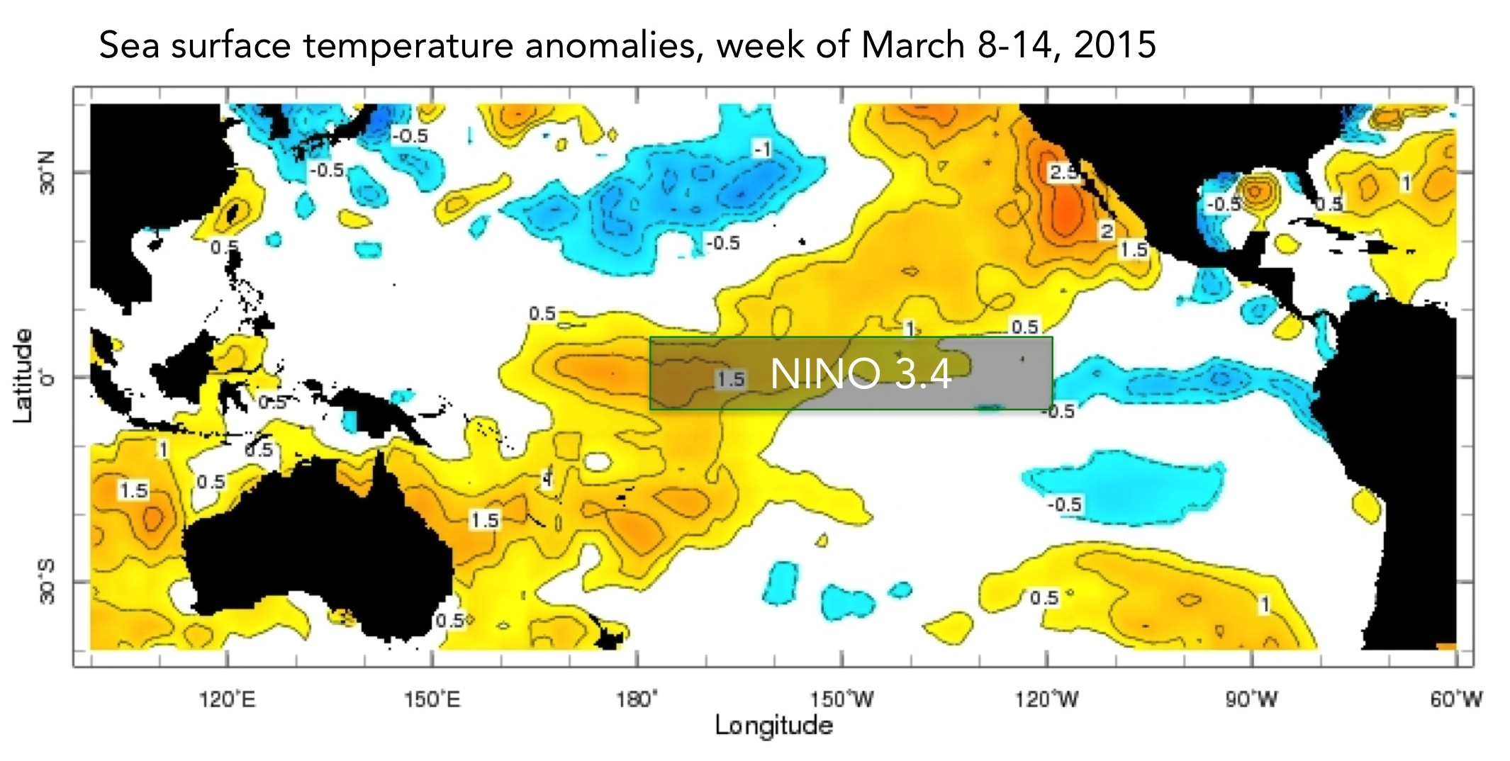
Sea-surface temperature anomalies in the Nino3.4 region (see first image) continue to hover around 0.5ºC, as they have since October. Barnston said the reason for the recent official El Niño designation is that trade winds in the tropical Pacific became anomalous and there is increased convection near the intersection of the equator and the international dateline. Both of these are indicative of atmospheric conditions consistent with El Niño.
Eastern Pacific typhoons
The recent typhoon activity in the western Pacific may also exert some influence on the El Niño, and it’s likely the current anomalous trade winds and increased sea-surface temperatures in the area contributed to the storms’ development.
“Although the storms can encourage the westerly wind anomalies to persist, they are a fairly small factor in maintaining or growing the El Niño compared with other factors present before the storms,” said Barnston. “These include the MJO in phase 7 or 8–which is just right to promote El Niño–and the anomalous winds. It is doubtful they will be the deciding factor for whether or not we get a moderate (or greater) El Niño by mid-summer. We are still up against the spring barrier, a time of great uncertainty when other small factors can come along and make a difference, either favoring or opposing El Niño.”
Forecasting through ENSO’s foggy spring predictability
In somewhat of a parallel to last year at this time, a Kelvin wave is making its way across the equatorial Pacific, bringing more subsurface heat to the central and eastern Pacific Ocean. Compared to last year, however, this wave is slightly less strong but coming a little later in the season. The later timing may mean it’s more likely to influence the ENSO cycle past the spring predictability barrier over the next couple of months.
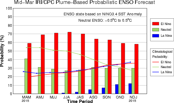
The IRI/CPC probabilistic ENSO forecast issued mid-February 2015. Note that bars indicate likelihood of El Niño occurring, not its potential strength. Unlike the official ENSO forecast issued at the beginning of each month, IRI and CPC issue this updated forecast based solely on model outputs. The official forecast, available at http://1.usa.gov/1j9gA8b, incorporates human judgement.
Barnston said it is unclear whether the anomalous tradewinds, dateline convection and Kelvin wave propagation are a last-minute push from the end of the current ENSO year (if considering an ENSO year to be May-May), or a sign of a new, blossoming El Niño event, or perhaps both.
However one characterizes the timing of these latest ENSO developments, the dynamical models are anticipating a moderately strong event to develop in the Northern Hemisphere’s late spring and summer. They are notoriously bad for seeing through the spring predictability barrier, though, so it should be noted that the statistical models are more conservative, predicting a neutral-to-weak El Niño event.
Effects of El Niño on global seasonal forecasts
 Each month, IRI issues seasonal climate forecasts for the entire globe. These forecasts take into account the latest ENSO SST projections and indicate which areas are more likely to see above or below normal temperatures and rainfall. For the April-June period, the forecast continues to show a strong likelihood of drier-than-normal conditions over Indonesia and northeastern South America (image right). Wetter-than-average conditions continue to be somewhat more likely in the southeastern United States.
Learn more about El Niño on our ENSO resources page, and sign up here to get notified when the next forecast is issued. In the meantime, check out #IRIforecast or use #ENSOQandA on Twitter to ask your El Niño questions.
You must be logged in to post a comment.