December Climate Briefing: El Limbo Continues
From the December climate briefing, given by IRI’s Chief Forecaster Tony Barnston:
Tony Barnston provides an overview of the briefing
Changes from last month’s briefing
Based on the latest models, the chance of an El Niño developing during the current (December-February) season is over 80%, up slightly from last month. These odds for the current season are also higher than those issued by the NOAA Climate Prediction Center/IRI forecast on December 4.
Although the odds of El Niño conditions for the next few months are up slightly from last month, the present ocean and atmosphere conditions are similar to this time last month. Sea-surface temperatures in the Nino3.4 region (see image) were 0.9ºC above average over the last week and 0.85ºC above average over the last month, which is unequivocally above the +0.5ºC threshold considered to indicate El Niño conditions. These temperature averages, however, are a relatively “instantaneous” measurement, and an El Niño event will only happen if these conditions are sustained for the next several months. Upper level winds as well as the Southern Oscillation Index, an indicator of atmospheric pressure patterns, are showing atmospheric conditions consistent with El Niño development, although on the weak side. Despite these favorable atmospheric indicators, the lack of convection (i.e. cloudiness and rainstorms) in the equatorial Pacific is still the major component of El Niño missing. Convection in this area is what experts think produces the teleconnections leading to a cascade of atmospheric pattern shifts that cause the global impacts of El Niño.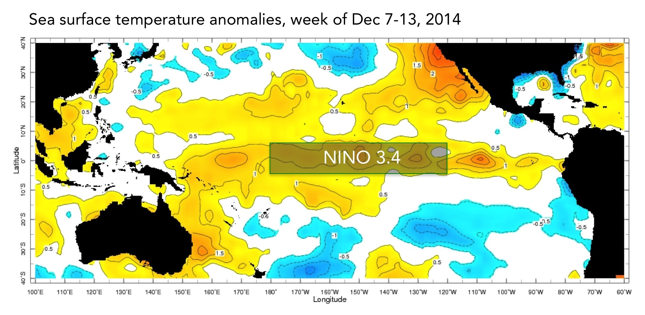
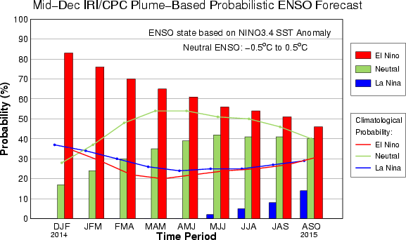
The IRI/CPC probabilistic ENSO forecast issued mid-December 2014. Note that bars indicate likelihood of El Niño occurring, not its potential strength. Unlike the official ENSO forecast issued at the beginning of each month, IRI and CPC issue this updated forecast based solely on model outputs. The official forecast, available at http://1.usa.gov/1j9gA8b, incorporates human judgement.
Effects of El Niño on global seasonal forecasts
 Each month, IRI issues seasonal climate forecasts for the entire globe. These forecasts take into account the latest ENSO SST projections and indicate which areas are more likely to see above or below normal temperatures and rainfall. Climate impacts are expected to resemble those of a weak El Niño, with the strongest impacts being felt in areas closest to the tropics. For the February-April period, the forecast continues to show a strong likelihood of drier-than-normal conditions over Indonesia, and some enhanced likelihood of dry weather in northern South America and parts of southern Africa (image right). Wetter-than-average conditions are somewhat more likely in the southwestern United States and Florida.
Scientists should know more each month about the chances for El Niño, its potential strength, and the climate impacts. Sign up here to get notified when the next forecast is issued, and in the meantime, check out #IRIforecast or use #ENSOQandA on Twitter to ask your El Niño questions.
You must be logged in to post a comment.