April Climate Briefing: Models Bullish on El Niño Odds
Read our ENSO Essentials & Impacts pages for more about El Niño.
Tony Barnston provides an overview of the briefing
Since last month’s briefing, weekly sea-surface temperature anomalies have held steady at +0.2ºC to +0.3ºC in the area of the central equatorial Pacific Ocean that define El Niño and La Niña events, called the Nino3.4 region. While these sea-surface temperatures (SSTs) point to a neutral ENSO state, convection (i.e. clouds and thunderstorms) over Indonesia continues to linger in a La Niña-like pattern (see second image). At the other end of the Pacific, sea surface temperatures in the eastern part of the basin were well-above normal for January, February, March and part of April, directly contributing to the extreme rainfall and flooding seen in northwestern South America over the past month. In a recent blog post for NOAA’s Climate.gov, Barnston provides more details about the conflicting ENSO signals from the Pacific Ocean.
The National Oceanic and Atmospheric Administration’s Climate Prediction Center’s ENSO alert system status is currently listed as Not Active.


ENSO Forecasts
To predict ENSO conditions, computers model the SSTs in the Nino3.4 region over the next several months. The graph in the first image of the gallery below shows the outputs of these models, some of which use equations based on our physical understanding of the system (called dynamical models), and some of which use statistics, based on the long record of historical observations.
The means of both the dynamical and statistical models are similar to those of last month, with both calling for SSTs at or above the El Niño threshold of +0.5ºC later in the year. The statistical model mean only just reaches the threshold, staying in the range of a weak El Niño event. The dynamical model mean reaches +1.0ºC, which translates to a moderate El Niño event.
Just as last month, these forecasts extend past what’s known as the spring predictability barrier — a function of ocean dynamics that makes it hard to predict ENSO past June of each year. Uncertainty is therefore high, as indicated by the nearly 2.5ºC spread of model predictions.


Based on these model outputs, odds for La Niña are close to zero for the next several seasons, with neutral conditions most likely during the current April-June season (see second graph in gallery above). El Niño then takes over as the most likely ENSO state for the rest of the year, topping out at nearly 70% for the August-October season.
ENSO in context: Resource page on climate variability
The official probabilistic forecast issued by CPC and IRI in early April shows a similar overall pattern, but with the highest odds for El Niño conditions only reaching about 50%. This early-April forecast uses human judgement in addition to model output, while the mid-April forecast relies solely on model output. More on the difference between these forecasts in this recent IRI Medium post.
Effects of La Niña on global seasonal forecasts
Each month, IRI issues seasonal climate forecasts for the entire globe. These forecasts take into account the latest model outputs and indicate which areas are more likely to see above- or below-normal temperatures and rainfall.
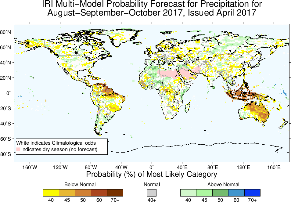
For the upcoming seasons, the forecasts show some signal from ENSO, such as increased chances for drier-than-normal conditions in northeastern South America. The season with the strongest ENSO signal forecasted is August-October (image above). Here, we see especially strong dry signals in Indonesia, Australia and again northeastern South America. All forecast maps are available on our seasonal forecast page.
Learn more about El Niño and La Niña on our ENSO resources page, and sign up here to get notified when the next forecast is issued. In the meantime, check out #IRIforecast.
You must be logged in to post a comment.