IRI ENSO Forecast
IRI Technical ENSO Update
Published: September 15, 2016
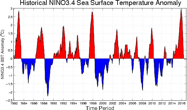
Note: The SST anomalies cited below refer to the OISSTv2 SST data set, and not ERSSTv4. OISSTv2 is often used for real-time analysis and model initialization, while ERSSTv4 is used for retrospective official ENSO diagnosis because it is more homogeneous over time, allowing for more accurate comparisons among ENSO events that are years apart. During ENSO events, OISSTv2 usually shows stronger anomalies than ERSSTv4, and during very strong events the two datasets may differ by as much as 0.5 C.
Recent and Current Conditions
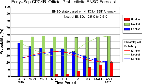
ENSO-neutral conditions were observed in most ENSO-related variables from May through July 2016. For August 2016 the average NINO3.4 SST anomaly was -0.54 C, indicative of weak La Niña SST conditions. For Jun-Aug it was -0.38 C, in the ENSO-neutral category. The IRI’s definition of El Niño, like NOAA/Climate Prediction Center’s, requires that the SST anomaly in the Nino3.4 region (5S-5N; 170W-120W) exceed 0.5 C. Similarly, for La Niña, the anomaly must be -0.5 C or less. The climatological probabilities for La Niña, neutral, and El Niño conditions vary seasonally, and are shown in a table at the bottom of this page for each 3-month season. The most recent weekly anomaly in the Nino3.4 region was -0.6, at a weak La Niña level. However, accompanying this ocean condition, is a mixture of some indications of La Niña and some of ENSO-neutral. Lower-level zonal wind anomalies have been near-zero. Convection anomalies across the equatorial Pacific are somewhat suggestive of La Niña, as is the Southern Oscillation Index (SOI). Overall, despite the SST, the case for weak La Niña is not beyond reason, but also not very compelling so far.
Expected Conditions
What is the outlook for the ENSO status going forward? The most recent official diagnosis and outlook was issued one week ago in the NOAA/Climate Prediction Center ENSO Diagnostic Discussion, produced jointly by CPC and IRI; it called for a roughly 55-60% likelihood of continued neutral ENSO conditions during fall and winter 2016-17, and a La Niña watch that had been posted in August was discontinued. The latest set of model ENSO predictions, from mid-September, now available in the IRI/CPC ENSO prediction plume, is discussed below. Currently, the Nino3.4 SST anomalies are at the level of minimal La Niña. Subsurface temperature anomalies across the eastern equatorial Pacific continue to be somewhat below average, and have slightly decreased in recent weeks. Although enhanced easterly trade winds have not yet been observed, the slightly below-average SSTs and the negative subsurface heat content anomaly may support the onset of such enhanced trades in the eastern tropical Pacific. When and if these develop, the SST could fall remain in the weak La Niña category during late September and October, and if this happens the La Niña condition might last, even if only weak, through the fall. However, the collection of the latest model predictions suggest that this scenario is about as likely to happen as not to happen, with probabilities just over 50%.
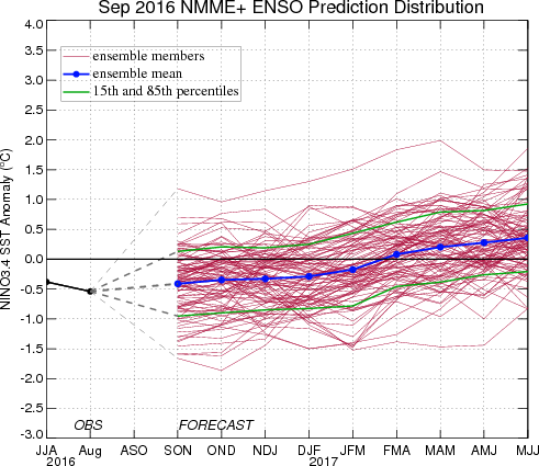
As of mid-September, 62% of the dynamical or statistical models predicts La Niña conditions for the initial Sep-Nov 2016 season, while 38% predict neutral ENSO. At lead times of 3 or more months into the future, statistical and dynamical models that incorporate information about the ocean’s observed subsurface thermal structure generally exhibit higher predictive skill than those that do not. For the Dec-Feb 2016-17 season, among models that do use subsurface temperature information, 47% predicts ENSO-neutral conditions and 53% predicts La Niña conditions. For all model types, the probabilities for La Niña are between 50% and 70% from Sep-Nov 2016 through Dec-Feb 2016-17, then drop into the 40s during later winter 2016-17 and below 25% from Mar-May 2017 onward. The probability for neutral conditions rises to 50% for Nov-Jan and Dec-Feb, and still higher thereafter. No model predicts El Niño until Apr-Jun, when 6% (one model) does.
Note – Only models that produce a new ENSO prediction every month are included in the above statement.
Caution is advised in interpreting the distribution of model predictions as the actual probabilities. At longer leads, the skill of the models degrades, and skill uncertainty must be convolved with the uncertainties from initial conditions and differing model physics, leading to more climatological probabilities in the long-lead ENSO Outlook than might be suggested by the suite of models. Furthermore, the expected skill of one model versus another has not been established using uniform validation procedures, which may cause a difference in the true probability distribution from that taken verbatim from the raw model predictions.
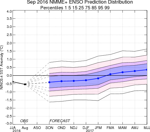
An alternative way to assess the probabilities of the three possible ENSO conditions is more quantitatively precise and less vulnerable to sampling errors than the categorical tallying method used above. This alternative method uses the mean of the predictions of all models on the plume, equally weighted, and constructs a standard error function centered on that mean. The standard error is Gaussian in shape, and has its width determined by an estimate of overall expected model skill for the season of the year and the lead time. Higher skill results in a relatively narrower error distribution, while low skill results in an error distribution with width approaching that of the historical observed distribution. This method shows probabilities for La Niña at 55% for Sep-Nov 2016, decreasing slowly to 52% by Dec-Feb 2016-17, then droping to 46% for Jan-Mar 2017 and much lower thereafter. Probabilities for El Niño are below 5% through Mar-May 2017, and rise to 12% by the final forecast period of May-Jul 2017. Probabilities for ENSO-neutral are below 50% through Dec-Feb 2016-17, 50% for Jan-Mar 2017, and rise thereafter. A plot of the probabilities generated from this most recent IRI/CPC ENSO prediction plume using the multi-model mean and the Gaussian standard error method summarizes the model consensus out to about 10 months into the future. The same cautions mentioned above for the distributional count of model predictions apply to this Gaussian standard error method of inferring probabilities, due to differing model biases and skills. In particular, this approach considers only the mean of the predictions, and not the total range across the models, nor the ensemble range within individual models.
In summary, the probabilities derived from the models on the IRI/CPC plume describe, on average, a likelihood for La Niña conditions 50-55% for Sep-Nov 20167 through Dec-Feb 2016-17, and drop below 50% by early 2017 and beyond. A caution regarding this latest set of model-based ENSO plume predictions, is that factors such as known specific model biases and recent changes that the models may have missed will be taken into account in the next official outlook to be generated and issued in early October by CPC and IRI, which will include some human judgement in combination with the model guidance.
Climatological Probabilities
| Season |
La Niña |
Neutral |
El Niño |
| DJF |
36% |
30% |
34% |
| JFM |
34% |
38% |
28% |
| FMA |
28% |
49% |
23% |
| MAM |
23% |
56% |
21% |
| AMJ |
21% |
58% |
21% |
| MJJ |
21% |
56% |
23% |
| JJA |
23% |
54% |
23% |
| JAS |
25% |
51% |
24% |
| ASO |
26% |
47% |
27% |
| SON |
29% |
39% |
32% |
| OND |
32% |
33% |
35% |
| NDJ |
35% |
29% |
36% |
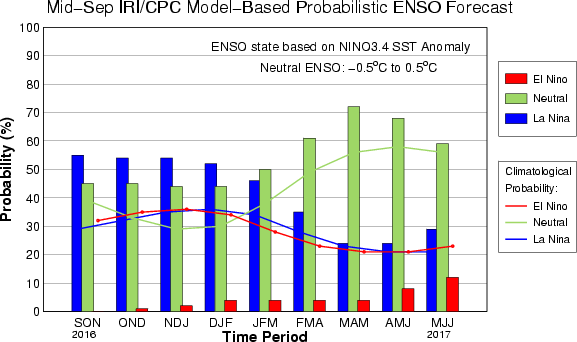
IRI/CPC Mid-Month Model-Based ENSO Forecast Probabilities
| Season |
La Niña |
Neutral |
El Niño |
| SON 2016 |
55% |
45% |
0% |
| OND 2016 |
54% |
45% |
1% |
| NDJ 2016 |
54% |
44% |
2% |
| DJF 2017 |
52% |
44% |
4% |
| JFM 2017 |
46% |
50% |
4% |
| FMA 2017 |
35% |
61% |
4% |
| MAM 2017 |
24% |
72% |
4% |
| AMJ 2017 |
24% |
68% |
8% |
| MJJ 2017 |
29% |
59% |
12% |