November Climate Briefing: El Limbo
From the November climate briefing, given by IRI’s Chief Forecaster Tony Barnston:
Tony Barnston provides an overview of the briefing
Changes from last month’s briefing
Based on the latest models, the chance of an El Niño developing during the current (November-January) season is about 75%, up slightly from last month. These odds for the November-January season are also higher than those issued by the NOAA Climate Prediction Center/IRI forecast on November 6.
Last week’s sea surface temperatures in the Nino3.4 region (see image) were 0.8ºC above average, which is unequivocally over the +0.5ºC threshold considered to indicate El Niño conditions. These weekly temperature averages, however, are a relatively “instantaneous” measurement, and an El Niño event will only happen if these conditions are sustained for the next several months. Upper level winds as well as the Southern Oscillation Index, an indicator of atmospheric pressure patterns, are showing atmospheric conditions consistent with El Niño development. Despite these favorable atmospheric indicators, the lack of convection (i.e. cloudiness and rainstorms) in the equatorial Pacific is a major component of El Niño that is still missing. The convection in this area is what’s thought to produce the teleconnections leading to a cascade of atmospheric pattern shifts that cause the global impacts of El Niño.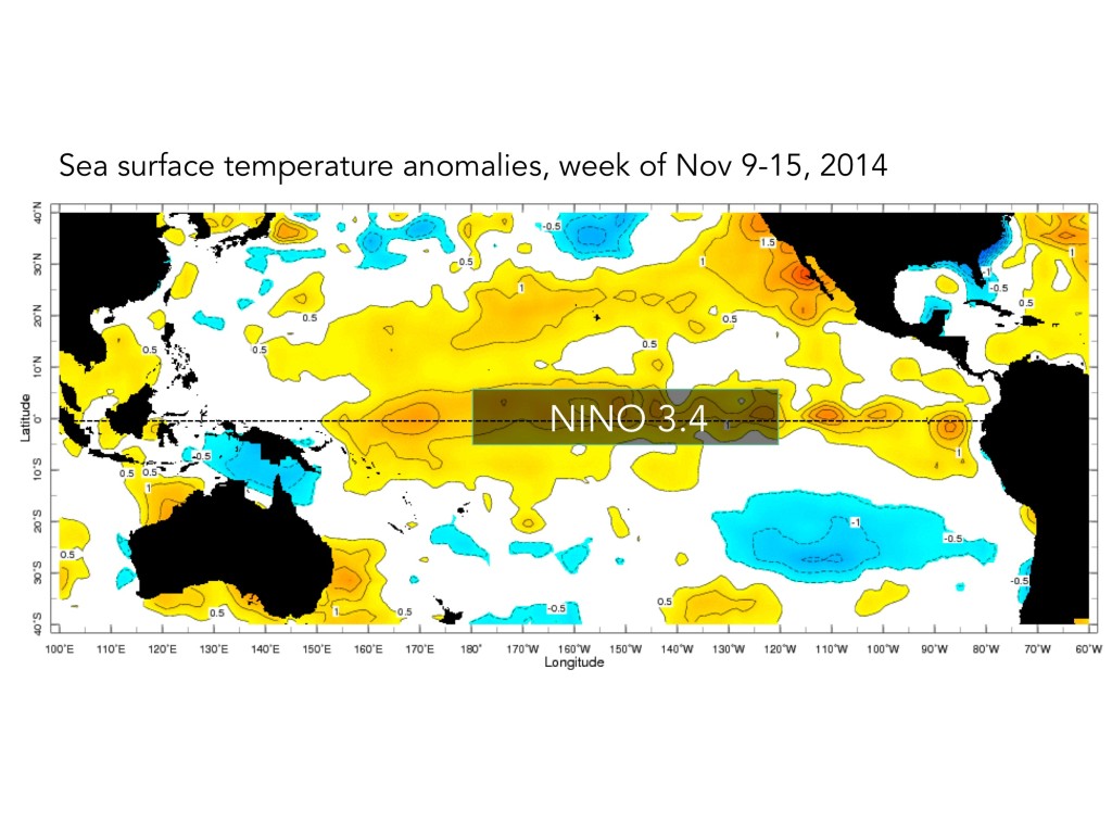
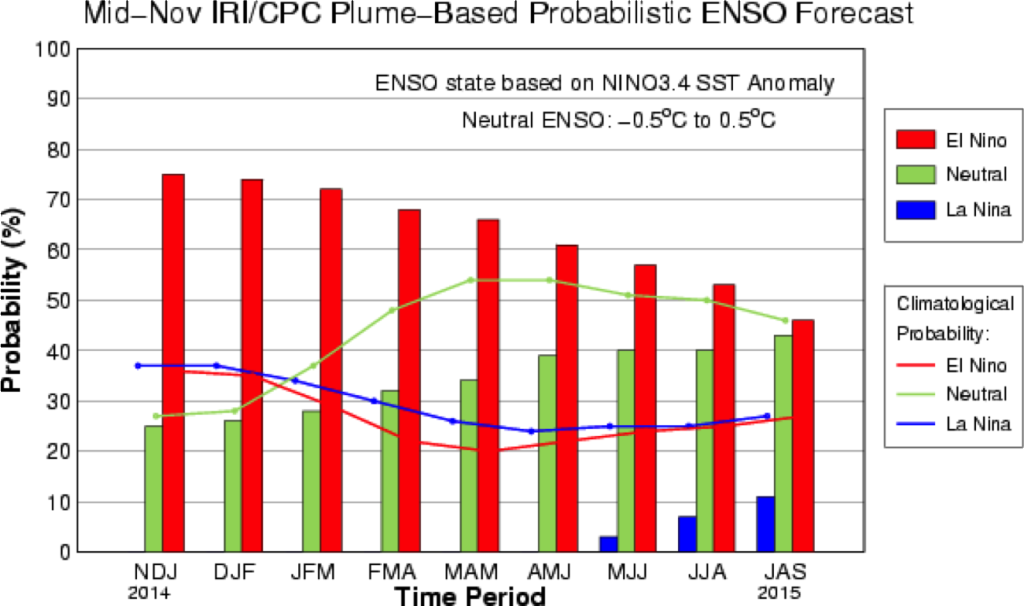
The IRI/CPC probabilistic ENSO forecast issued mid-November 2014. Note that bars indicate likelihood of El Niño occurring, not its potential strength. Unlike the official ENSO forecast issued at the beginning of each month, IRI and CPC issue this updated forecast based solely on model outputs. The official forecast, available at http://1.usa.gov/1j9gA8b, incorporates human judgement.
Still up in the air
It would be very unusual for an El Niño event to begin this late in the season, though dynamically it is still possible, and indeed it’s predicted by most models. If we do have sustained conditions consistent with a weak El Niño, “it’s possible that we may only have them for a few months, which isn’t long enough for NOAA to include it on the official list of El Niño events,” said Barnston.
For the National Oceanograhic and Atmospheric Association (NOAA) to enter an El Niño in the historical record, it has to run for five consecutive 3-month periods. Barnston said there is also a possibility that it will pass their definition, and if it does, there’s an outside chance we will have a second year of El Niño because of its late start — it may not have a chance to run its course before the next cycle starts.
Effects of El Niño on global seasonal forecasts
 Each month, IRI issues seasonal climate forecasts for the entire globe. These forecasts take into account the latest ENSO projections and indicate which areas are more likely to see above or below normal temperatures and rainfall. Although an El Niño has yet to develop, climate impacts are still expected to resemble those of a weak El Niño. For the January-March period, the forecast continues to show a likelihood of drier than normal conditions over Indonesia and northern South America (image right). Wetter-than-average conditions are expected in the southern United States.
Scientists should know more each month about the chances for El Niño, its potential strength, and the climate impacts. Sign up here to get notified when the next forecast is issued, and in the meantime, check out #IRIforecast or use #ENSOQandA on Twitter to ask your El Niño questions.
You must be logged in to post a comment.