Digital innovation harnesses power of real-time weather data
Written by Amanda Grossi and Francesco Fiondella
This story is adapted from one originally published by Accelerating Impacts of CGIAR Climate Research for Africa (AICCRA).
A new data-management and visualization tool developed at IRI is helping national meteorological services and regional climate centers across Africa harness real-time weather data for decision-making in agriculture.
National meteorological services play a central role in their country’s efforts to anticipate and manage climate-related risks, and to develop effective policies for resilience and adaptation.
The real-time monitoring of floods, droughts and other climate hazards—as well the various climate and weather forecasts the national meteorological services provide—help agencies make critical decisions about agriculture, public health, energy, transportation, and other fundamental components of society.
However, these operations require vast amounts of reliable and timely climate and weather data. This is something that, historically, many African countries have lacked.
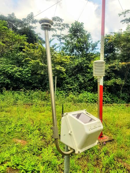
Recent initiatives backed by the UN Development Program, the World Bank and other international partners have worked to increase the availability and quality of climate data on the continent, particularly by investing in networks of automated weather stations (AWS). These stations demand far less human involvement than traditional ones, which require staff visits to collect data–multiple times a day in some cases. Automated stations can take measurements every fifteen minutes and automatically transmit the data to a meteorological office. They can also be set up in places where continuous weather data has been more difficult to collect, such as in remote rural communities.
This higher-resolution data creates more robust historical climate datasets that ultimately lead to improved climate predictions and forecasts for a country.
When it comes to responding to—and mitigating—climate emergencies, having these real-time data networks can make all the difference.
A new data challenge
The rapid expansion of automated weather-monitoring networks is addressing critical data gaps across Africa. But they’ve also created a new problem, one caused by a lack of coordination among the various initiatives, programs, and donors who have funded the building of these networks.
The result is that a given country may have many types of automated networks, each built by a different company, and each requiring different parts and processes to maintain and repair.
Also, these companies don’t format and store their AWS data in the same way–some use proprietary formats. So while automated stations do provide national meteorological services with a lot of critical weather data (good), the different AWS networks can’t ‘talk’ to each other (not good). If a national meteorological service cannot efficiently combine, synchronize, and analyze its datasets, then a significant amount of data will be left out of decision making.
Scaling a transformative solution
Scientists at Columbia University’s International Research Institute for Climate and Society (IRI) saw this challenge and the frustration it was causing among its many national met service partners. In response, they developed the Automatic Weather Station Data Tool (ADT). And thanks to support from the Accelerating Impact of CGIAR Climate Research for Africa (AICCRA) and Adapting Agriculture to Climate Today, for Tomorrow (ACToday) projects to hold technical trainings and workshops, use of the new tool has increased significantly among African national meteorological services.
ADT is a free web-based application with an easy-to-use graphic interface that enables users from national meteorological services to access, process, perform quality control, and visualize data from different automated networks in one place. It also enables real-time monitoring of stations to see which ones are working and which ones are offline to more easily understand where the data is coming from and address any interruptions in transmission sooner. ADT emerged from the broader climate services delivered under the Enhancing National Climate Services (ENACTS) initiative, which recognized that the availability of high-quality climate data does not automatically translate to ease of access or effective use.
In less than a year, IRI has trained dozens of staff from the national meteorological services in Ethiopia, Ghana, Kenya, Senegal, and Zambia to use ADT to help synchronize their data streams. Mali’s meteorological service is hoping to receive similar trainings in the near future.
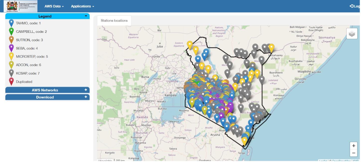
In Kenya, where the national meteorological department has faced considerable challenges trying to manage seven different automatic weather station networks, the tool has greatly simplified the analysis and viewing of weather data.
“The data visualization capabilities of ADT will go a long way in supporting our mandate of providing quality and timely climate information to the users. Its ability to aggregate different data types is a game changer,” said Onesmus Ruirie, Principal Meteorologist at the Kenya Meteorological Department.
“The data visualization capabilities of ADT will go a long way in supporting our mandate of providing quality and timely climate information to the users. Its ability to aggregate different data types is a game changer.”
Onesmus Ruirie, Kenya Meteorological Department.
The functionality to aggregate data at hourly, daily, 10-daily, and monthly intervals has many meteorological staff excited, especially when complemented by the ability to display and download maps, graphs, and tables of this data for reports or advisories for decision makers.
IRI is a key partner in the AICCRA project, whose theory of change states that if national meteorological agencies can efficiently aggregate, analyze, and visualize climate data using state-of-the-art practices and tools, then relevant national institutions and stakeholders can better monitor, prepare and respond to climate-driven disasters in more timely and effective fashion. These same stakeholders can also inform long-term national strategies for adapting to climate change with more robust evidence.
Regional climate centers such as East Africa’s IGAD Climate Prediction and Applications Centre (ICPAC) have also recognized the role ADT can play in helping the met services develop improved climate services. ICPAC is enthusiastic about raising awareness about the tool and building capacity for its use in the region. In addition to Ethiopia and Kenya, IGAD member states include Djibouti, Somalia, South Sudan, Sudan, and Uganda.
“[ADT’s] capability to process data from automatic weather stations, its visualization functionalities, and its provision of a unified database for the different networks makes it a powerful tool for managing data for East Africa,” said Herbert Misiani, a data management expert at ICPAC.
ICPAC, another important AICCRA partner, has also helped the project scale other critical and in-demand IRI innovations in climate services to support the agricultural sector.
You must be logged in to post a comment.