Local beats global when it comes to national climate services in Rwanda
By Dannie Dinh, James Hansen, Floribert Vuguziga, Madeleine Thomson, Yohana Tekeste, and Aisha Owusu
This post originally appeared on the web site of the CGIAR Research Program on Climate, Agriculture and Food Security.
Climate data gaps are an obstacle to providing useful services for smallholder farmers
Climate information—and its use for farming decision making, index-based agricultural insurance, government agricultural planning and food security management—can benefit smallholder farmers. But these interventions depend on high-quality, long-term climate records, and are difficult to implement at scale in part because of inadequate observation networks and major gaps in historical records across much of sub-Saharan Africa.
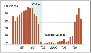
In addition to the data challenges that many developing countries face, Rwanda is faced with a near complete loss of data during a devastating period in its history. In the decade following the 1994 Rwanda Genocide, the number of operating weather stations dropped from more than 100 to less than 10, and did not begin to recover until 2010.
Meteo-Rwanda is using the ENACTS approach to overcome the challenges
The Enhancing National Climate Services (ENACTS) approach, developed by the International Research Institute for Climate and Society, focuses on enabling countries to produce reliable quality climate information suitable for national and local decision making. Through the ENACTS initiative, Rwanda’s National Meteorological Agency (Meteo-Rwanda) quality controlled its observational data, and merged their observations with global climate proxy satellite and reanalysis data using years with large amounts of data to calibrate global proxies for years where data are sparse.

This chart shows the number of operational weather stations in Rwanda
The result is a 30+ year historical database of rainfall and temperature (minimum and maximum) at a 4-5 km spatial resolution, with no gaps in space or time, readily accessible through the web-based “Maprooms” that are built using the IRI’s Data Library software and hosted on the Meteo-Rwanda website. The current climate Maprooms include historical climate analysis, climate monitoring, climate prediction, and information about climate and health. The Maprooms are being expanded to include additional information tailored to the needs of Rwanda’s agriculture sector, including downscaled seasonal and climate forecasts.
African national meteorological services can provide higher-quality climate information than global information providers
Previous research has shown that the quality of a merged satellite-station climate data set is largely a function of the amount of quality-controlled ground observations that go into the data. National meteorological services in Africa typically own more than an order of magnitude more data than they make publically available, and can therefore produce higher quality data sets than any global information provider.
Results from a recent science and training workshop, funded by the Strengthening Climate Information Partnerships – East Africa (SCIPEA) project and held at the IRI, provide further evidence of the added value of using national data sets to provide national climate services. Floribert Vuguziga, from Meteo-Rwanda, joined meteorologists from Ethiopia, Uganda and the IGAD Climate Prediction & Applications Centre (ICPAC) to explore predictability of the seasonal climate in Eastern Africa.
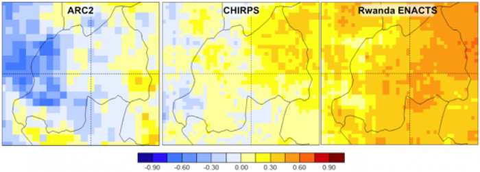
During the analyses, Vuguziga noticed that the same seasonal forecast model showed very different prediction skill (or accuracy relative to the information available without the forecasts) when it was developed and tested with different rainfall data sets. When global satellite-based rainfall datasets that incorporate limited local observations (ARC2 and CHIRPS) were used to train and test the prediction system, the seasonal forecasts appeared to have little skill. When offered less reliable seasonal forecast products with little prediction skill, a user might wonder whether it is worth using them at all. Using Meteo-Rwanda’s ENACTS data has allowed the forecast system to make better use of the potential predictability in the climate system, resulting in a higher level of skill that could potentially provide useful information to local decision makers.

Skill of seasonal rainfall forecasts for September-December 2016, made in August 2016 based on a global climate model (CFS v.2), as produced by two global data sets (CHIRPS and ARC2) and by a national data set (ENACTS). Higher correlation (red and orange) indicates more skillful forecasts.
Despite the significant loss of data in Rwanda’s meteorological observations record, the work of Meteo-Rwanda, using the ENACTS approach, is filling the gap and forming a foundation for climate services. “We have always wanted to reach people; that is our mission. Now users can self-serve through the Maprooms on Meteo-Rwanda’s website,” says Vuguziga. “Before ENACTS we thought our data gap would mean we could not provide a quality climate service. Now all that has changed.”
Close collaboration among partners, projects and donors is enabling significant advances in the quality and utility of climate information available to farmers and other local decision makers in East Africa. The aforementioned science and training workshop is part of the ongoing work in Rwanda and East Africa jointly sponsored by the U.K. Department for International Development (DfID) funded Weather and Climate Information Services (WISER) projects (ENACTS and SCIPEA) and the U.S. Agency for International Development (USAID) funded Rwanda Climate Services for Agriculture initiative. Implemented by the CGIAR Research Program on Climate Change, Agriculture and Food Security (CCAFS) and its partners through CCAFS’s Climate Services for Africa project, the Rwanda Climate Services for Agriculture initiative seeks to develop sustained capacity to provide climate services and support their use for agricultural planning and food security management.

You must be logged in to post a comment.