Behind the Expected Quiet 2015 Hurricane Season
By Chia-Ying Lee, IRI Postdoctoral Research Scientist
This post originally appeared in the Earth Institute’s State of the Planet Blog.
It does not feel like summer in New York City as I write, but today (a cool, rainy June 1) is the official start day for the Atlantic hurricane season, which will last until November 30. What makes these dates special? Nothing, really.
Tropical cyclones (the generic scientific name; if they occur in the Atlantic and Eastern Pacific, we call them hurricanes) form as they wish when the environment permits. The precise start date is artificial, except to remind us that it is time to revisit our hurricane preparation. And in fact, the first Atlantic tropical storm, Ana, already formed several weeks ago, on May 8. But historically, 97 percent of storms form within the six months of the canonical season.
One of the most popular hurricane questions the public asks is, “How many hurricanes are going to hit my home (or my city, or the entire U.S. if one is less self-focused) this year?” We can’t answer this, because skillful predictions of the number of land-falling storms in a given year are currently not feasible. However, the National Oceanic and Atmospheric Administration does issue predictions of the total number of storms within the Atlantic basin, without specifying where they will occur. A number of other groups worldwide, government, private and academic, issue similar forecasts.
For 2015, the predictions are for a season with below-normal hurricane activity. The official predictions from NOAA’s Climate Prediction Center are given as ranges for the likely numbers of storms reaching three different intensity categories: 6-9, 3-6, and 0-2 for tropical storms, hurricanes and major hurricanes, respectively.

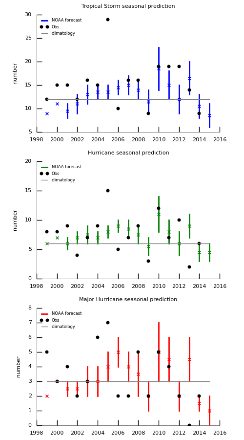
Figure 1: NOAA forecasts of number of tropical storms (blue), hurricanes (green), and major hurricanes (red) from 1999 to 2015. The cross signs indicate the mean and the black dots are the number of storms observed.
We should not take tropical cyclone seasonal prediction for granted. It is a result of improvements over time in our understanding of the atmosphere, ocean and global climate system, in observations, in numerical models and in computing power. The first peer-reviewed scientific articles on Atlantic seasonal hurricane prediction were published in the early 1980s by Dr. William Gray, who found a statistical link between seasonal hurricane frequency and the El Niño-Southern Oscillation (ENSO) phenomenon. Today, the state of ENSO–whether we are in an El Niño, La Niña, or neither–remains an essential factor in seasonal tropical cyclone prediction.
In 2015, the main reason for the below-normal prediction in the Atlantic is because we are expecting the current El Niño to persist and intensify. This is likely to increase the vertical wind shear, and induce anomalous large-scale subsidence and a more stable atmosphere over the tropical Atlantic. All those factors are unfavorable for tropical cyclones to develop. The East Pacific is a different story; El Niño tends to cause active seasons there. This year is already living up to that expectation, with two tropical cyclones, Andres and Blanca, currently spinning in the waters west of Mexico.
The Atlantic Multidecadal Oscillation, or AMO, is an index for long-term changes of sea-surface temperature in the northern Atlantic. It’s another climate predictor relevant to seasonal tropical cyclone forecasts. In the warm phase of the AMO, the sea-surface temperature in the tropical Atlantic is anomalously warm and overlain by a relatively moist and more unstable atmosphere, and vertical wind shear is weak, so we expect more active hurricane seasons. For the 2015 season, we are expecting the cold AMO phase to persist, but with large uncertainty. In addition to the current state of these various climate predictors, expected future oceanic and atmospheric conditions over the Northern Atlantic, as predicted by global climate models, are also considered in NOAA’s seasonal prediction.
How good are these seasonal predictions of tropical cyclone activity? They are not precise, to begin with. The forecasts give a significant range for the most likely values, and acknowledge a significant probability that the reality will still fall outside that range. For example, the forecast gives a 70 percent chance the observations will fall in the forecast range in 2015. In some years (e.g., 2002), the most likely probability can be below 50 percent. And sometimes, as in 2013, the forecasts are just completely wrong.
But to be more precise, the charts above plot the official seasonal predictions for the numbers of tropical storms (blue), hurricanes (green), and major hurricanes (red). In recent years, the prediction of whether the numbers are above or below the climatological average (gray lines) is pretty good, although there are some outliers. There is certainly room for improvement. I want to emphasize that I am not here to criticize the current forecasts; it’s pretty amazing that we can do seasonal prediction even as well as we can. But having some idea of the historical forecast performance can help in interpreting the forecast today.
Finally, it is important to remember that it takes only one storm to hit your town to make your life miserable for a while, so let’s get the hurricane preparation done for the season. Happy Hurricane Season!
Chia-Ying Lee is a post-doctoral researcher at the International Research Institute for Climate and Society.Her research on tropical cyclones forms a core component of the Columbia Initiative on Extreme Weather and Climate.

You must be logged in to post a comment.