IRI and U. of Arizona Team Up for Climate
IRI and the University of Arizona address climate vulnerability in most at-risk areas of the world in new project
The Caribbean, Asia’s Indo-Gangetic Plain and West Africa are three regions known to be extremely vulnerable to climate variability and change, particularly to droughts, extreme weather events and stresses on food production, water resources and coastal areas. A new five-year project jointly led by the International Research Institute for Climate and Society and the University of Arizona aims to strengthen climate resilience in these regions using strategies in the sectors of water resources, hazard risk management and coastal planning and management.
Scientists Adrian Trotman and Cédric Van Meerbeeck from the Caribbean Institute of Meteorology and Hydrology discuss the various risks climate poses to people living in the Caribbean in this brief video.
“We know that today’s climate threatens hard-won development gains made in these regions, and these threats are likely to worsen with future climate change,” says IRI Director Lisa Goddard. “Our goal is to not only help them better anticipate climate-related impacts but also to identify ways to reduce their vulnerability to such events before they occur, while also increasing their ability to bounce back if and when they’re hit with such events.”
Jim Buizer, Director of Climate Adaptation and International Development at the University of Arizona Institute of the Environment, says that with complementary expertise, the two institutions are uniquely positioned to achieve these goals.
“It’s a dream team of sorts, drawing on relative strengths of each institution. The University of Arizona, for example, brings longstanding expertise in assessing the ways in which communities around the world are vulnerable to the impacts of climate change, given socioeconomic and other factors, and in assessing climate information needs of decision makers,” says Buizer, who is leading the Arizona team on the project. “And IRI brings more than 15 years of producing scientific knowledge for the benefit of society and transforming the best understanding of the physical climate system into integrated knowledge products that are delivered and used.”
Assessing each region's vulnerabilities, information needs, capabilities and adaptation challenges.
Working with national meteorological agencies as well as regional climate centers to produce forecasts and other climate information products that serve the needs of the water, disaster response and coastal management sectors.
Using these products to develop drought early-warning systems and other types of integrated decision-support tools
Improving the system through rigorous evaluation
Building local capacity through trainings and workshops
Project web pages
About the International Research and Applications Project (NOAA)
The National Oceanic and Atmospheric Administration and the U.S. Agency for International Development are funding the project, which will kick off its first set of activities in late May 2014 in the Caribbean. It will expand to Asia in the fall of 2014, and to Africa by the end of 2015.
“This project marks the next phase of our long-term investment in international climate research and applications programs designed to foster the effective use of climate science in risk management, adaptation and development,” says NOAA’s Lisa Farrow Vaughan. “We are hoping to build upon the extensive experience and expertise of the IRI-University of Arizona team and help develop the knowledge, capacity and institutional networks to facilitate the participation of countries and regions in the global movement toward the design of climate services and early warning information systems, ensuring that they are of practical use for stakeholders.”
While each of the regions already have national meteorological services and regional climate centers capable of delivering weather and climate information, most of these institutions would like to improve their understanding of vulnerabilities to climate change and to expand the scope and quality of the information they provide.
In the Caribbean, for example, the team from IRI and University of Arizona have begun working with regionally focused institutions such as the Caribbean Institute for Meteorology and Hydrology and the Caribbean Community Climate Change Centre, as well as national weather services and research programs within the University of the West Indies system.
An early product to come out of the new project is a prototype collection of interactive data maps useful for analyzing climate specifically in the Caribbean region. Based on IRI’s existing Map Room format, this online tool lets decision makers and other users view and perform calculations on historical, current and future climate conditions. They can download the data and maps in a variety of formats including Google Earth and ArcGIS, as well as share their analyses via social media and other online networking platforms.
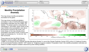
A prototype collection of interactive data maps to help decision makers and other users analyze climate in the Caribbean region.
The two institutions will host a workshop in Kingston, Jamaica at the end of the month that will occur in conjunction with a regional climate outlook forum. The aim is to engage the climate community and their stakeholders in discussions on climate-related vulnerabilities and information needs that will motivate much of the collaborative research in the region over the course of the project.
“The goal over the next five years is to make solid progress in the ways in which the most vulnerable communities in the Caribbean, Asia and Africa understand and manage their risks and increase their resilience to impacts of climate variability and change,” says USAID’s John Furlow.
For Goddard, the project also represents a continuation of NOAA’s investment in internationally focused climate research and of IRI’s role in promoting the agency’s climate science and information products for decision making, management and planning support.
“In addition, having USAID’s backing and support also helps ensure the science will inform and connect to international development and climate-change adaptation investments,” she says.
You must be logged in to post a comment.