CCSR/IRI ENSO Forecast
CCSR/IRI Technical ENSO Update and Model-Based Probabilistic ENSO Forecast
Published: September 21, 2026
ENSO Current State: Ocean–Atmosphere Overview
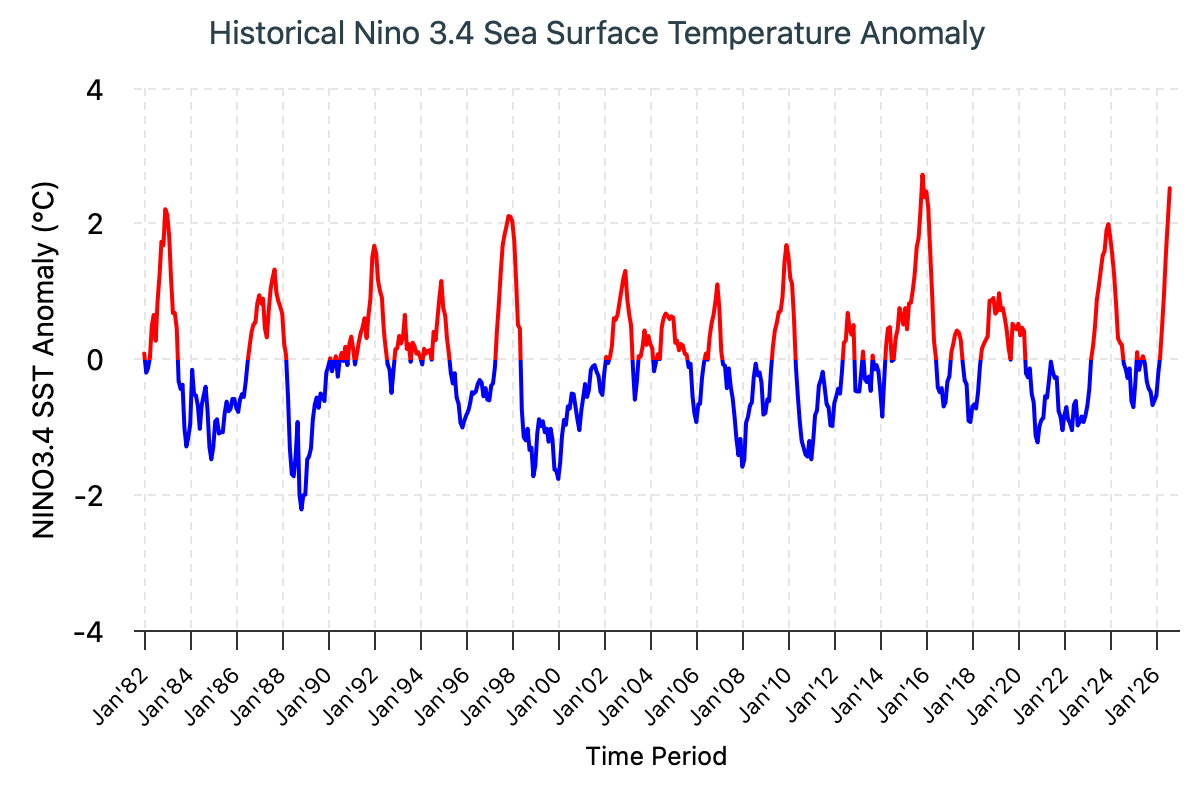
The 2026 El Niño event continues to intensify across the central and eastern equatorial Pacific. The traditional Niño 3.4 index shows a pronounced and sustained rise, with the seasonal mean reaching +2.03°C during June–August 2026 and the August monthly value increasing further to +2.52°C. The latest weekly Niño 3.4 index, centered on September 16, 2026, climbed to +3.0°C, providing further evidence that El Niño is already very strong and continuing to strengthen.
Oceanic and atmospheric indicators are increasingly aligned, providing compelling evidence that the ongoing El Niño event will continue to intensify. On the atmospheric side, the Southern Oscillation Index (SOI) reached −14.6 in August 2026, while the latest 30-day SOI value, through September 16, remained strongly negative at −20.1. These persistently negative SOI values indicate a pronounced weakening of the Walker circulation, consistent with ongoing El Niño. In addition, the Equatorial SOI reached −2.5 in August 2026, further indicating that the atmosphere is responding to the warming Pacific Ocean. The spatial pattern of convection and winds further reinforces this atmospheric response. Enhanced convection and precipitation extended across the equatorial Pacific from the Date Line to the eastern Pacific, while suppressed convection persisted over the southern Philippines, Indonesia, and Papua New Guinea. Low-level westerly wind anomalies extended from the western to east-central equatorial Pacific, with easterly anomalies farther east. At upper levels, easterly anomalies prevailed across the western and east-central Pacific, while westerly anomalies emerged over the far-eastern Pacific, together forming a circulation pattern consistent with a strengthening El Niño. Together, these signals provide strong evidence that ocean–atmosphere coupling associated with El Niño is firmly established.
Further proof of the strengthening major El Niño comes from the subsurface ocean. An exceptionally warm reservoir has developed across the central and eastern equatorial Pacific, with subsurface temperatures at approximately 50–150 m between 150°W and 80°W exceeding climatological values by more than 8°C. This exceptional subsurface warming is also reflected in the far eastern Pacific, where the Niño 1+2 index has remained persistently above +4°C for the past six weeks, indicating extraordinarily warm conditions along the South American coast. This substantial subsurface heat content provides a large reservoir of energy for continued surface warming and further El Niño intensification, particularly as favorable ocean–atmosphere coupling continues. In tandem, subsurface cooling is evident at approximately 100–250 m in parts of the western Pacific, from around 140°E toward the Date Line, although the anomalies there are considerably weaker. The stark contrast between the exceptionally warm central–eastern Pacific and the weaker or negative oceanic anomalies farther west provides strong evidence of a major redistribution of subsurface ocean heat associated with the ongoing El Niño. The magnitude and spatial extent of this warming raise the potential for further increases in surface temperature anomalies through the boreal fall and winter. If this evolution continues, the 2026 El Niño could rank among the strongest events in the historical ENSO record.
ENSO Strength
Forecasts of ENSO strength are estimated through a consensus-based model counting approach using a set of Niño 3.4 sea surface temperature anomaly thresholds, to indicate weak, moderate, strong and very strong El Nino and La Nina categories.
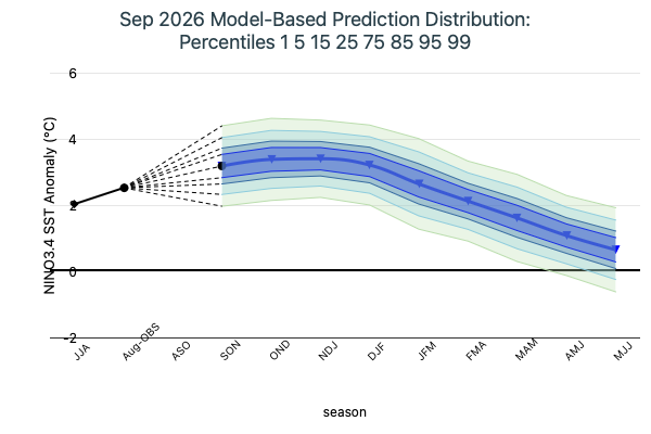
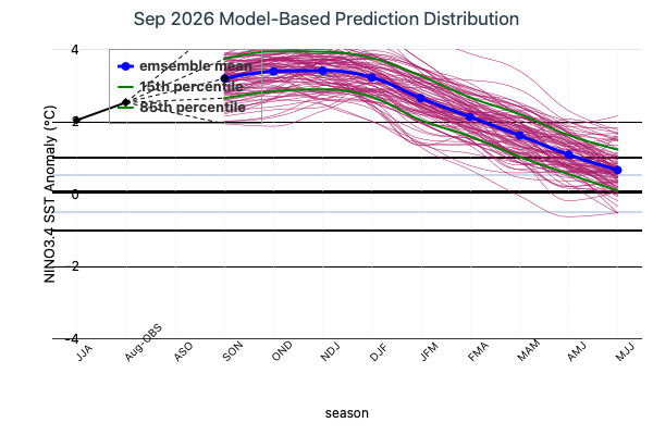
The mid-September 2026 intensity assessment provides a striking indication of the exceptional strength of the ongoing El Niño event. The model ensemble points to an exceptionally strong 2026-27 El Niño, with all 22 models forecasting a “very strong” El Niño (Niño 3.4 ≥ +2.0 °C) from SON 2026 through DJF 2026–27. Our current intensity classification is capped at +2.0°C, yet a majority of models in the plume—including both dynamical and statistical models—project Niño3.4 values that could reach or exceed +3.0°C, well beyond our highest defined category. This is more than a high-probability El Niño: the ensemble shows an unusually strong and consistent signal for an event of exceptional intensity. Although the forecast shifts toward weaker categories in early 2027, strong-to-moderate El Niño conditions remain through MAM 2027, underscoring the unusual magnitude and persistence of the 2026 event. Taken together, the mid-September objective ENSO outlook points to an exceptionally strong El Niño that will remain firmly established through the end of 2026 and persist into spring 2027.
Notes:
The SST anomalies cited below are based on the NOAA Optimum Interpolation Sea Surface Temperature (OISSTv2)dataset. The climatology period is 1991–2020.
The primary metric used to monitor the El Niño–Southern Oscillation (ENSO) is the traditional Niño3.4 index (TONI), defined as the area-averaged sea surface temperature anomaly over the Niño3.4 region (5°S–5°N, 170°W–120°W).
According to the CCSR/IRI definition, El Niño conditions occur when monthly TONI exceeds +0.5 °C, while La Niña conditions occur when monthly TONI falls below −0.5 °C.
An ENSO “event” is considered established when the TONI threshold (±0.5 °C) persists for at least five consecutive overlapping 3-month seasons (e.g., SON, OND, NDJ, DJF, JFM).