New Climate Services Program in Rwanda Aims to Reach One Million Farmers
The Rwanda Climate Services for Agriculture project, officially launched on #WorldMetDay 2016, will benefit nearly one million farmers over the next three years and reshape national food-security planning for the long term.
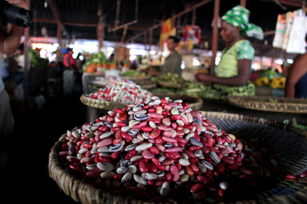
Fresh beans on sale in a Rwandan market. Credit: Stephanie Malyon / CIAT
(Kigali, Rwanda) 23 March 2016. To build a more climate-resilient agriculture sector, the Rwandan government and partners are taking action to provide nearly a million farmers timely access to essential climate information services. The Rwanda Climate Services for Agriculture project will ultimately help transform Rwanda’s rural farming communities and national economy through improved climate risk management. The project builds on ongoing innovations made by IRI’s Enhancing National Climate Services initiative (ENACTS), which filled in a 15-year gap in Rwanda’s historical meteorological records.
Agriculture contributes to one-third of Rwanda’s gross domestic production and remains the main source of subsistence for the majority of the country’s population. Farming employs eight out of ten Rwandans. Despite its importance, the sector remains highly vulnerable to current and projected climate and weather variability. Severe flooding in 2007, for example, caused an estimated US$22 million in two districts alone. Recurrent hail and wind storms, heavy rains and prolonged droughts take frequent tolls on agricultural productivity. Such weather events are expected to become more frequent and intensive with climate change, posing a threat to food security.
“In this context, it becomes critical that farmers can access and use reliable climate and weather forecasts,” said Innocent Bisangwa, an environmental and climate change specialist in Rwanda’s Ministry of Agriculture and Animal Resources (MINAGRI). “Through this work, we will help them make the best decisions about when and what to plant, how much fertilizer to apply and when to harvest,” he said.
The new project addresses two critical issues: reconstructing Rwanda’s incomplete meteorological data record using cutting-edge climate science, and developing climate information products and services based on the expressed needs of farmers and other end users.
The work is carried out by the Rwanda Agriculture Board (RAB) and Meteo Rwanda, in collaboration with the the CGIAR Research Program on Climate, Agriculture and Food Security (CCAFS), the International Research Institute for Climate and Society (IRI) at Columbia University, the International Center for Tropical Agriculture (CIAT), the World Agroforestry Centre (ICRAF), and the International Livestock Research Institute (ILRI), with funding from the United States Agency for International Development (USAID).
“We’re very excited about this project and what it plans to achieve in the next 4 years,” said Malick Haidara, the director of USAID Rwanda’s Economic Growth Office, during the official launch. “We believe it’s transformative.”
A Generation of Missing Data
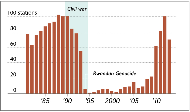
This chart shows the number of operational weather stations in Rwanda
The missing data traces its origins in tragedy. The 1990-1994 civil war and genocide in Rwanda led to a catastrophic disruption of Rwanda’s meteorological observation network. Most of the country’s weather stations had been destroyed, looted or rendered inoperable. A decade later, only few stations had been brought back online. It was not until 2010 that Rwanda’s National Meteorological Agency restored its pre-1994 number of stations.
“We had to address this 15-year gap in our meteorological records,” said Didace Musoni, from Meteo-Rwanda. “This was not an abstract problem: the absence of such data has had significant impact on society here,” he said.
“A lack of historical data means we cannot get an accurate baseline definition of weather in a ‘normal’ season, which means seasonal forecasts are going to be less accurate,” said Tufa Dinku, a research scientist at IRI who leads the ENACTS work. “For example, if forecasts call for ‘above-normal’ rainfall for the growing season, what does that really mean? The scale of the data problem in Rwanda is something we hadn’t encountered in other countries,” Dinku said.
Dinku lists a number of questions that are difficult to answer without solid historical data: How is climate change unfolding in the country? Are there certain areas seeing more impacts than others? What is the year-to-year variability in rainfall and how has that changed? What has been the trend between climate and agricultural productivity? Even the impacts of El Niño would be poorly known.
The 1997/98 El Niño had massive, wide ranging consequences over eastern Africa. At that time, Rwanda had only 3 or 4 weather stations measuring data. Even in a small country like Rwanda—which is the size of Massachusetts—the effects of El Niño vary.
When countries in the region were trying to prepare for the 2015 El Niño, they naturally looked at the rainfall and temperature patterns of 1997 for comparison. “Kenya, Tanzania, Ethiopia all did that,” says Dinku. “But it would have been difficult in Rwanda, because there was so little information.”
ENACTS changed the situation by bringing in global satellite technology and climate-model products. For decades, satellites have been continuously monitoring rainfall, temperature and other climate variables over most of the world at high resolution.
Using that ENACTS approach, Meteo-Rwanda has filled in the missing data by blending whatever on-the-ground measurements existed with the global products. As a result, Rwanda now has more than 30 years of rainfall and temperature data every 5-km across the whole country.
“There are now no gaps in the record, and this opens up a whole world of opportunities for us,” said Musoni.
Dinku adds that the focus of ENACTS isn’t just on improving quality of the data, but also on improving access to data and its use. He has worked closely with Meteo-Rwanda, organizing trainings to ensure its staff understand how to work with the new data. Members of the IRI’s Data Library team have also helped install maprooms that allow anyone to visualize and download the products.
Robust, Science-based and User-informed Climate Services
“Rebuilding the data sets the foundation for developing the kinds of information products we know are useful to farmers and other decision makers,” explained James Hansen, Program Leader for the CCAFS flagship on managing climate risk. “These include forecasts by SMS and radio, which now reach millions of rural people in countries such as Senegal,” he said.
The new Rwanda Climate Services for Agriculture project will build on the ENACTS innovations to improve agricultural planning and food security management in the country at all levels.
“The goal is to develop the government’s capacity to provide location-specific, climate information that is relevant for decision makers, while also developing the capacity of agriculture extension workers to bring that kind of information to farmers and assist them in incorporating it into their planning,” says Bisangwa.
“We had to address this 15-year gap in our meteorological records. This was not an abstract problem: the absence of such data has had significant impact on society here.”
-Didace Musoni, Meteo-Rwanda
A key success factor is involving farmers from the beginning, and ensuring their knowledge is built into these initiatives. The project will use a tried and tested approach known as PICSA—Participatory Integrated Climate Services for Agriculture – to help farmers understand how climate information could impact their own decision making.
The project aims to deliver four specific outcomes:
- Climate Services for Farmers. Farmers across Rwanda’s 30 districts will have decision-relevant, operational climate information and advisory services, and be trained to use the information to better manage risk.
- Climate Services for Government and Institutions. Agricultural and food security decision makers in the Ministry of Agriculture and other national and local government agencies and institutions will use climate information to respond more effectively to risks.
- Climate Information Provision. Meteo-Rwanda will design, deliver, and incorporate user feedback into a growing suite of weather and climate information products and services tailored to the needs of decision makers.
- Climate Services Governance. A national climate services governance process will oversee and foster sustained coproduction, assessment and improvement of climate services.
“Rwanda is showcasing what can be done with climate services, even when you have an enormous gap in observational records,” said Hansen. “It’s the only country in Africa as far as we know with an official ‘open data’ policy and it’s poised to lead the continent in making not just forecasts but data a public good and a resource for development.”
—
The International Research Institute for Climate and Society (IRI), part of the Earth Institute at Columbia University, aims to enhance society’s ability to understand, anticipate and manage the impacts of climate in order to improve human welfare and the environment, especially in developing countries. Visit iri.columbia.edu and follow @climatesociety on Twitter.
The CGIAR Research Program on Climate Change, Agriculture and Food Security (CCAFS), led by CIAT, brings together the world’s best researchers in agricultural science, development research, climate science and Earth System science, to identify and address the most important interactions, synergies and tradeoffs between climate change, agriculture and food security. Visit www.ccafs.cgiar.org and follow @cgiarclimate on Twitter
You must be logged in to post a comment.