June 2014 Climate Briefing: El Niño Likely to Develop this Summer
From the June climate briefing, given by IRI’s Chief Forecaster Tony Barnston:
Tony Barnston provides an overview of the briefing
Changes from last month’s briefing
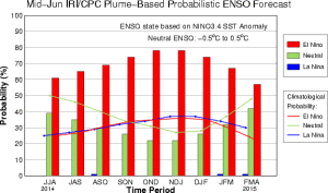
The IRI/CPC probabilistic ENSO forecast issued mid-June 2014. Note that bars indicate likelihood of El Niño occurring, not its potential strength. Unlike the official ENSO forecast issued at the beginning of each month, IRI and CPC issue this updated forecast based solely on model outputs. The official forecast, available at http://1.usa.gov/1j9gA8b, incorporates human judgement.
As the northern hemisphere summer gets underway, the El Niño Southern Oscillation (ENSO) shows signs of borderline neutral/weak El Niño conditions in the equatorial Pacific. However, conditions in the atmosphere remain ENSO-neutral. The Niño3.4 sea-surface temperature anomaly was +0.4ºC last week, just shy of the +0.5ºC threshold indicative of El Niño conditions and 0.1ºC lower than the anomaly seen in early May.
The IRI’s June ENSO forecast predicts a 60% chance of El Niño developing during the current June-August season, and a 75-80% chance by mid-autumn. These probabilities are a slight increase from the IRI’s May forecast, but marginally lower than NOAA/IRI’s forecast issued June 5.
The main reason these probabilities have not increased is the lack of atmospheric involvement in response to the ocean and in further nudging the ocean toward an El Niño state. Sea surface temperature anomalies are strongly positive in the eastern Pacific, which has already caused El Niño-like weather impacts along the coast of Peru. However, the Niño3.4 anomalies remain closer to normal compared to the warmer western and eastern portions of the Pacific basin.
The lack of a gradient in sea surface temperature anomalies is discouraging development of steadier wind flow from Indonesia from pushing the warm waters of the western Pacific eastward, which would be expected during developing El Niño conditions.
Although the atmosphere is lagging behind the El Niño-like sea surface temperature pattern, Chief IRI Forecaster Tony Barnston expects a stronger atmospheric response in the next one to three months. “Many El Niño events develop this way, where the atmosphere takes longer than the ocean to play ball,” he said.
While the likelihood of an El Niño developing by mid-autumn has increased, model forecasts are still uncertain about the strength of the event. Most models are predicting a moderate El Niño, with a slightly greater chance of a weak event than a strong one.
Effects of El Niño on global seasonal climate forecasts
Each month, IRI issues seasonal climate forecasts for the entire globe. These forecasts, which take into account the latest ENSO projections, indicate which areas are more likely to see above or below normal temperatures and rainfall. The latest forecasts show a moderate to high climate impact in areas most directly affected by ENSO events.
For the upcoming July-September season, Barnston noted there is a “strong tilt of the odds toward low precipitation in Indonesia and northern South America” compared with IRI’s May forecast. During the northern hemisphere autumn, above-normal rainfall is likely in southeastern South America and the greater Horn of Africa.
Scientists should know more each month about the chances for El Niño, its potential strength, and the climate impacts. Sign up here to get notified when the next forecast is issued, and in the meantime, check out #IRIforecast or use #ENSOQandA on Twitter to ask your El Niño questions. Our ENSO page has background information on links to our current forecasts.
You must be logged in to post a comment.