El Niño Odds Reduced
From the January climate briefing, given by IRI’s Chief Forecaster Tony Barnston:
Tony Barnston provides an overview of the briefing
Changes from last month’s briefing
Based on the latest models, the chance of an El Niño developing during the current (January – March) season is around 63%, down from 76% last month. These odds for the current season are similar to those issued by the NOAA Climate Prediction Center/IRI forecast on January 8.
In the week leading up to the briefing, sea-surface temperatures (SSTs) in the Nino3.4 region (see image) were 0.4ºC above average. This is the first time since October that a weekly average has dipped below the +0.5ºC threshold considered to indicate El Niño conditions. The weekly temperature averages, however, are a relatively “instantaneous” measurement, so uncertainty about an El Niño event remains. The National Oceanic and Atmospheric Administration will only declare an El Niño event if +0.5ºC SST conditions are sustained for the next two or three months.

The recent dip in sea-surface temperatures could be indicating an end to the El Niño conditions forecasted for much of the past year. Despite signals of an emerging El Niño from the ocean and atmosphere at various times throughout 2014, the systems of the sea and sky have yet to couple, which is required for a sustained ENSO event. The lack of convection (i.e. cloudiness and rainstorms) in the equatorial Pacific has been and remains a major missing component of El Niño.
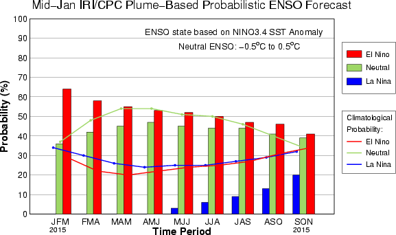
The IRI/CPC probabilistic ENSO forecast issued mid-December 2014. Note that bars indicate likelihood of El Niño occurring, not its potential strength. Unlike the official ENSO forecast issued at the beginning of each month, IRI and CPC issue this updated forecast based solely on model outputs. The official forecast, available at http://1.usa.gov/1j9gA8b, incorporates human judgement.
Effects of El Niño on global seasonal forecasts
 Each month, IRI issues seasonal climate forecasts for the entire globe. These forecasts take into account the latest ENSO SST projections and indicate which areas are more likely to see above or below normal temperatures and rainfall. For the March-May period, the forecast continues to show a strong likelihood of drier-than-normal conditions over Indonesia, and some enhanced likelihood of dry weather in northern South America (image right). Wetter-than-average conditions are somewhat more likely in the southwestern United States.
Scientists should know more each month about the chances for El Niño, its potential strength, and the climate impacts. Sign up here to get notified when the next forecast is issued, and in the meantime, check out #IRIforecast or use #ENSOQandA on Twitter to ask your El Niño questions.
You must be logged in to post a comment.