|
IRI Climate Digest
March 2001
October-December 2000 Seasonal Forecast & Observations
Date and Period of Forecast
In September 2000, the IRI
prepared a Climate Outlook for October 2000 - March 2001.
Here we provide a subset of the September Net Assessment Forecast
with observed rainfall percentiles for the same period for qualitative
comparison. A complete formal validation of these forecasts will appear
on the IRI website at a later date.
The complete forecast and observation maps for October-December 2000,
in addition to the current forecast for January-June 2001,
can be found at http://iri.columbia.edu/climate/forecast/net_asmt/.
Uncertainties
This Climate Outlook is dependent on the quality of the
sea surface temperature (SST) predictions.
For the tropical Pacific, these predictions can be expected to provide
useful information, but there is some uncertainty concerning the detailed
evolution of SSTs. Spread in global SST predictions is a source
of uncertainty in the Outlook provided here. The procedures, models,
and data used to derive this Climate Outlook may be somewhat different
from those used by National Meteorological Services in particular
regions and may differ from the official forecasts issued in those areas.
Regional Influences
The current status of seasonal-to-interannual climate
forecasting allows prediction of spatial and temporal averages,
and does not fully account for all factors that influence regional
and national climate variability. This Outlook is relevant only
to seasonal time scales and relatively large areas;
local variations should be expected. For further information
concerning this and other guidance products, users are strongly
advised to contact their National Meteorological Services.
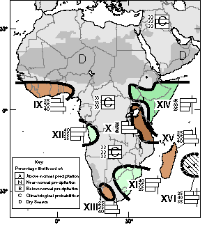
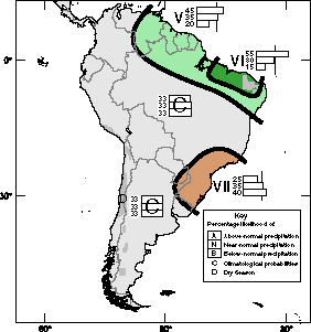
Precipitation Outlook
The Outlook for October-December 2000 can also be
found at
http://iri.columbia.edu/climate/forecast/net_asmt/.
Maps show expected precipitation probabilities
in tercile classes. The maps indicate probabilities that
seasonal precipitation will fall into the wettest third
of the years (top number), the middle third of years (middle number)
or the driest third of the years (bottom).
An outlook of climatology "C" (light grey)
indicates equal probabilities in each class; i.e., there is no
basis for favoring the forecast of any particular category.
Areas marked "D" (dark grey) experience a pronounced dry season during
the forecast period, typically receiving less than 15% of their annual
precipitation or less than 5 cm total during this three-month period.
Boundaries between sub-regions should be considered transition zones,
and their location considered to be only qualitatively correct.
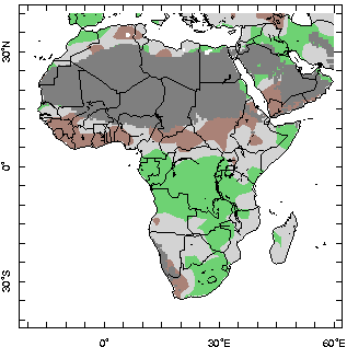
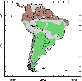
October-December 2000 Precipitation Probabilities and Observed Precipitation Anomalies. Precipitation anomalies are shaded ONLY for "above-normal" (above 67%-ile) and "below-normal" (below 33%-ile).
October-December 2000 Precipitation Probabilities and Observed Precipitation Anomalies. Precipitation anomalies are shaded ONLY for "above-normal" (above 67%-ile) and "below-normal" (below 33%-ile).
Ocean Conditions
Of relevance in the preparation of this Outlook were the
near-average sea-surface temperatures
(SSTs)
in the central equatorial Pacific Ocean.
Near neutral equatorial Pacific SST conditions were in effect,
October-November-December 2000.
The SSTs of the tropical Indian Ocean were assumed to remain normal.
Tropical Atlantic SSTs were expected to be above-normal during the first
forecast season and were expected to return toward normal during
the second season.
Methods
The following procedures and information were used to
prepare this Climate Outlook:
- Coupled ocean-atmosphere model predictions of tropical Pacific SST --
particularly heavy weighting has been given to the NOAA /NCEP, Climate Modeling Branch coupled model
- Statistical forecasts of Indian Ocean and Atlantic Ocean sea surface temperature
- The response of Atmospheric global circulation model (GCM) predictions to
the present and predicted SST patterns
- Statistical analyses
- Appropriate Regional Climate Outlook Forum consensus guidance.
|
Sources of information include ACMAD,
COLA, CPTEC, CPC/NOAA, CMC, Department of Natural Resources (Queensland,
Australia), NIWA, ECMWF, Indian Meteorological Department, PAGASA, Bureau
of Meterology, and the South African Weather Service.
|
Contents |
Impacts |
Climate |
Forecast |
Special
|