|
IRI Climate Digest
June 2006
Climate Impacts - May
Contributions to this page were made by IRI researchers
M. Bell,
Dr. A. Giannini,
E. Grover-Kopec,
Dr. B. Lyon,
C. Ropelewski
Africa
Hazards - Africa: East
Many areas in East Africa, portions of which are struggling to recover from severe drought conditions, experienced another month of beneficial rainfall during May (May 2006 CID). As in April, however, the rainfall brought flooding to some areas. In Kenya, the provinces of Coast, Nyanza and Western were among those worst affected by the flooding. Approximately 10,000 and 3,000 people were displaced by flooding in the districts of Wajir and Kilifi, respectively, and eight deaths were reported between 25 April and 4 May in the districts of Samburu and Migori. (IRIN, FEWSNet) At least 19,000 people were left homeless after flooding affected portions of the Kilimanjaro region in northern Tanzania. Hundreds of livestock and at least 1459 hectares of crops were lost as well. (IRIN, IFRC, IFRC Map)
While the rainfall is expected to bolster pasture and crops in the short term, much of the region will continue to feel the effects of the recent drought for quite some time (IRIN, Apr 2006 CID). In Djibouti, approximately 70,000 people are expected to need food aid until November. Food insecurity is expected to remain prevalent in the Somali region of Ethiopia as well, which, in contrast to many neighboring areas, did not receive good rainfall during recent months. (IRIN) The drought-related humanitarian emergency in southern Somalia has been exacerbated by recent fighting in Mogadishu, which has disrupted market supplies throughout the region. At least 17 percent of the Somalia's 10 million inhabitants are currently affected by drought. (Reuters)
The latest IRI seasonal forecast for the upcoming July-September season indicates a slightly enhanced probability of above-normal precipitation in Djibouti and the northern two-thirds of Ethiopia.
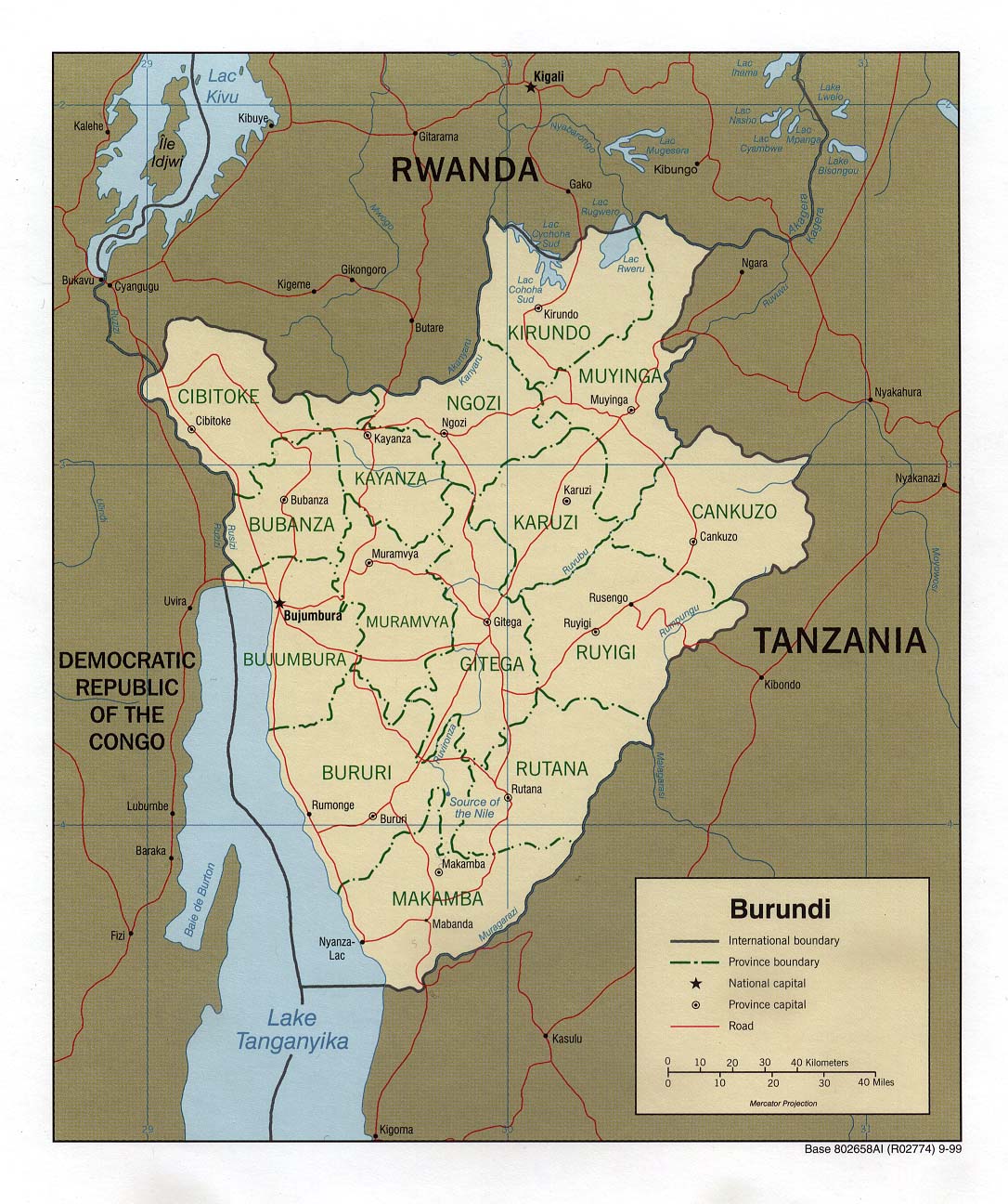
Hazards - Burundi
A series of storms since mid-April has caused wind and flood damage to property and crops and several deaths throughout Burundi. According to IRIN, heavy rainfall in mid-April (April 2006 Precipitation Percentile Map) caused landslides in many provinces. In the central province of Muramvya, eleven people were reportedly killed, 1,800 hectares of crops were damaged and at least 200 homes were destroyed. Storms in April also left at least 1200 people homeless in the northwestern province of Cibitoke after 160 homes were destroyed (IRIN). Hundreds of hectares of crops including beans, cassava, maize, and sweet potatoes were lost as well. In May, persistent rainfall again in the northwestern part of the country caused additional flooding in Cibitoke province as well as the province of Bubanza, where it led to nine deaths, the destruction of 240 homes, and livestock losses, principally in Gihanga commune. Landslides also blocked roads in Bujumbura Rural province (IRIN). Finally, additional flooding in May in the Muheka commune of Bururi province in southern Burundi, destroyed crops and 206 homes, leaving at least 5,000 people homeless. The government of Burundi has recently started to distribute 18 tonnes of food aid to thousands of people that were affected by the flooding in the province of Bubanza. (IRIN)
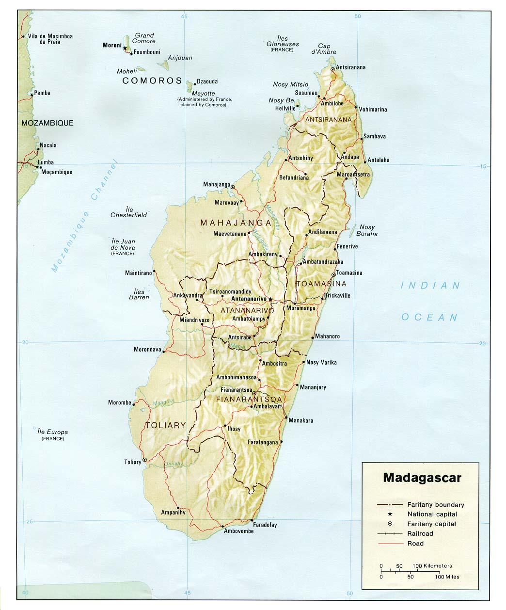
Agriculture - Madagascar
A series of calamities in recent years, including drought and cyclone damage (Dec 2002 CID, Mar 2003 CID, Jun 2003 CID, Dec 2005 CID), has contributed to the chronic food security problem in southern Madagascar. On top of this already vulnerable situation, the poor performance of the October 2005 - March 2006 rainy season (Oct-Mar 2006 6-month WASP Index) has led to warnings from WFP and USAID that developing drought conditions may lead to crop failures in southern Madagascar and worsen the food security situation (IRIN, FEWS Net). The rainy season there ended about six to eight weeks earlier than normal (Mar 2006 Precipitation Persistence Map), and precipitation earlier in the rainy season was reportedly quite irregular. The warnings note specifically that the poor rains in twenty-one counties in the southwestern province of Tulear may affect the food security of over 300,000 people living there (WFP).
Asia
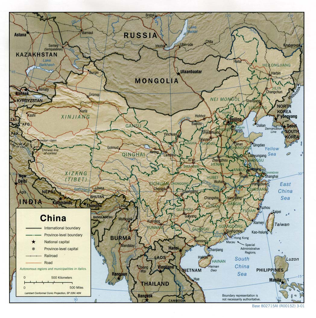
Agriculture - China
Winter crops in the North China Plain are feeling the effects of drought conditions. The provinces of Ningxia, Inner Mongolia and Hebei are among those most affected (Reference Map). Abnormally warm conditions during boreal spring and long-term dry conditions have caused soil moisture levels to decrease (12-month WASP Index Map, Feb-Apr 2006 Temperature Anomaly Map). Approximately 5 million hectares of winter crops in the region, which typically accounts for 38% of China's total winter wheat production, has been lost or damaged. In Ningxia, where some districts have not received any rainfall for more than 600 days, 40-60% of the winter wheat crop was lost and only 30% of the planned spring crops were planted. Water resources in the region have been affected by the drought as well. Hundreds of reservoirs have gone dry and tens of thousands of wells are threatening to do the same. (NASA, FAS/USDA, FAO/GIEWS)
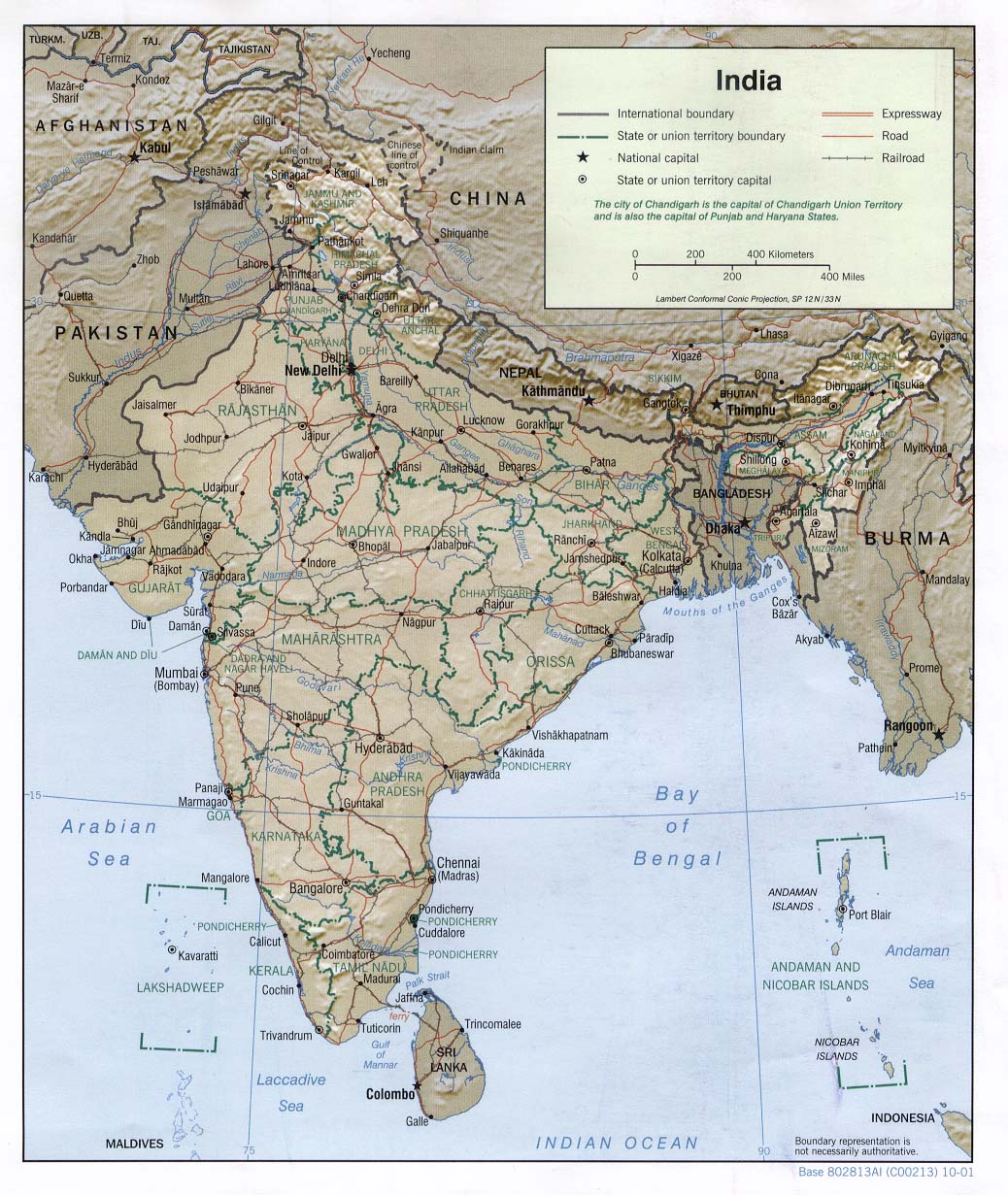
Health - India
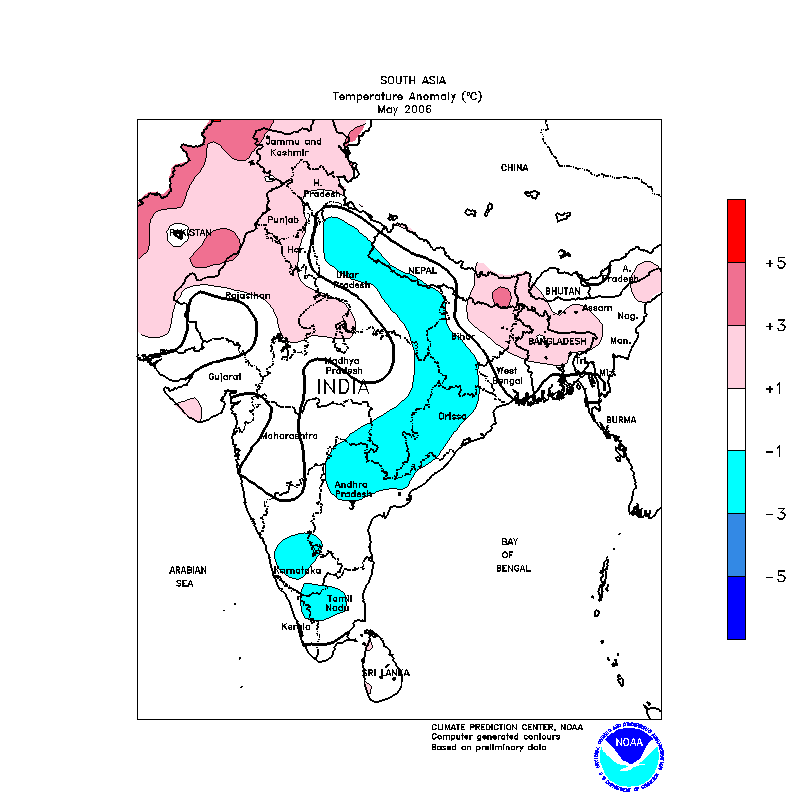
Ahead of the onset of the Indian monsoon, which typically occurs around early June, temperatures in India usually reach their annual maximum value. It is not unusual to see daily maximum temperatures reach above 45�C (113�F) at this time of year and cause a large number of heat-related deaths. This year has been no different. During much of April and early May, daily mean temperature anomalies as large as 5�C above normal were found at several stations in northern India. At the same time, many cities have experienced electricity outages and water shortages. By early May, 47 temperature-related deaths had been reported in the states of Orissa, Punjab, Uttar Pradesh, Bihar, and Haryana (Reference Map; AFP). Beginning around the middle of May, daily temperature departures as much as 6�C below normal brought some relief to sections of northern India (IBNLive.com) in a swath from Uttar Pradesh to Orissa, which is reflected in the monthly anomalies (CPC May 2006 Temperature Anomaly Map). Still, as of early June, the heat wave had reportedly caused 60 deaths in Uttar Pradesh alone (newKerala.com).
In the state of Kerala in southwestern India, the onset of the monsoon reportedly occurred about six days early (AFP). Some unusually early storms at the beginning of the monsoon season have killed as many as 105 people in the states of Maharashtra, Jharkhand, Uttar Pradesh, Gujarat, West Bengal, and Kerala (AFP).
Heavy rains (May 2006 WASP Index Map) and flooding in late May and the first days of June in the city of Mumbai disrupted road and rail traffic but did not cause damage on the scale seen last July, when torrential rainfall left 400 people dead (August 2005 CID).
The latest IRI seasonal forecast indicates a slightly-enhanced probability of near-normal precipitation and a slightly-enhanced probability of below-normal precipitation along the central coast of western India during July-September 2006, which includes the bulk of the southwest monsoon season.
Agriculture - Tajikistan
Heavy rainfall caused flooding and landslides in southwestern Tajikistan during late April and early May, which typically coincides with the end of the rainy season in that region (April-May Precipitation Animation). One death was reported and more than 3000 hectares of cotton crops and transportation infrastructure were damaged in the Khatlon oblast. Most of this damage was in the districts of Yavan, Khorasan, Dangara, Muminabad, Shurabad and Temur-Malik. The largest landslide of the event buried a section of water pipeline in the district of Rogun, leaving 13,000 people in the village of Qadi Ob without access to clean drinking water. These types of events are relatively common in Tajikistan, which is characterized by mountainous terrain and routine seismic activity and experiences more than 50,000 landslides per year. (IRIN, OCHA, ReliefWeb Map)
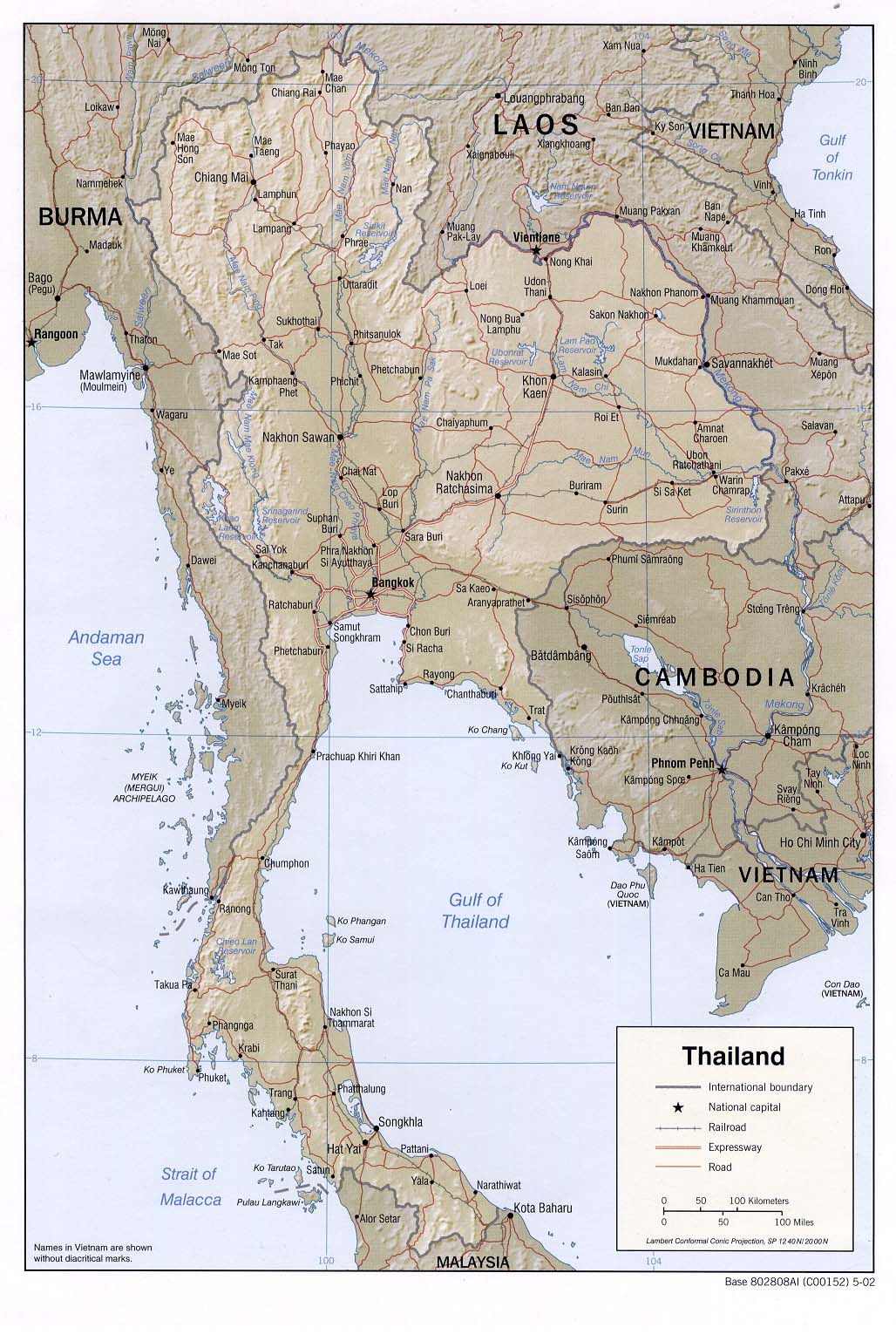
Hazards - Thailand
A few days of heavy rainfall that began on 21 May (Animation of Daily Precipitation Estimates) triggered damaging flash floods and landslides in five provinces in northern Thailand. At least 340,000 people in the provinces of Nan, Phrae, Lamphang, Uttaradit, and Sukhothai were affected (OCHA Map), and as of early June, 83 deaths had been reported and 33 people were still missing (OCHA). Approximately 700 houses were destroyed, and over 1000 roads and bridges were damaged. Initial damage estimates by the Thai government, which excluded damage to personal property, have been set at approximately USD 8 million (OCHA). Power and water service were temporarily cut in some locations, and rail service to the northern part of the country was temporarily suspended because tracks were covered by mud and water (BBC, BBC). The rains came at the beginning of the May to October monsoon season (Animation of Monthly Precipitation Climatology).
North America
Hazards - United States: Northeast
Days of persistent rainfall (Daily Precipitation Animation) led to near-record accumulations of more than 12 inches (30 cm) in the U.S. states of Maine, New Hampshire, and Massachusetts (Reference Map) in mid-May, resulting in the worst flooding in the region since the 1930s. The governors of all three states asked for disaster declarations from the federal government to gain access to federal assistance. "Thousands" of people were evacuated from their homes in New Hampshire, thousands of homes and major roadways were flooded, and sewage systems failed. Initial estimates placed damages at about USD 7 million in Maine, and in the tens of millions of dollars in Massachusetts. Due to low participation in the region in the federal flood insurance program, reimbursements from the program are expected to be "relatively small". Some of the worst flooding was along the Merrimack River in New Hampshire and Massachusetts, where industrial shops that supply the medical device industry in the area are expected to sustain large losses (Insurance Journal). It is also feared that the surge of freshwater runoff into coastal marine ecosystems may have affected some fish species and other marine life that require salinity levels within a certain range (AP).
(BBC, International Herald Tribune, AP, DFO)
South America
Agriculture - Suriname
Flooding characterized as "the worst in memory" (PAHO) caused by heavy rainfall in May, near the height of the December to August rainy season (Precipitation Climatology Animation), affected parts of Suriname for much of the month. Locations along several major rivers, including the Upper-Suriname, Tapanahoni, Lawa, and Marowijne Rivers in the Sipaliwini and Brokopondo Districts were among the areas hardest hit (OCHA, MapAction Map). The flooding displaced approximately 20,000 to 25,000 people, caused a large but poorly estimated amount of damage to agriculture, and is expected to result in shortages of food and clean water among those affected for the next two months (OCHA, IFRC). Reports noted, however, that people in the affected areas have an excellent capacity to cope with flooding events, which occur frequently.
The latest IRI seasonal forecast suggests a slightly enhanced probability of above-normal precipitation in Suriname during the July-September 2006 season.
Contents |
Special |
Impacts |
Climate |
Forecast
|
