
GEOGRAPHY |
|
GEOGRAPHY |
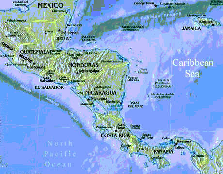

Location:
Middle America, bordering the Caribbean Sea and the Gulf
of Mexico, between Belize and the US and bordering the North Pacific Ocean,
between Guatamala and the US
Select another topic,
country
or go to the Top
|
|
|
|
|
|
|
|
|
|
Comparative area:
Slightly less than three times the size of Texas
|
|
|
|
|
|
|
|
|
|
Maritime claims:
|
|
|
|
|
|
|
|
|
|
International disputes:
claims Clipperton Island (French possession)
Climate:
varies from tropical to desert
Select another topic,
country
or go to the Top
Terrain:
high, rugged mountains, low coastal
plains, high plateaus, and desert
Natural resources:
petroleum, silver, copper, gold, lead, zinc, natural
gas, timber
|
|
|
|
|
|
|
|
|
|
|
|
|
|
current issues:
natural fresh water resources scarce and polluted in
north, inaccessible and poor quality in center and extreme southeast; raw
sewage and industrial effluents polluting rivers in urban areas; deforestation;
widespread erosion; desertification; serious air pollution in the national
capital and urban centers along US-Mexico border
natural hazards:
tsunamis along the Pacific coast, destructive earthquakes
in the center and south, and hurricanes on the Gulf and Caribbean coasts
international agreements:
party to - Biodiversity, Climate Change, Endangered Species,
Hazardous Wastes, Law of the Sea, Marine Dumping, Marine Life Conservation,
Nuclear Test Ban, Ozone Layer Protection, Ship Pollution, Wetlands, Whaling;
signed, but not ratified - Desertification
Note:
strategic location on southern border of US
Select another topic,
country
or go to the Top

Topics
Location:
Middle America, bordering the Caribbean Sea, between
Guatemala and Mexico
Select another Topic, Country
of go to the TOP
Geographic coordinates:
17°
15' N, 88° 45' W
|
|
|
|
|
|
|
|
|
|
Area - comparative:
slightly smaller than Massachusetts
|
|
|
|
|
|
|
|
|
|
Maritime claims:
|
|
|
|
|
|
|
|
note - from the mouth of the Sarstoon River to Ranguana Cay, Belize's territorial sea is 3 nm; according to Belize's Maritime Areas Act, 1992, the purpose of this limitation is to provide a framework for the negotiation of a definitive agreement on territorial differences with Guatemala
Climate:
tropical; very hot and humid; rainy season (May to February)
Select another Topic, Country
of go to the TOP
Terrain:
flat, swampy coastal plain; low mountains in south
Elevation extremes:
lowest point: Caribbean Sea 0 m
highest point: Victoria Peak 1,160 m
Natural resources:
arable land potential, timber, fish, hydropower
|
|
|
|
|
|
|
|
|
|
|
|
(1993 est.) |
(1993 est.) |
Environment
Select another Topic, Country
of go to the TOP
Natural hazards:
frequent, devastating hurricanes (September to December)
and coastal flooding (especially in south)
Environment - current issues:
deforestation; water pollution from sewage, industrial
effluents, agricultural runoff; solid waste disposal
Environment - international agreements:
party to: Biodiversity, Climate Change, Desertification,
Endangered Species, Hazardous Wastes, Law of the Sea, Ozone Layer Protection,
Marine Dumping, Ship Pollution, Wetlands, Whaling
signed, but not ratified: none of the selected agreements
Geography - note: only country in Central America without a coastline on the North Pacific Ocean

Topics
Location:
Middle America, bordering the Caribbean Sea, between
Honduras and Belize and bordering the North Pacific Ocean, between El Salvador
and Mexico
Select another Topic,
Country
or go to the Top
Geographic coordinates:15°
30' N, 90° 15' W
|
|
|
|
|
|
|
|
|
|
Area - comparative:
slightly smaller than Tennessee
|
|
|
|
|
|
|
|
|
|
|
|
|
|
Maritime claims:
|
|
|
|
|
|
|
|
Climate:
tropical; hot, humid in lowlands; cooler in highlands
Select another Topic,
Country
or go to the Top
Terrain:
mostly mountains with narrow coastal plains and rolling
limestone plateau (Peten)
Elevation extremes:
lowest point: Pacific Ocean 0 m
highest point: Volcan Tajumulco 4,211 m
Natural resources:
petroleum, nickel, rare woods, fish, chicle, hydropower
|
|
|
|
|
|
|
|
|
|
|
|
(1993 est.) |
(1993 est.) |
Natural hazards:
numerous volcanoes in mountains, with occasional violent
earthquakes; Caribbean coast subject to hurricanes and other tropical storms
Environment - current issues:
deforestation; soil erosion; water pollution; Hurricane
Mitch damage
Environment - international agreements:
party to: Antarctic Treaty, Biodiversity, Climate Change,
Climate Change-Kyoto Protocol, Desertification, Endangered Species, Environmental
Modification, Hazardous Wastes, Law of the Sea, Marine Dumping, Nuclear
Test Ban, Ozone Layer Protection, Ship Pollution, Wetlands
signed, but not ratified: Antarctic-Environmental Protocol
Geography - note: no natural harbors
on west coast
Select another Topic,
Country
or go to the Top

Location:
Middle America, bordering the Caribbean Sea, between
Guatemala and Nicaragua and bordering the North Pacific Ocean, between
El Salvador and Nicaragua
Select another Topic,
Country,
or go to the Top
Geographic coordinates:15°
00' N, 86° 30' W
|
|
|
|
|
|
|
|
|
|
Area - comparative:
slightly larger than Tennessee
|
|
|
|
|
|
|
|
|
|
|
|
Maritime claims:
|
|
|
|
|
|
|
|
|
|
Climate:
subtropical in lowlands, temperate in mountains
Select another Topic,
Country,
or go to the Top
Terrain:
mostly mountains in interior, narrow coastal plains
Elevation extremes:
lowest point: Caribbean Sea 0 m
highest point: Cerro Las Minas 2,870 m
Natural resources:
timber, gold, silver, copper, lead, zinc, iron ore, antimony,
coal, fish, hydropower
|
|
|
|
|
|
|
|
|
|
|
|
(1993 est.) |
(1993 est.) |
Natural hazards:
frequent, but generally mild, earthquakes;
damaging hurricanes and floods along Caribbean coast
Environment - current issues:
urban population expanding; deforestation results from
logging and the clearing of land for agricultural purposes; further land
degradation and soil erosion hastened by uncontrolled development and improper
land use practices such as farming of marginal lands; mining activities
polluting Lago de Yojoa (the country's largest source of fresh water) as
well as several rivers and streams with heavy metals; severe Hurricane
Mitch damage
Environment - international agreements:
party to: Biodiversity, Climate Change, Desertification,
Endangered Species, Hazardous Wastes, Law of the Sea, Marine Dumping, Nuclear
Test Ban, Ozone Layer Protection, Tropical Timber 83, Tropical Timber 94,
Wetlands
signed, but not ratified: Climate Change-Kyoto Protocol
Select another Topic,
Country,
or go to the Top

Location:
Middle America, bordering the North Pacific Ocean, between
Guatemala and Honduras
Select another Topic,
Country,
or go to the Top
Geographic coordinates:13°
50' N, 88° 55' W
|
|
|
|
|
|
|
|
|
|
Area - comparative:
slightly smaller than Massachusetts
|
|
|
|
|
|
|
|
|
|
Maritime claims:
territorial sea: 200 nm
Climate:
tropical; rainy season (May to October); dry season (November
to April); tropical on coast; temperate in uplands
Select another Topic,
Country,
or go to the Top
Terrain:
mostly mountains with narrow coastal belt and central
plateau
Elevation extremes:
lowest point: Pacific Ocean 0 m
highest point: Cerro El Pital 2,730 m
Natural resources:
hydropower, geothermal power, petroleum, arable land
|
|
|
|
|
|
|
|
|
|
|
|
(1993 est.) |
(1993 est.) |
Natural hazards:
known as the Land of Volcanoes; frequent and sometimes
very destructive earthquakes and volcanic activity
Environment - current issues:
deforestation; soil erosion; water pollution; contamination
of soils from disposal of toxic wastes; Hurricane Mitch damage
Environment - international agreements:
party to: Biodiversity, Climate Change, Climate Change-Kyoto
Protocol, Desertification, Endangered Species, Hazardous Wastes, Nuclear
Test Ban, Ozone Layer Protection, Wetlands
signed, but not ratified: Law of the Sea
Geography - note: smallest Central
American country and only one without a coastline on Caribbean Sea
Select another Topic,
Country,
or go to the Top

Location:
Middle America, bordering both the Caribbean Sea and
the North Pacific Ocean, between Costa Rica and Honduras
Select another Topic,
Country,
or go to the Top
Geographic coordinates:13°
00' N, 85° 00' W
|
|
|
|
|
|
|
|
|
|
Area - comparative:
slightly smaller than the state of New York
|
|
|
|
|
|
|
|
|
|
Maritime claims:
|
|
|
|
|
|
Climate:
tropical in lowlands, cooler in highlands
Select another Topic,
Country,
or go to the Top
Terrain:
extensive Atlantic coastal plains rising to central interior
mountains; narrow Pacific coastal plain interrupted by volcanoes
Elevation extremes:
lowest point: Pacific Ocean 0 m
highest point: Mogoton 2,438 m
Natural resources:
gold, silver, copper, tungsten, lead, zinc, timber, fish
|
|
|
|
|
|
|
|
|
|
|
|
(1993 est.) |
(1993 est.) |
Natural hazards:
destructive earthquakes, volcanoes, landslides, and occasionally
severe hurricanes
Environment - current issues:
deforestation; soil erosion; water pollution; Hurricane
Mitch damage
Environment - international agreements:
party to: Biodiversity, Climate Change, Climate Change-Kyoto
Protocol, Desertification, Endangered Species, Hazardous Wastes, Nuclear
Test Ban, Ozone Layer Protection, Wetlands
signed, but not ratified: Environmental Modification,
Law of the Sea
Select another Topic,
Country,
or go to the Top

Location:
Middle America, bordering both the Caribbean Sea and
the North Pacific Ocean, between Nicaragua and Panama
Select another Topic,
Country,
or go to the Top
Geographic coordinates:10°
00' N, 84° 00' W
|
|
|
|
|
|
|
|
|
(includes Isla del Coco) |
Area - comparative:
slightly smaller than West Virginia
|
|
|
|
|
|
|
|
|
|
Maritime claims:
|
|
|
|
|
|
Climate:
tropical and subtropical; dry season (December to April);
rainy season (May to November); cooler in highlands
Select another Topic,
Country,
or go to the Top
Terrain:
coastal plains separated by rugged mountains
Elevation extremes:
lowest point: Pacific Ocean 0 m
highest point: Cerro Chirripo 3,810 m
Natural resources:hydropower
|
|
|
|
|
|
|
|
|
|
|
|
(1993 est.) |
(1993 est.) |
Natural hazards:
occasional earthquakes, hurricanes along Atlantic coast;
frequent flooding of lowlands at onset of rainy season; active volcanoes
Environment - current issues:
deforestation, largely a result of the clearing of land
for cattle ranching; soil erosion; water pollution (rivers); fisheries
protection; solid waste management
Environment - international agreements:
party to: Biodiversity, Climate Change, Desertification,
Endangered Species, Environmental Modification, Hazardous Wastes, Law of
the Sea, Marine Dumping, Nuclear Test Ban, Ozone Layer Protection, Wetlands,
Whaling
signed, but not ratified: Climate Change-Kyoto Protocol,
Marine Life Conservation
Select another Topic,
Country,
or go to the Top

Location:
Middle America, bordering both the Caribbean Sea and
the North Pacific Ocean, between Colombia and Costa Rica
Select another Topic, Country,
or go to the Top
|
|
|
|
|
|
|
|
Area - comparative:
slightly smaller than South Carolina
|
|
|
|
|
|
|
|
|
|
Maritime claims:
|
|
|
|
|
|
Climate:
tropical; hot, humid, cloudy; prolonged rainy season
(May to January), short dry season (January to May)
Select another Topic, Country,
or go to the Top
Terrain:
interior mostly steep, rugged mountains and dissected,
upland plains; coastal areas largely plains and rolling hills
Natural resources:
copper, mahogany forests, shrimp
|
|
|
|
|
|
|
|
|
|
|
|
|
(1989 est.) |
current issues:
water pollution from agricultural runoff threatens fishery
resources; deforestation of tropical rain forest; land degradation
natural hazards:
NA
International agreements:
party to - Biodiversity, Endangered Species, Hazardous
Wastes, Marine Dumping, Nuclear Test Ban, Ozone Layer Protection, Ship
Pollution, Tropical Timber 83, Wetlands; signed, but not ratified - Climate
Change, Law of the Sea, Marine Life Conservation, Tropical Timber 94
Note:
strategic location on eastern end
of isthmus forming land bridge connecting North and South America; controls
Panama Canal that links North Atlantic Ocean via Caribbean Sea with North
Pacific Ocean
Select another Topic, Country,
or go to the Top

Location:
Northern South America, bordering the Caribbean Sea,
between Panama and Venezuela, and bordering the North Pacific Ocean, between
Ecuador and Panama
Select another Topic,
Country,
or go to the Top
Geographic coordinates:4°
00' N, 72° 00' W
|
|
|
|
|
|
|
|
|
(includes Isla de Malpelo, Roncador Cay, Serrana Bank, and Serranilla Bank) |
Area - comparative:
slightly less than three times the size of Montana
|
|
|
|
|
|
|
|
|
|
|
|
|
(Caribbean Sea 1,760 km, North Pacific Ocean 1,448 km) |
Maritime claims:
|
|
|
|
|
|
|
|
Climate:
tropical along coast and eastern plains; cooler in highlands
Select another Topic,
Country,
or go to the Top
Terrain:
flat coastal lowlands, central highlands, high Andes
Mountains, eastern lowland plains
Elevation extremes:
lowest point: Pacific Ocean 0 m
highest point: Nevado del Huila 5,750 m
Natural resources:
petroleum, natural gas, coal, iron ore, nickel, gold,
copper, emeralds, hydropower
|
|
|
|
|
|
|
|
|
|
|
|
(1993 est.) |
(1993 est.) |
Natural hazards:
highlands subject to volcanic eruptions; occasional earthquakes;
periodic droughts
Environment - current issues:
current issues: deforestation; soil damage from overuse
of pesticides; air pollution, especially in Bogota, from vehicle emissions
Environment - international agreements:
party to: Antarctic Treaty, Biodiversity, Climate Change,
Desertification, Endangered Species, Hazardous Wastes, Marine Life Conservation,
Nuclear Test Ban, Ozone Layer Protection, Ship Pollution, Tropical Timber
83, Tropical Timber 94, Wetlands
signed, but not ratified: Antarctic-Environmental Protocol,
Law of the Sea, Marine Dumping
Geography - note: only South American
country with coastlines on both North Pacific Ocean and Caribbean Sea
Select another Topic,
Country,
or go to the Top

Location:
Northern South America, bordering the Caribbean Sea and
the North Atlantic Ocean, between Colombia and Guyana
Select another Topic,
Country,
or go to the Top
Geographic coordinates:8°
00' N, 66° 00' W
|
|
|
|
|
|
|
|
|
|
Area - comparative:
slightly more than twice the size of California
|
|
|
|
|
|
|
|
|
|
|
|
Maritime claims:
|
|
|
|
|
|
|
|
|
|
Climate:
tropical; hot, humid; more moderate in highlands
Select another Topic,
Country,
or go to the Top
Terrain:
Andes Mountains and Maracaibo Lowlands in northwest;
central plains (llanos); Guiana Highlands in southeast
Elevation extremes:
lowest point: Caribbean Sea 0 m
highest point: Pico Bolivar (La Columna) 5,007 m
Natural resources:
petroleum, natural gas, iron ore, gold, bauxite, other
minerals, hydropower, diamonds
|
|
|
|
|
|
|
|
|
|
|
|
(1993 est.) |
(1993 est.) |
Natural hazards:
subject to floods, rockslides, mud slides; periodic droughts
Environment - current issues:
sewage pollution of Lago de Valencia; oil and urban pollution
of Lago de Maracaibo; deforestation; soil degradation; urban and industrial
pollution, especially along the Caribbean coast
Environment - international agreements:
party to: Antarctic Treaty, Biodiversity, Climate Change,
Desertification, Endangered Species, Hazardous Wastes, Marine Life Conservation,
Nuclear Test Ban, Ozone Layer Protection, Ship Pollution, Tropical Timber
83, Tropical Timber 94, Wetlands, Whaling
signed, but not ratified: Marine Dumping
Geography - note: on major sea and
air routes linking North and South America
Select another Topic,
Country,
or go to the Top
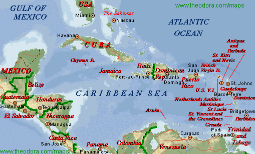
TopicsThe Bahamas
Location:
Caribbean, chain of islands in the North Atlantic Ocean,
southeast of Florida
Select another Topic,
Country,
or go to the Top
Geographic coordinates:24°
15' N, 76° 00' W
|
|
|
|
|
|
|
|
|
|
Area - comparative:
slightly smaller than Connecticut
Coastline:3,542 km
Select another Topic,
Country,
or go to the Top
Maritime claims:
|
|
|
|
|
|
|
|
Climate:
tropical marine; moderated by warm waters of Gulf Stream
Select another Topic,
Country,
or go to the Top
Terrain:
long, flat coral formations with some low rounded hills
Elevation extremes:
lowest point: Atlantic Ocean 0 m
highest point: Mount Alvernia, on Cat Island 63 m
Natural resources:
salt, aragonite, timber
|
|
|
|
|
|
|
|
|
|
|
|
(1993 est.) |
|
Natural hazards:
hurricanes and other tropical storms that cause extensive
flood and wind damage
Environment - current issues:
coral reef decay; solid waste disposal
Environment - international agreements:
party to: Biodiversity, Climate Change, Climate Change-Kyoto
Protocol, Endangered Species, Hazardous Wastes, Law of the Sea, Nuclear
Test Ban, Ozone Layer Protection, Ship Pollution, Wetlands
signed, but not ratified: none of the selected agreements
Geography - note: strategic location
adjacent to US and Cuba; extensive island chain
Select another Topic,
Country,
or go to the Top

Location:
Caribbean, island between the Caribbean Sea and the North
Atlantic Ocean, south of Florida
Select another Topic, Country,
or go to the Top
Geographic coordinates:21°
30' N, 80° 00' W
|
|
|
|
|
|
|
|
|
|
Area - comparative:
slightly smaller than Pennsylvania
|
|
|
|
|
|
(Guantanamo Naval Base is leased by the US and thus remains part of Cuba) |
|
Maritime claims:
|
|
|
|
|
|
Climate:
tropical; moderated by trade winds; dry season (November
to April); rainy season (May to October)
Select another Topic, Country,
or go to the Top
Terrain:
mostly flat to rolling plains, with rugged hills and
mountains in the southeast
Elevation extremes:
lowest point: Caribbean Sea 0 m
highest point: Pico Turquino 2,005 m
Natural resources:
cobalt, nickel, iron ore, copper, manganese, salt, timber,
silica, petroleum, arable land
|
|
|
|
|
|
|
|
|
|
|
|
(1993 est.) |
(1993 est.) |
Natural hazards:
The east coast is subject to hurricanes from August to
October (in general, the country averages about one hurricane every other
year); droughts are common
Environment - current issues:
pollution of Havana Bay; overhunting threatens wildlife
populations; deforestation
Environment - international agreements:
party to: Antarctic Treaty, Biodiversity, Climate Change,
Desertification, Endangered Species, Environmental Modification, Hazardous
Wastes, Law of the Sea, Marine Dumping, Ozone Layer Protection, Ship Pollution
signed, but not ratified: Antarctic-Environmental Protocol,
Climate Change-Kyoto Protocol, Marine Life Conservation
Geography - note: largest country
in Caribbean
Select another Topic, Country,
or go to the Top

Location:
Caribbean, island in the Caribbean Sea, south of Cuba
Select another Topic,
Country,
or go to the Top
Geographic coordinates:18°
15' N, 77° 30' W
|
|
|
|
|
|
|
|
|
|
Area - comparative:
slightly smaller than Connecticut
Land
boundaries:0 km
Select another Topic,
Country,
or go to the Top
Coastline:1,022 km
Maritime claims:
|
|
|
|
|
|
|
|
Climate:
hot, humid; temperate interior
Select another Topic,
Country,
or go to the Top
Terrain:
mostly mountains, with narrow, discontinuous coastal
plain
Elevation extremes:
lowest point: Caribbean Sea 0 m
highest point: Blue Mountain Peak 2,256 m
Natural resources:
bauxite, gypsum, limestone
|
|
|
|
|
|
|
|
|
|
|
|
(1993 est.) |
(1993 est.) |
Natural hazards:
hurricanes (especially July to November)
Environment - current issues:
heavy rates of deforestation; coastal waters polluted
by industrial waste, sewage, and oil spills; damage to coral reefs; air
pollution in Kingston results from vehicle emissions
Environment - international agreements:
party to: Biodiversity, Climate Change, Climate Change-Kyoto
Protocol, Desertification, Endangered Species, Law of the Sea, Marine Dumping,
Marine Life Conservation, Nuclear Test Ban, Ozone Layer Protection, Ship
Pollution, Wetlands, Whaling
signed, but not ratified: none of the selected agreements
Geography - note: strategic location
between Cayman Trench and Jamaica Channel, the main sea lanes for Panama
Canal
Select another Topic,
Country,
or go to the Top

Location:
Caribbean, western one-third of the island of Hispaniola,
between the Caribbean Sea and the North Atlantic Ocean, west of the Dominican
Republic
Select another Topic, Country,
or go to the Top
Geographic coordinates:19°
00' N, 72° 25' W
|
|
|
|
|
|
|
|
|
|
Area - comparative:
slightly smaller than Maryland
|
|
|
|
|
|
|
|
Maritime claims:
|
|
|
|
|
|
|
|
|
|
Climate:
tropical; semiarid where mountains in east cut off trade
winds
Select another Topic, Country,
or go to the Top
Terrain:
mostly rough and mountainous
Elevation extremes:
lowest point: Caribbean Sea 0 m
highest point: Chaine de la Selle 2,680 m
Natural resources:
bauxite, copper, calcium carbonate, gold, marble, hydropower
|
|
|
|
|
|
|
|
|
|
|
|
(1993 est.) |
(1993 est.) |
Natural hazards:
Lies in the middle of the hurricane belt and subject
to severe storms from June to October; occasional flooding and earthquakes;
periodic droughts
Environment - current issues:
Extensive deforestation (much of the remaining forested
land is being cleared for agriculture and used as fuel); soil erosion;
inadequate supplies of potable water
Environment - international agreements:
party to: Biodiversity, Climate Change, Desertification,
Law of the Sea, Marine Dumping, Marine Life Conservation
signed, but not ratified: Hazardous Wastes, Nuclear Test
Ban
Geography - note: shares island
of Hispaniola with Dominican Republic (western one-third is Haiti, eastern
two-thirds is the Dominican Republic)
Select another Topic, Country,
or go to the Top

Location:
Caribbean, eastern two-thirds of the island of Hispaniola,
between the Caribbean Sea and the North Atlantic Ocean, east of Haiti
Select another Topic,
Country,
or go to the Top
Geographic coordinates:19°
00' N, 70° 40' W
|
|
|
|
|
|
|
|
|
|
Area - comparative:
slightly more than twice the size of New Hampshire
|
|
|
|
|
|
|
|
Maritime claims:
|
|
|
|
|
|
|
|
|
|
Climate:
tropical maritime; little seasonal temperature variation;
seasonal variation in rainfall
Select another Topic,
Country,
or go to the Top
Terrain:
rugged highlands and mountains with fertile valleys interspersed
Elevation extremes:
lowest point: Lago Enriquillo -46 m
highest point: Pico Duarte 3,175 m
Natural resources:
nickel, bauxite, gold, silver
|
|
|
|
|
|
|
|
|
|
|
|
(1993 est.) |
(1993 est.) |
Natural hazards:
Lies in the middle of the hurricane belt and subject
to severe storms from June to October; occasional flooding; periodic droughts
Environment - current issues:
Water shortages; soil eroding into the sea damages coral
reefs; deforestation; Hurricane Georges damage
Environment - international agreements:
party to: Biodiversity, Climate Change, Desertification,
Endangered Species, Marine Dumping, Marine Life Conservation, Nuclear Test
Ban, Ozone Layer Protection, Ship Pollution
signed, but not ratified: Law of the Sea
Geography - note: shares island
of Hispaniola with Haiti (eastern two-thirds is the Dominican Republic,
western one-third is Haiti)
Select another Topic,
Country,
or go to the Top

Location:
Caribbean, island between the Caribbean Sea and the North
Atlantic Ocean, east of the Dominican Republic
Select another Topic,
Country,
or go to the Top
Geographic coordinates:18°
15' N, 66° 30' W
|
|
|
|
|
|
|
|
|
|
Area - comparative:
slightly less than three times the size of Rhode Island
Land
boundaries:0 km
Select another Topic,
Country,
or go to the Top
Coastline: 501 km
Maritime claims:
|
|
|
|
|
|
Climate:
tropical marine, mild; little seasonal temperature variation
Select another Topic,
Country,
or go to the Top
Terrain:
mostly mountains, with coastal plain belt in north; mountains
precipitous to sea on west coast; sandy beaches along most coastal areas
Elevation extremes:
lowest point: Caribbean Sea 0 m
highest point: Cerro de Punta 1,338 m
Natural resources:
some copper and nickel; potential for onshore and offshore
oil
|
|
|
|
|
|
|
|
|
|
|
|
(1993 est.) |
(1993 est.) |
Natural hazards:
Periodic droughts; hurricanes
Environment - current issues:
Erosion; occasional drought causing water shortages
Geography - note: important location
along the Mona Passage - a key shipping lane to the Panama Canal; San Juan
is one of the biggest and best natural harbors in the Caribbean; many small
rivers and high central mountains ensure land is well watered; south coast
relatively dry; fertile coastal plain belt in north
Select another Topic,
Country,
or go to the Top

Location:
Caribbean, islands between the Caribbean Sea and the
North Atlantic Ocean, east-southeast of Puerto Rico
Select another Topic,
Country,
or go to the Top
Geographic coordinates:17°
03' N, 61° 48' W
|
|
|
|
|
|
|
(Antigua 281 sq km; Barbuda 161 sq km) |
|
(includes Redonda) |
Area - comparative:
2.5 times the size of Washington, DC
Land
boundaries:0 km
Select another Topic,
Country,
or go to the Top
Coastline: 153 km
Maritime claims:
|
|
|
|
|
|
|
|
|
|
Climate:
tropical marine; little seasonal temperature variation
Select another Topic,
Country,
or go to the Top
Terrain:
mostly low-lying limestone and coral islands, with some
higher volcanic areas
Elevation extremes:
lowest point: Caribbean Sea 0 m
highest point: Boggy Peak 402 m
Natural resources:
NEGL; pleasant climate fosters tourism
|
|
|
|
|
|
|
|
|
|
|
|
(1993 est.) |
|
Natural hazards:
Hurricanes and tropical storms (July to October); periodic
droughts
Environment - current issues:
Water management - a major concern because of limited
natural fresh water resources - is further hampered by the clearing of
trees to increase crop production, causing rainfall to run off quickly
Environment - international agreements:
party to: Biodiversity, Climate Change, Climate Change-Kyoto
Protocol, Desertification, Endangered Species, Environmental Modification,
Hazardous Wastes, Law of the Sea, Marine Dumping, Nuclear Test Ban, Ozone
Layer Protection, Ship Pollution, Whaling
signed, but not ratified: none of the selected agreements
Select another Topic,
Country,
or go to the Top

Location:
Caribbean, island between the Caribbean Sea and the North
Atlantic Ocean, about one-half of the way from Puerto Rico to Trinidad
and Tobago
Select another Topic,
Country,
or go to the Top
Geographic coordinates:15°
25' N, 61° 20' W
|
|
|
|
|
|
|
|
|
|
Area - comparative:
slightly more than four times the size of Washington,
DC
Land
boundaries:0 km
Select another Topic,
Country,
or go to the Top
Coastline: 148 km
Maritime claims:
|
|
|
|
|
|
|
|
Climate:
Tropical; moderated by northeast trade winds; heavy rainfall
Select another Topic,
Country,
or go to the Top

Return to ST Lucia,
ST
Vincent
Terrain: rugged mountains of volcanic origin
Elevation extremes:
lowest point: Caribbean Sea 0 m
highest point: Morne Diablatins 1,447 m
Natural resources:
Timber, hydropower, arable land
|
|
|
|
|
|
|
|
|
|
|
|
(1993 est.) |
|
Natural hazards:
Flash floods are a constant threat; destructive hurricanes
can be expected during the late summer months
Environment - current issues:NA
Environment - international agreements:
Party to: Biodiversity, Climate Change, Desertification,
Endangered Species, Environmental Modification, Hazardous Wastes, Law of
the Sea, Ozone Layer Protection, Whaling
signed, but not ratified: none of the selected agreements
Select another Topic,
Country,
or go to the Top

Location:
Caribbean, island in the Caribbean Sea, north of Trinidad
and Tobago
Select another Topic,
Country,
or go to the Top
|
|
|
|
|
|
|
|
|
|
Area - comparative:
Slightly less than 3.5 times the size of Washington,
DC
Land
boundaries:0 km
Select another Topic,
Country,
or go to the Top
Coastline:158 km
Maritime claims:
|
|
|
|
|
|
|
|
International disputes: none
Climate:
Tropical, moderated by northeast trade winds; dry season
from January to April, rainy season from May to August
Select another Topic,
Country,
or go to the Top
Rainfall and temperature monthly distribution klick here
Terrain:
Volcanic and mountainous with some broad, fertile valleys
Natural resources:
Forests, sandy beaches, minerals (pumice), mineral springs,
geothermal potential
|
|
|
|
|
|
|
|
|
|
|
|
(1993 est.) |
(1993 est.) |
Current issues:
Deforestation; soil erosion, particularly in the northern
region
Natural hazards:
Hurricanes and volcanic activity
International agreements:
Party to - Biodiversity, Climate Change, Endangered Species,
Environmental Modification, Hazardous Wastes, Law of the Sea, Marine Dumping,
Ozone Layer Protection, Whaling
Select another Topic,
Country,
or go to the Top

Island group in Caribbean Sea, part of southern Windward
Islands in Lesser Antilles chain, between latitudes 13 degrees and 14 degrees
north and longitudes 60 degrees and 62 degrees west.
Comprises main island of St. Vincent and islets of the
Northern Grenadines.
Volcanic in origin, mountainous, well-watered and densely
wooded.
Active volcano of the Soufri?re on St. Vincent.
Select another Country,
or go to the Top
Neighboring islands:
north: St. Lucia;
south: Grenada; and,
east: Barbados.
Time:
Greenwich Mean Time less 4 hours.
Climate:
sub-tropical;
January-May dry season, June-December rainy season;
temperature range 18 degrees to 32 degrees Celsius; and,
rainfall varies from 150 centimetres in extreme south
to 381 centimetres in interior of St. Vincent.
Rainfall and temperature monthly distribution klick here
Status:
constitutional monarchy.
Capital:
Kingstown (estimated population 19,345).
Main industries:
agro-processing, light manufacturing.
Main crops:
bananas, sweet potatoes, tropical vegetables, yams, coconut,
nutmegs.
Tourism:
approximately 115,000 visitors per year.
Select another Country,
or go to the Top

Location:
Caribbean, island between the Caribbean Sea and the North
Atlantic Ocean, northeast of Venezuela
Select another Topic,
Country,
or go to the Top
Geographic coordinates:13°
10' N, 59° 32' W
|
|
|
|
|
|
|
|
|
|
Area - comparative:
2.5 times the size of Washington, DC
Land
boundaries:0 km
Select another Topic,
Country,
or go to the Top
Coastline: 97 km
Maritime claims:
|
|
|
|
|
|
Climate:
Tropical; rainy season (June to October)
Select another Topic,
Country,
or go to the Top

Return to Grenada
and Trinidad & Tobago
Terrain:
Relatively flat; rises gently to central highland region
Elevation extremes:
lowest point: Atlantic Ocean 0 m
highest point: Mount Hillaby 336 m
Natural resources:
petroleum, fish, natural gas
|
|
|
|
|
|
|
|
|
|
|
|
(1993 est.) |
|
Natural hazards:
Infrequent hurricanes; periodic landslides
Environment - current issues:
Pollution of coastal waters from waste disposal by ships;
soil erosion; illegal solid waste disposal threatens contamination of aquifers
Environment - international agreements:
Party to: Climate Change, Desertification, Endangered
Species, Hazardous Wastes, Law of the Sea, Marine Dumping, Ozone Layer
Protection, Ship Pollution
signed, but not ratified: Biodiversity
Geography - note: easternmost Caribbean
island
Select another Topic,
Country,
or go to the Top

Location:
Caribbean, island between the Caribbean Sea and Atlantic
Ocean, north of Trinidad and Tobago
Select another Topic,
Country,
or go to the Top
Geographic coordinates:12°
07' N, 61° 40' W
|
|
|
|
|
|
|
|
|
|
Area - comparative:
Twice the size of Washington, DC
Land
boundaries:0 km
Select another Topic,
Country,
or go to the Top
Coastline: 121 km
Maritime claims:
|
|
|
|
|
|
Climate:
Tropical; tempered by northeast trade winds
Select another Topic,
Country,
or go to the Top
Rainfall and temperature monthly distribution klick here
Terrain:
Volcanic in origin with central
mountains
Elevation extremes:
lowest point: Caribbean Sea 0 m
highest point: Mount Saint Catherine 840 m
Natural resources:
Timber, tropical fruit, deepwater harbors
|
|
|
|
|
|
|
|
|
|
|
|
(1993 est.) |
|
Natural hazards:
Lies on edge of hurricane belt; hurricane season lasts
from June to November
Environment - current issues:NA
Environment - international agreements:
Party to: Biodiversity, Climate Change, Desertification,
Endangered Species, Law of the Sea, Ozone Layer Protection, Whaling
signed, but not ratified: none of the selected agreements
Geography - note: the administration
of the islands of the Grenadines group is divided between Saint Vincent
and the Grenadines and Grenada
Select another Topic,
Country,
or go to the Top

Location:
Caribbean, islands between the Caribbean Sea and the
North Atlantic Ocean, northeast of Venezuela
Select another Topic,
Country,
or go to the Top
Geographic coordinates:11°
00' N, 61° 00' W
|
|
|
|
|
|
|
|
|
|
Area - comparative:
slightly smaller than Delaware
Land
boundaries:0 km
Select another Topic,
Country,
or go to the Top
Coastline: 362 km
Maritime claims:
|
|
|
|
|
|
|
|
|
|
Climate:
Tropical; rainy season (June to December)
Select another Topic,
Country,
or go to the Top
Rainfall and temperature monthly distribution klick here
Terrain:
Mostly plains with some hills and low mountains
Elevation extremes:
lowest point: Caribbean Sea 0 m
highest point: El Cerro del Aripo 940 m
Natural resources:
Petroleum, natural gas, asphalt
|
|
|
|
|
|
|
|
|
|
|
|
(1993 est.) |
(1993 est.) |
Natural hazards:
Outside usual path of hurricanes and other tropical storms
Environment - current issues:
Water pollution from agricultural chemicals, industrial
wastes, and raw sewage; oil pollution of beaches; deforestation; soil erosion
Environment - international agreements:
Party to: Biodiversity, Climate Change, Climate Change-Kyoto
Protocol, Endangered Species, Hazardous Wastes, Law of the Sea, Marine
Life Conservation, Nuclear Test Ban, Ozone Layer Protection, Tropical Timber
83, Tropical Timber 94, Wetlands
signed, but not ratified: none of the selected agreements
Select another Topic,
Country,
or go to the Top


