CLIMATOLOGY |
|
CLIMATOLOGY |
Do you want to know about geography,
climate and other characteristics of the countries?
Please, click here for Mexico
and Central America or
The
Caribbean
Otherwise, you can select a country to know more about its meteorological service
México. Servicio
Meteorológico Nacional
Costa Rica. Instituto
Meteorológico Nacional
Belize. Belize
Climate
Panama. Gerencia
de Hidrometeorología y Estudios de ETESA
Ecuador. Instituto
Nacional de Meteorología e Hidrología
Cuba. Instituto
de Meteorología
Bermuda. Bermuda
Weather Resources
Other countries. The
National Weather Services of some Members of the World Meteorological Organization
equipped
with Web Servers
Other sites to know about weather and climate of Mexico, Central America and The Caribbean. Click here
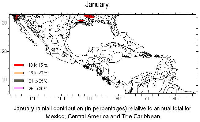
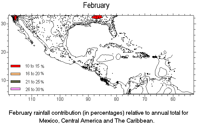
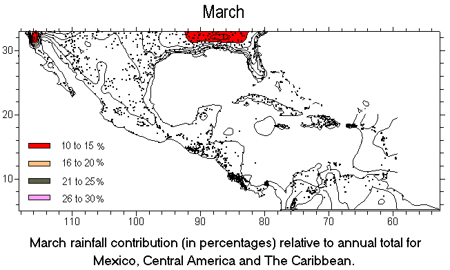
Select a month to see the Composites:
January
- February - March
- April - May
- June - July
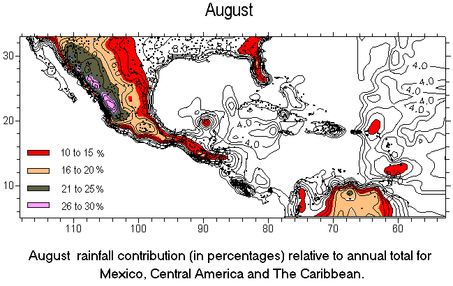
- August -
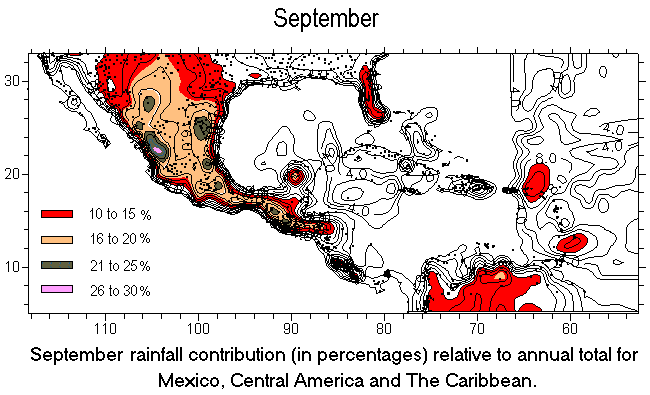
September
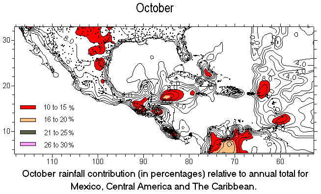
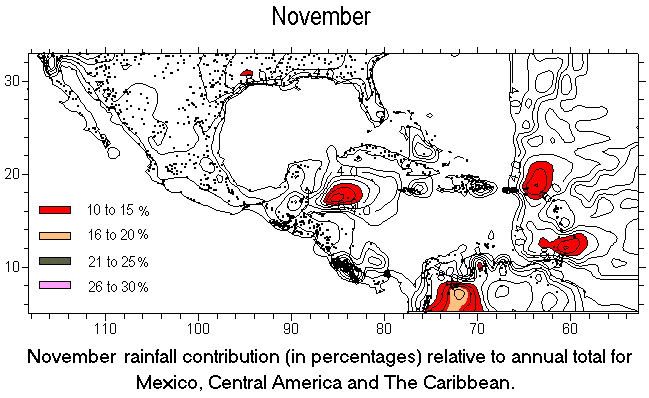
- October - November
- December
or
Click here to
know about the information used to make the Composites
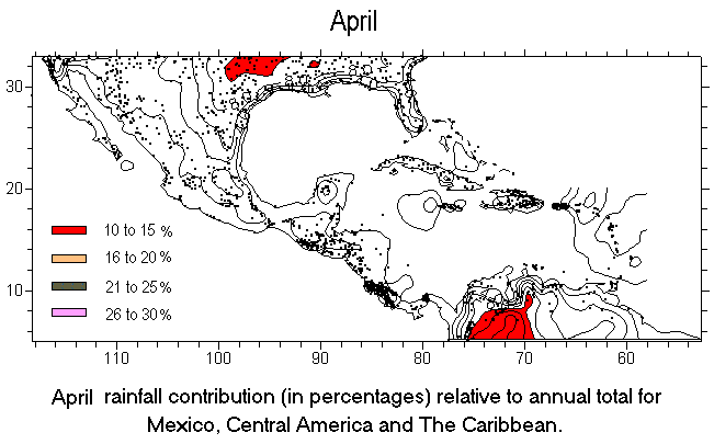
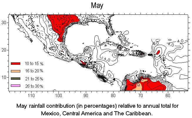
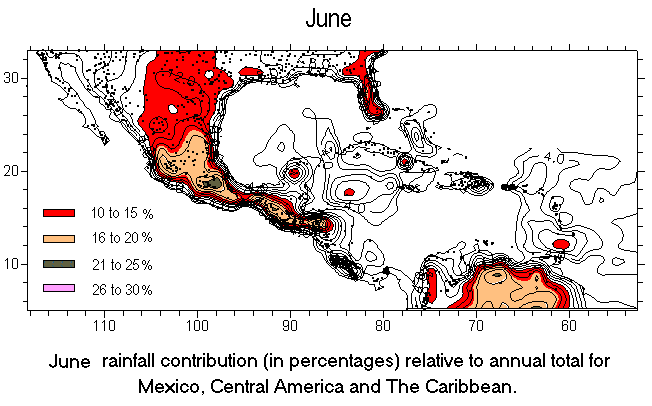
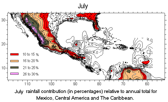
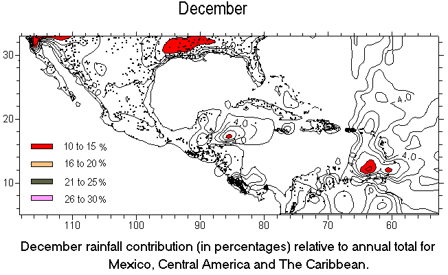
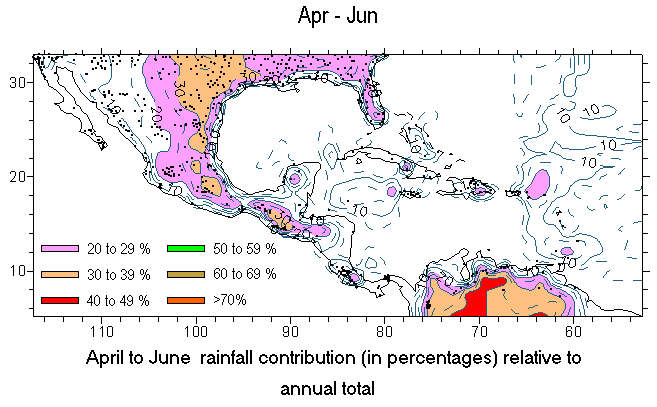
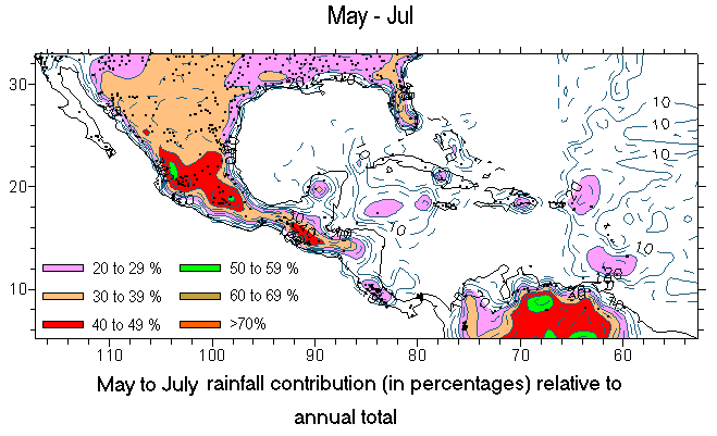
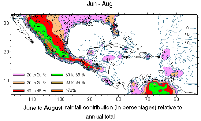
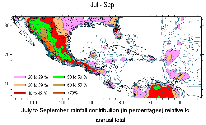
Rainfall
three monthly contribution
in Mexico, Central America,
and The Caribbean.
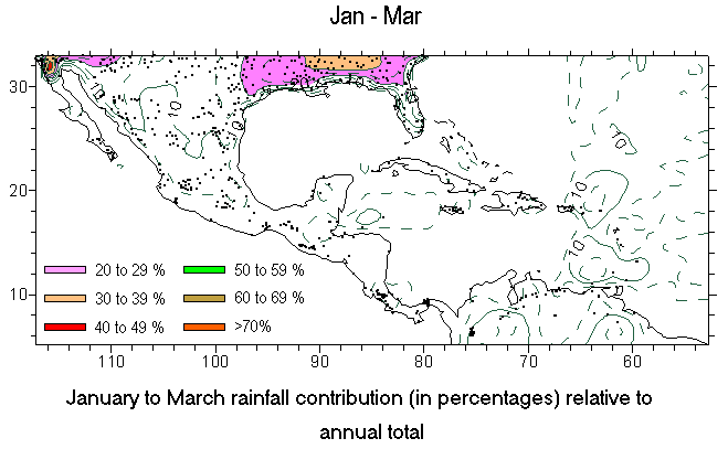
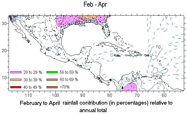
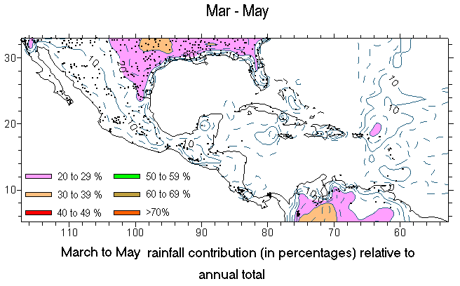
Select a season to see the Composites:
January to March
| February to April | March
to May | April to June | May
to July | June to August |
| July to September
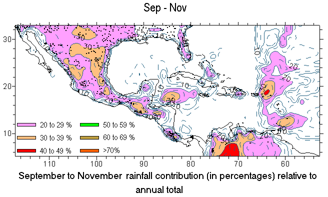
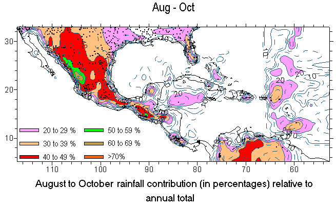
| August to October | September
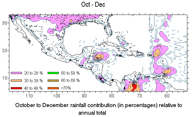
to November | October to December
or
Click here to
know about the information used to make the Composites
Mexico and Central America (see the text)
Select a season to see the Composites:
January to March
- April to June - July
to September - October to December
The Caribbean (see the text)
Select a season to see the Composites:
January to
March - April to June - July
to September - October to December
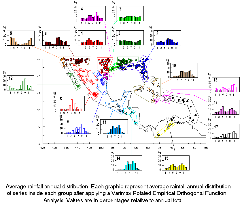
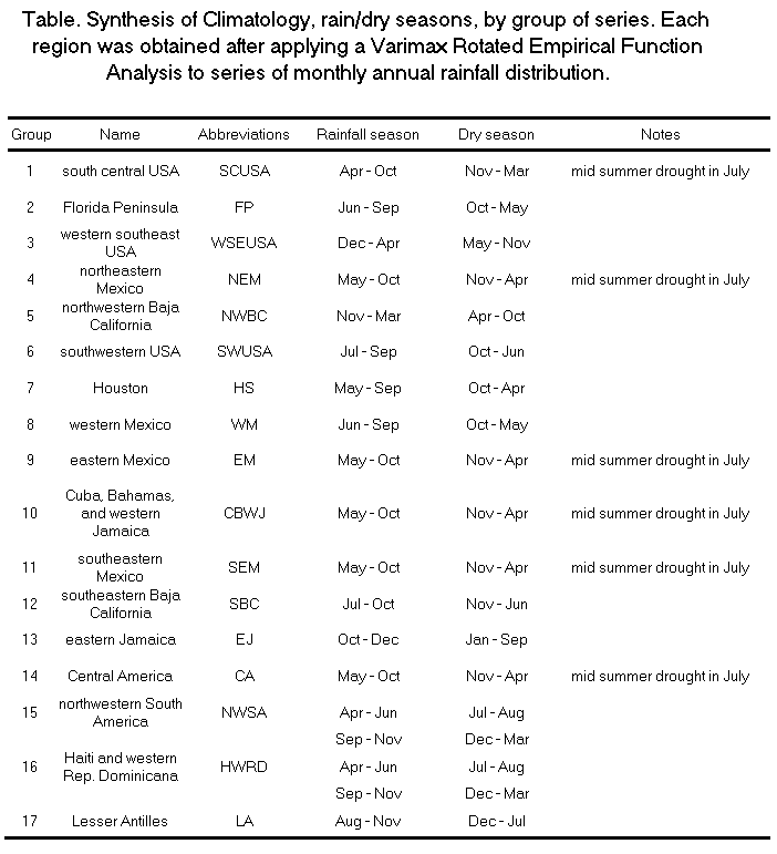
Table. Synthesis of climatology
by groups
Click here to see the Table
select another month
of go to the TOP
select another month
of go to the TOP
select another month
of go to the TOP
select another month
of go to the TOP
select another month
of go to the TOP
select another month
of go to the TOP
select another month
of go to the TOP
select another month
of go to the TOP
select another month
of go to the TOP
select another month
of go to the TOP
select another month
of go to the TOP
select another month
of go to the TOP
Select another Season
or go to the TOP
Select another Season
or go to the TOP
Select another Season
or go to the TOP
Select another Season
or go to the TOP
Select another Season
or go to the TOP
Select another Season
or go to the TOP
Select another Season
or go to the TOP
Select another Season
or go to the TOP
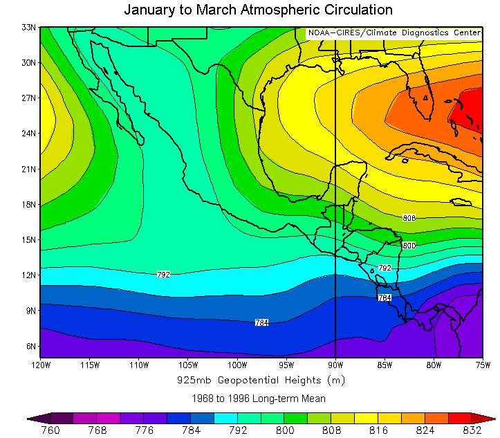
Los mapas de flujo atmosférico
para México y Centro América se calcularon estacionalmente
mediante el programa de la NOAA/CIRES,
promediando las anomalías de alturas geopotenciales a 925 mb(AG925)cada
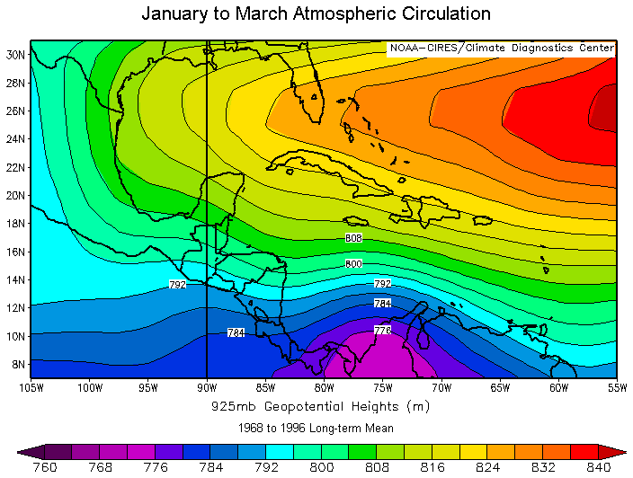
tres meses de 1968 a 1996. El promedio de Enero a Marzo de AG925 muestra
la dominancia de vientos del este sobre Centro América, vientos
del sureste sobre la península de Yucatán y flujo de viento
meridional muy definido sobre la mitad continental oriental de México
(Fig.1).
Select a Composite
of go to the TOP
Este patrón de flujo está
dominado por la celda semipermanente de altas presiones del Atlántico
Norte la cual bloquea la penetración de humedad desde el océano
Atlántico hacia el contiente. Bajo este patrón de flujo,
generalmente, el sureste de México y Centro América reciben
poca humedad desde el Atlántico y Golfo de México. Sobre
la península de California los vientos dominantes del noroeste acarrean
las masas de aire secas y frías del norte que al interactuar con
el viento más cálido y húmedo del Pacífico
subtropical, en ocasiones, producen precipitaciones debido a los frentes
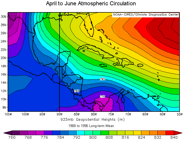
extratropicales. De Abril a Junio, el promedio de AG925 muestra un cambio
en la configuración del patrón de flujo atmosférico
en relación con el anterior (Fig.2).
En este caso los vientos del este sobre
el Pacífico ecuatorial se debilitan formándose una celda
ciclónica posicionada sobre el este de Panamá. Esta celca
ciclónica indica la penetración de humedad desde el Atlántico
hacia Costa Rica y Panamá. Más hacia el norte, los vientos
del sureste dominan el norte de Centro América, la península
de Yucatán, el Golfo de México y Cuba con poca afluencia
de humedad del Caribe. Sobre el norte de México se posiciona una
celda ciclónica la cual indica una intensificación del gradiente
barométrico con penetración de humedad desde el Pacífico
y Golfo de California. El Patrón de flujo atmosférico promedio
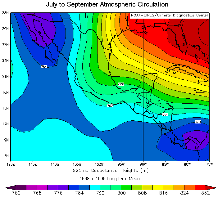
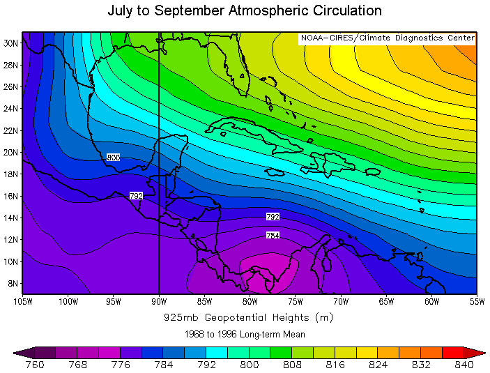
de Julio a Septiembre (Fig.3) sigue mostrando la
celda ciclónica al este de Panamá y vientos del este que
cruzan Centro América con dirección hacia el Pacífico
tropical.
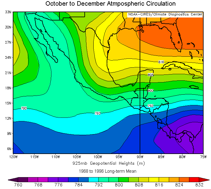
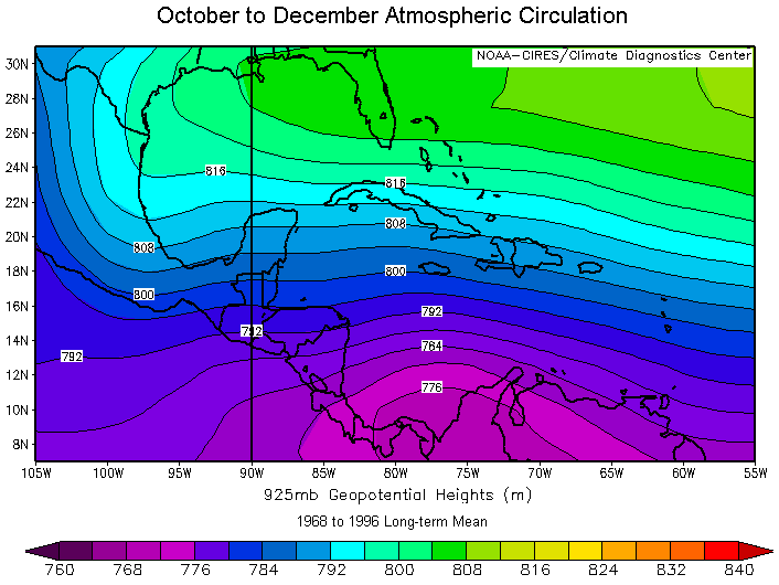
Bajo estas condiciones la humedad proveniente del Caribe y Golfo de México penetra hacia el continente. Hacia el norte de México se forma un flujo proveniente del Pacífico tropical favorecido por la celda ciclónica posicionada sobre la península de California. De Octubre a Diciembre, el patrón de flujo atmosférico muestra nuevamente un flujo del este que atravieza Centro América con dirección hacia el interior del Pacífico tropical al suroeste de México (Fig.4).
Sobre el Golfo de California se forma un corredor de vientos opuestos dominados por un flujo meridional del sureste, sobre la porción continental de México y un flujo del noroeste sobre la costa occidental de la Península de California.
Los patrones de flujo promedio de alturas
geopotenciales a 925 mb para la región de las islas Bahamas, Cuba
y el Caribe, muestra la dominancia de los alisios con flujo del sureste
en la mayoría de las estaciones (Figs. 5,
6
y 7).
Select a Composite
of go to the TOP
El promedio de AG925 de Enero a Maro
y de Abril a Junio muestra una celda ciclónica posicionada al este
de Panamá, indicación de penetración de humedad desde
el ecuador hacia el norte de Sudamérica y Panamá. Esta celda
ciclónica aparece desplazada hacia el noroeste en la estación
de verano del hemisferio norte (Fig.7) lo que indica
un desplazamiento de la Zona de Convergencia Intertropical favoreciendo
la penetración de humedad en el mismo sentido. De Octubre a Diciembre
la celda ciclónica se encuentra posicionada más hacia el
sureste, sobre el este de Panamá y oeste de Colombia, mientras que
en el Caribe, Cuba y las islas de las Bahamas el flujo del este es dominante
en toda esta zona (Fig.8).
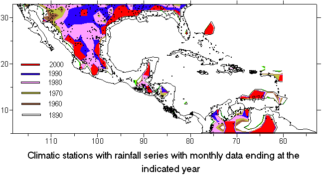
Rainfall
monthly data used to make the Composites
Rainfall monthly data was obtained
from the IRI Data Library.
Here we show some characteristics related to this information.
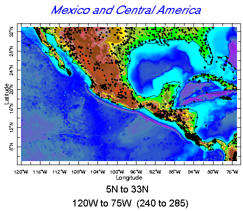
Climatic stations located in Mexico and Central America:
Select another Topic or go to the TOP
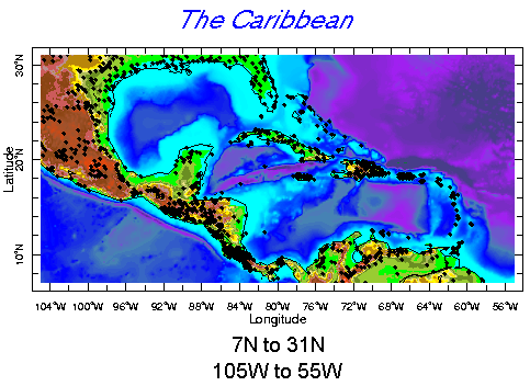
Climatic stations located in The Caribbean:
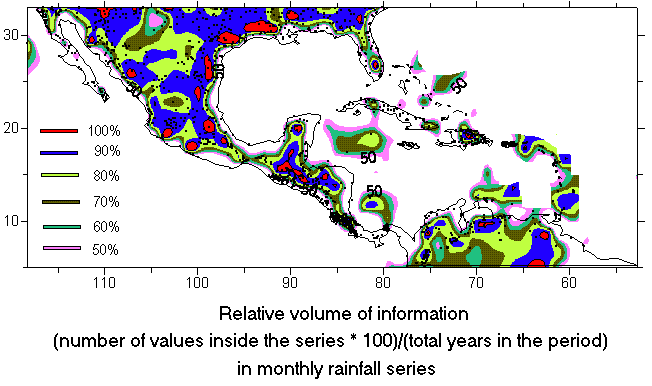
Relative volume of information:
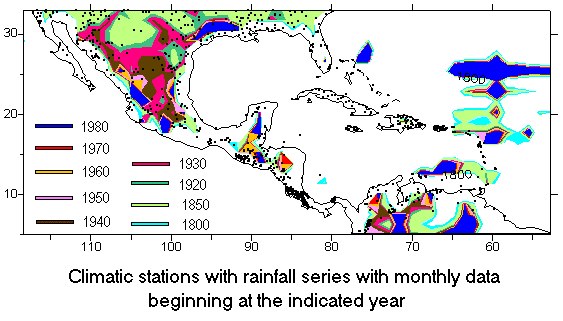
Year when rainfall series begin
Year when rainfall series end