ENSO |
|
ENSO |
ENSO
Composites
Rank (%) values during warm, base, and cold episodes
by groups
Select a group to see the Composite
|Group 1| Group 2| Group
3| Group 4| Group 5| Group
6| Group 7| Group 8| Group
9|
|Group 10| Group 11| Group
12| Group 13| Group 14| Group
15| Group 16| Group 17|
El Niño minus La Niña) years
Select a season:
| January to February
|
April
to June | July to August | October
to December |
ENSO Reports
Click
here to see the reports for Mexico, Central America, and The Caribbean
Do you want to know more about ENSO?. Here, you can find more information
ENSO information from NOAA - CIRES Climate Diagnostics Center
NOAA -
OGP El Niño Southern Oscillation Page
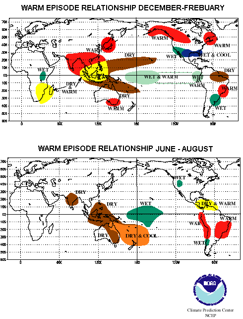
Figure 1. Warm episode relationship for December to February and June to August
ENSO composites, rank values
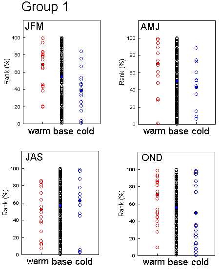
Group 1
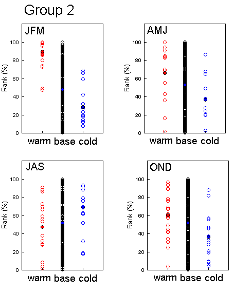
Group 2
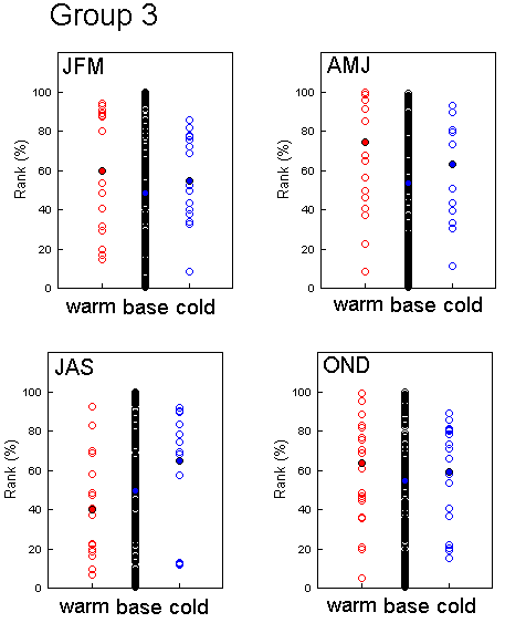
Group 3
Group 4
Group 5
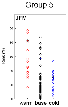
Precipitation distributions for (from left to right) warm episodes,
the base period, and cold episodes for January to March season of group
of series in Northwestern Baja California (Group
5). The bold circles represent the average values of each episode.
The percentile ranks are for the entire period of observations. For each
season, the entire n-year record of precipitation data was ranked from
"1", for the smallest precipitation amount, to "n" for the largest precipitation
amount. These ranked precipitation amounts were then normalized by the
numbers of years of record and multiplied by 100. The years for either
warm of cold episode for each season are the same as those reported by
the Climate
Prediction Center
Group 6
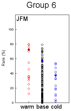
Precipitation distributions for (from left to right) warm episodes,
the base period, and cold episodes for January to March season of group
of series in Southwestern USA (Group
6). The bold circles represent the average values of each episode.
The percentile ranks are for the entire period of observations. For each
season, the entire n-year record of precipitation data was ranked from
"1", for the smallest precipitation amount, to "n" for the largest precipitation
amount. These ranked precipitation amounts were then normalized by the
numbers of years of record and multiplied by 100. The years for either
warm of cold episode for each season are the same as those reported by
the Climate
Prediction Center
Group 7
Group 8
Precipitation distributions for (from left to right) warm episodes,
the base period, and cold episodes for January to March season of group
of series in Western Mexico (Group
8). The bold circles represent the average values of each episode.
The percentile ranks are for the entire period of observations. For each
season, the entire n-year record of precipitation data was ranked from
"1", for the smallest precipitation amount, to "n" for the largest precipitation
amount. These ranked precipitation amounts were then normalized by the
numbers of years of record and multiplied by 100. The years for either
warm of cold episode for each season are the same as those reported by
the Climate
Prediction Center
Group 9
Group 10
Group 11
Precipitation distributions for (from left to right) warm episodes,
the base period, and cold episodes for January to March season of group
of series in Southeastern Mexico (Group
11). The bold circles represent the average values of each episode.
The percentile ranks are for the entire period of observations. For each
season, the entire n-year record of precipitation data was ranked from
"1", for the smallest precipitation amount, to "n" for the largest precipitation
amount. These ranked precipitation amounts were then normalized by the
numbers of years of record and multiplied by 100. The years for either
warm of cold episode for each season are the same as those reported by
the Climate
Prediction Center
Group 12
Precipitation distributions for (from left to right) warm episodes,
the base period, and cold episodes for January to March season of group
of series in Southern Baja California (Group
12). The bold circles represent the average values of each episode.
The percentile ranks are for the entire period of observations. For each
season, the entire n-year record of precipitation data was ranked from
"1", for the smallest precipitation amount, to "n" for the largest precipitation
amount. These ranked precipitation amounts were then normalized by the
numbers of years of record and multiplied by 100. The years for either
warm of cold episode for each season are the same as those reported by
the Climate
Prediction Center
Group 13
Precipitation distributions for (from left to right) warm episodes,
the base period, and cold episodes for January to March season of group
of series in Eastern Jamaica (Group
13). The bold circles represent the average values of each episode.
The percentile ranks are for the entire period of observations. For each
season, the entire n-year record of precipitation data was ranked from
"1", for the smallest precipitation amount, to "n" for the largest precipitation
amount. These ranked precipitation amounts were then normalized by the
numbers of years of record and multiplied by 100. The years for either
warm of cold episode for each season are the same as those reported by
the Climate
Prediction Center
Group 14
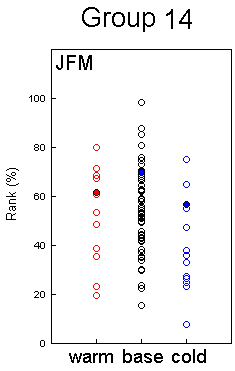
Precipitation distributions for (from left to right) warm episodes,
the base period, and cold episodes for January to March season of group
of series in Central America (Group
14). The bold circles represent the average values of each episode.
The percentile ranks are for the entire period of observations. For each
season, the entire n-year record of precipitation data was ranked from
"1", for the smallest precipitation amount, to "n" for the largest precipitation
amount. These ranked precipitation amounts were then normalized by the
numbers of years of record and multiplied by 100. The years for either
warm of cold episode for each season are the same as those reported by
the Climate
Prediction Center
Group 15
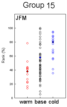
Precipitation distributions for (from left to right) warm episodes,
the base period, and cold episodes for January to March season of group
of series in Northwestern South America (Group
15). The bold circles represent the average values of each episode.
The percentile ranks are for the entire period of observations. For each
season, the entire n-year record of precipitation data was ranked from
"1", for the smallest precipitation amount, to "n" for the largest precipitation
amount. These ranked precipitation amounts were then normalized by the
numbers of years of record and multiplied by 100. The years for either
warm of cold episode for each season are the same as those reported by
the Climate
Prediction Center
Group 16
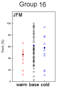
Precipitation distributions for (from left to right) warm episodes,
the base period, and cold episodes for January to March season of group
of series in Haiti and western Dominican Republic (Group
16). The bold circles represent the average values of each episode.
The percentile ranks are for the entire period of observations. For each
season, the entire n-year record of precipitation data was ranked from
"1", for the smallest precipitation amount, to "n" for the largest precipitation
amount. These ranked precipitation amounts were then normalized by the
numbers of years of record and multiplied by 100. The years for either
warm of cold episode for each season are the same as those reported by
the Climate
Prediction Center
Group 17
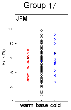
Precipitation distributions for (from left to right) warm episodes,
the base period, and cold episodes for January to March season of group
of series in Lesser Antilles (Group
17). The bold circles represent the average values of each episode.
The percentile ranks are for the entire period of observations. For each
season, the entire n-year record of precipitation data was ranked from
"1", for the smallest precipitation amount, to "n" for the largest precipitation
amount. These ranked precipitation amounts were then normalized by the
numbers of years of record and multiplied by 100. The years for either
warm of cold episode for each season are the same as those reported by
the Climate
Prediction Center
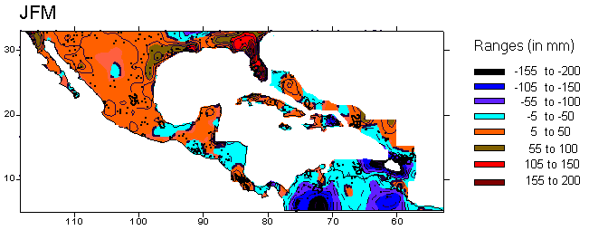
Anomaly differences (in mm)
in 1950 to 2001 period between El Niño minus La Niña years
in January to March season. El Niño and La Niña episodes
by seasons are the same as those proposed by the Climate
Prediction Center.
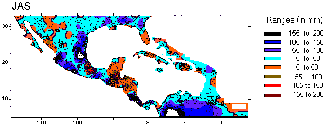
Anomaly differences (in mm)
in 1950 to 2001 period between El Niño minus La Niña years
in July to September season. El Niño and La Niña episodes
by seasons are the same as those proposed by the Climate
Prediction Center. Go to the Top
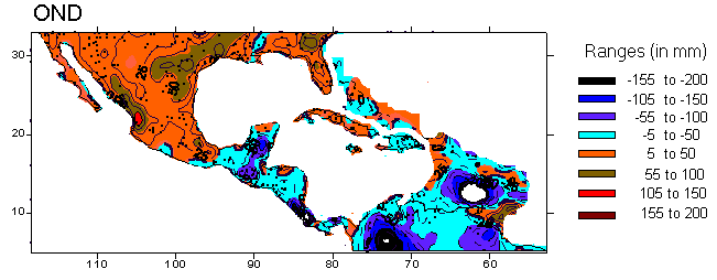
Anomaly differences (in mm)
in 1950 to 2001 period between El Niño minus La Niña years
in October to December season. El Niño and La Niña episodes
by seasons are the same as those proposed by the Climate
Prediction Center.
Go to the Top
El
Niño
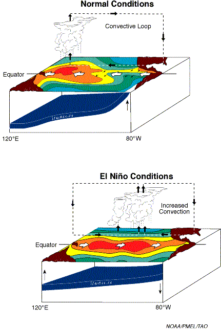
What is El Niño - Southern Oscillation
(ENSO)?
El Niño is an excellent example of the interaction between the
ocean and the atmosphere and there combined effect on climate.
El Niño is a disruption of the ocean-atmosphere system in the
tropical Pacific having important consequences for weather around the globe.
This condition results in redistribution of rains with flooding and droughts.
Along the equator, the western Pacific has some of the world's warmest ocean water, while in the eastern Pacific, cool water wells up, carrying nutrients that support large fish populations.
Every two to seven years, strong westward-blowing trade winds subside, and warm water slowly moves back eastward across the Pacific, like water shifting in a giant bathtub.
The warm water and shifting winds interrupt the upwelling of cool, nutrient-rich
water. Fish die; climatic changes affect many parts of the world.
Peruvians named this phenomenon El Niño, for the Christ child,
because it first appears around Christmas.
El Niño is Spanish for the Chirst Child. Historically, the term was used by the fisherman along the coast Ecuador and Peru to refer to a warm, nutrient-poor, ocean current that typically appears around Christmas-time and last several months. El Nino is accompanied by heavy rains, often resulting in catastrophic flooding. The local economy suffers from the loss of fish and guano birds.
El Niño - Southern Oscillation (ENSO) phenomenom is a global event arising from large-scale interaction between the ocean and the atmoshere. The Southern Oscillation, a more recent discovery, refers to an oscillation in the surface pressure (atmospheric mass) between the southeastern tropical Pacific and the Australian-Indonesian regions. When the waters of the eastern Pacific are abnormally warm (an El Niño event) sea level pressure drops in the eastern Pacific and rises in the west. The reduction in the pressure gradient is accompanied by a weakening of the low-latitude easterly trades.
Since the late 1950's there have been seven major El Niño events:
1957-58, 1965, 1968-69, 1972-73, 1976-77, 1982-83, 1986-87, 1991-92 and 1994-95.
The 1982-83 El Niño was the strongest of this century.
The possible interrelationship between El Niño and global weather
patterns, especially the simultaneous droughts in the Sovet Union, Africa,
Australia, and Central America, was first realized in 1972-73. Relationships
between El Nino and other global weather anomalies are known as teleconnections.
Go to the Top
1. FISH/MARINE MAMMALS AND REPTILES
13 NOVEMBER
1997. NICARAGUA, COSTA RICA & MEXICO: SEA TURTLES
(http://darwin.bio.uci.edu/~sustain/Enso97/1197/13NovCosta.html)
Select another month
or go to the TOP
CNN (with Associated Press and Reuters contributions)
reported that high tides and drought associated with El Nino are threatening
nests of olive ridley turtles at La Flor, Nicaragua. Only 20,000 turtles
have hatched his year, down from 185,000 last year during a comparable
period. La Flor produces about half of the country's turtle production
each year. Similar damage has been reported from Costa Rican nesting beaches.
In Mexico, Hurricane Pauline destroyed only about 20 % of the nests.
24 NOVEMBER 1997. MEXICO: AQUACULTURE
(http://darwin.bio.uci.edu/~sustain/Enso97/1197/24NovMex.html)
"This is just a short note about the effects of the recent El Nino in
our pearl culture operations at Bahia de La Paz, South Baja California.
1. We registered nearly 4 C over the normal maximum temperature we usually
read in the Bay, but this was only registered between surface and 4 m depth.
This acted to our advantage because we moved the whole installation to
deeper waters. The cumulative average mortality was very similar as the
normal average we register during the same season and within the same size/age
of pearl oysters, this is, very low (2.5 to 3.5 >%).2. On the contrary,
we observed an extremely high natural recruitment. Our spat collectors
(even the fact that we were not using "the good ones") had averages of
150 spat per unit, when into those kind of collectors we usually had not
more than 10 per unit.3. Among the other species associated to collectors
of Pinctada mazatlanica (spatfall of this pearl oyster in Bahia de La Paz
is in summer), we observed a completely different composition of the one
we consider as "standard". Many species were absent and many other were
"new". Vertical distribution was also all messed up both on the associated
species and in P. mazatlanica. The maximal spatfall of P. mazatlanica takes
place between 2 and 6 m depth and it is very rare from 8 m down. This time
we got the maximal spatfall between 5 and 12 m depth.4. Every object on
the bottom (old tires, ropes, the galvanized pipe structures we use for
bottom culture, etc.) was covered with spat of P. mazatlanica. We believe
that this event was a very important factor for therecovery of pearl oyster
wild beds. We will follow some of these wild juveniles to see how they
behave. Maybe in a couple of years the low density ofnatural beds will
change positively."--Mario Monteforte <montefor@cibnor.mx>, forwarded
by Barry A. Costa-Pierce <bcp@uci.edu>
5 DECEMBER.
MEXICO: AQUACULTURE
(http://darwin.bio.uci.edu/~sustain/Enso97/1297/05DecMex.html)
Baja California: "We are still registering up to 5ºC of difference
in comparison with normal years. It seems this phenomenon is being favorable
for summer-spawners species such as Pinctada mazatlanica of which we are
still observing spatfall (it should have finished a while ago !!). On the
contrary, we should expect the presence of good gonad maturity in Pteria
sterna (this one is a winter-spawner at Bahia de La Paz), but there is
not any mature specimen. Usually in late November and early December the
presence of stages 3 or 4 in gonad development (this is almost ripe) is
common on this species. We could predict a quite poor spatfall of Pteria
sterna this winter, and I could even adventure to say that, if this weather
stays longer, there could be no spatfall at all. Besides, a strict monitoring
of water temperature and also of other indexes we have defined for previewing
the spatfall of Pinctada mazatlanica, will have to be undertaken from February-March
on next year. Probably the main recruitment of P. mazatlanica will be very
much in advance next year."--Mario Monteforte <montefor@cibnor.mx> VIA
Barry A. Costa-Pierce<bcp@uci.edu>.
Select another month
or go to the TOP
12 DECEMBER 1997. MEXICO, BAJA CALIFORNIA:
MARINE MAMMALS
(http://darwin.bio.uci.edu/~sustain/Enso97/1297/12DecMex.html)
Just back from Baja - sea kayaking in the Sea of Cortez. Great trip!
Snorkeled with a Giant Manta, LOTS of sea lion pups and their mothers.
Hard for me to think El Nino is having a negative effect.
The last big El Nino, in '83, the whales arrived, stayed & departed
as they always have done. Think of it this way, they have had millions
of years of migration and many El Nino's during that time. We do anticipate
a wet season but that doesn't bother the whales! The whales are not feeding
on their journey south to the lagoons. They live off stored fat during
their migration and are mating and giving birth while in the lagoons. But,
remember, Nature has no guarantees."--Jeanne, Baja Expeditions <travel@adnc.com>.
30 DECEMBER. MEXICO: MARINE (FISHERIES &
SEABIRDS)
(http://darwin.bio.uci.edu/~sustain/Enso97/1297/30DecMex.htm)
Jalisco, Mexico, La Manzanilla, Tinicatata Bay, North of Barra de Navidad,
19o17' N 104o44' W, Air temperature: 80oF, Water temperature: 80oF. According
to a local fishing guide, the waters are warmer than normal, and the fish
have yet to show up. Normally he would catch dorado, sailfish, and yellowfin(?)
tuna but they were few and far in between. Flying fish should have been
seen. We saw none. Brown Pelicans were abundant, but we saw only a half
dozen boobies (there should have been many), and never saw one diving for
food. We saw one sailfish hit a surface longline about 4 mile offshore.
While seakayaking, I saw two phalaropes (Wilson's?) dead in the water.We
also observed a couple dead bird blobs on a half mile stretch of beach.--Jim
Reed < jpreed@efn.org>
Select another month
or go to the TOP
APRIL 1998.
MEXICO (BAJA CALIFORNIA): SEABIRDS AND ABALONES
(http://darwin.bio.uci.edu/~sustain/Enso97/0498/AprMex.htm)
Isla Natividad (28 N, 115 W): "I observed sooty and/or short tailed shearwaters in the Canal de Dewey off isla Natividad, Baja California Sur Mexico almost daily from April 14 to April 28. In 1997 these birds were common in large flocks, but the first birds were not seen until June 21 of that year. In addition, the numbers of black-vented shearwaters breeding on isla Natividad are significantly reduced. In 1997 60% of the burrows on the island contained breeding birds and all eggs were laid before April 5. This year only 20% of the burrows have breeding birds and birds were still laying in late April. The fishermen on the island say this is the worst year for harvesting abalone since 1981/82. The abalone are very thin and there is little algae on the rocks for them to graze. Much of the Macrocystis around the island was killed during the October hurricane, and it has not regrown this year."--Bradford Keitt <bkeitt@cats.ucsc.edu>
17 APRIL. MEXICO: FISHERY
(http://darwin.bio.uci.edu/~sustain/Enso97/0498/17AprMex.htm)
Xinhua reports that El Nino conditions off Mexico's west coast has improved
fishing 20% or $70 million (U.S.).
Select another month
or go to the TOP
2. BIRDS
5 OCTOBER
1997. MEXICO:
(http://darwin.bio.uci.edu/~sustain/Enso97/1097/05OctMex.html)
SEABIRDS, MARINE MAMMALS, HURRICANES Just finished a six-week research cruise onboard the NOAA R/V "David Starr Jordan" operating in the very shallow waters (mostly less than 100 meters) of the upper Gulf of California (Sea of Cortez) and Colorado River delta and mouth (mid-Aug to late-Sep). Having never worked in this part of the Gulf before, I have no comparative experience as to how the region may have been influenced by the current ENSO event and analyses of oceanographic data are incomplete. I suspect nothing much really. If anything, it was much more windy than was expected and as suggested by the local fishermen. We were expecting mostly calm Beaufort 0-2 sea states. Up until about mid-September, the almost relentless winds were humid tropical southeasterlies, 15-25knots, with resulting sea states at B-4 to B-6. This hampered study efforts but had a cooling effect on the air temperature keeping it down to a relatively tolerable low-mid 90's F (31 - 33C) while sea surface temperatures hovered around 90 F (31 C). On land (adjacent desert areas, NE Baja & NW Sonora, Mexico) daily daytime temperatures maintained reasonably normal desert levels 105 - 115F (40 - 46C) but with heat "comfort" indices reaching extremes as high as a blood boiling 160 F (71 C) -- this figure via local TV received aboard ship from Yuma, Arizona. Typical overnight low temperatures were often in the humid low to mid-80's (26 - 30C) which were warmer than normal. Our cumulative incidental seabird sightings seemed to indicate nothing really out of the ordinary relative to El Niño. The upper Gulf of California seems like an odd place to find the SOUTH POLAR SKUA (typically 3-8 per day -- possibly same birds I suppose), but this species is apparently a regular part of the summer avifauna here with concentrations as high as 35 birds counted in a single sweep during a 1993 visit to this area, then associated with fishing activity (pers.com. Bob Pitman & Mike Force). [WHY has this species not yet turned up at California's Salton Sea??? ...or has it? "Nora"?? If the South Polar Skua can cross the vast icy desert of Antarctica to reach the South Pole at Admundson-Scott Base (the only species of bird ever recorded there), then a little bit of scalding hot sandy desert shouldn't be such an impossible barrier].
A few to several dozen Sooty and Pink-footed Shearwaters were present
daily throughout the period with Sooties all the way up into the delta
and along Sonoran desert beaches. The Sooty Shearwaters certainly appeared
to be way out of their element in these "hot" waters, appearing severely
bedraggled in ragged states of molt, sickly, and oily "slick" as the plumage
appeared wet and soaked and not shedding sea water properly. The Pink-footed's
appeared to be in much better shape than the Sooties and seemed much more
at home in somewhat deeper offshore waters (>40 m) as were the majority
of Black-vented Shearwaters.
Otherwise, the characteristic residents of the region [Black-vented
Shearwater, Black and Least Storm Petrel, Red-billed Tropicbird, Brown
and Blue-footed Booby, Brown Pelican, Magnificent Frigatebird, Heermann's
and Yellow-footed Gull, and Elegant, and Common Terns] were plentiful,
seen daily, and appeared to be doing well. There were no Craveri's Murrelet
sightings and none were expected. The only Laughing Gull was an immature
on 9/23. A panga trip in the channels around Pelican and Montague Islands
inside the mouth of the Rio Colorado on 9/21 noted 200-300 Black Skimmers,
a few Gull-billed Terns, American Oystercatcher, Wilson's Plovers, and
numerous large waders, especially Long-billed Curlews and Marbled Godwits,
et.al., and sneaky "small-sized" Bottle-nosed Dolphins (_Tursiops sp._)
that could easily be mistaken for Vaquita (a very rare and endangered porpoise
Phocoena sinus) by their slow snap rolling "porpoise-like" behavior in
those incredibly turbid waters, but definitely no Vaquita there.
Rarities to the upper Gulf, though probably not to be unexpected included Buller's Shearwater (1), Masked Booby (3) [both yellow and orange-billed forms], Red-footed Booby (1), dark-rumped Leach's (2-3), and Galapagos Storm Petrel (1). A single Wilson's Storm Petrel pattering, planing, and skipping along the surface amongst several thousand Black and Least Storm Petrels in the wake of a fishing boat north of the Midriff Islands, and Audubon's Shearwater off Guaymas were most notable, and both seen during a refueling transit run on 9/01.
Numerous and immense spectacular flocks of migrating Black Terns (tens of thousands!!) and Least Terns (many hundreds to low thousands) were present in waters off Guaymas on 9/01. During the return transit from Guaymas to San Felipe, the "Mother of tern flocks" a massive dense feeding frenzy of 25-50,000 Black Terns were seen off Isla San Sebastian at sunset on 9/04 stretching for more than a mile and looked like a black cloud of insects in the distance!! Sabine's Gull, and all three jaeger species [Parasitic, Pomarine, and Long-tailed (rare)] were regular in small numbers in the upper Gulf through the period. Most of these birds were immature and may have arrived from overland.
There were three Pacific Hurricanes affecting Baja during the study. 40-50 knot pressure gradient SSE winds between "Ignacio" off western Baja and High Pressure over Texas pushed several hundred Sooty Shearwaters and 2-3 dark-rumped Leach's Storm Petrels into Colorado River delta area on 8/16. Superstorm (Category 5) "Linda" turned west off Cabo San Lucas, a relief to everyone and had no effect on the upper Gulf.
"Nora" (Category 1) cut across central Baja from the Pacific side and scored a direct hit on San Felipe and delta area on 9/24-25 (2300 - 0800hrs). At the storms height, driving east winds were sustained at 60-80 knots for about three hours (0500 - 0800hrs) and 13.2 inches (~335 mm) of rain fell. At 0800 hrs, the whole thing abruptly stopped dead, the sun came out and the storm was over. We thought it was the eye, but in fact the storm was indeed over not realizing that this storm had a clockwise rotation. Substantial damage was done to the boat harbor and protective breakwater with about 30 pangas busted up and sunk (including our's), some structural damage and flooding in town, and wide-spread desert flash flooding caused extensive road damage. Mike Force and I had just disembarked in San Felipe as "Nora" approached and we ended up stranded there for four days until rescue arrived to take us and scientific gear to San Diego.None-the-less, it was an "interesting" adventure watching the ongoing fury at beach-side from the Las Misiones Resort Hotel where we had a commanding view of the whole show while hoping that it wouldn't get worse and trying to stay out of the line of fire from flying debris, glass, and breaking windows.
There were no seabirds of note in the immediate wake of the storm at San Felipe other than the offshore regulars having been blown near shore. However, storm fallout reported by birders in desert birding locales of SE California and Arizona included a scattering of many of the characteristic species of the upper Gulf. At least some of these included, Black and Least Storm Petrels, Black-vented Shearwater, Red-billed Tropicbird, Brown and Blue-footed Boobies, and Magnificent Frigatebird.
A sub-adult "yellow-billed" Masked Booby observed on 9/23, just ahead
of "Nora" by Mike Force and me in the Upper Gulf east of "Rocas Consag"
may be particularly notable and may have either been a belated lost gift
of "Linda", or was pushed well ahead of "Nora" which had stalled south
of Cabo for a few days, or perhaps was assisted by both.--Richard Rowlett
Pagodroma@aol.com
Select another month
or go to the TOP
30 DECEMBER.
MEXICO: MARINE (FISHERIES & SEABIRDS)
(http://darwin.bio.uci.edu/~sustain/Enso97/1297/30DecMex.htm)
Jalisco, Mexico, La Manzanilla, Tinicatata Bay, North of Barra de Navidad,
19o17' N 104o44' W, Air temperature: 80oF, Water temperature: 80oF. According
to a local fishing guide, the waters are warmer than normal, and the fish
have yet to show up. Normally he would catch dorado, sailfish, and yellowfin(?)
tuna but they were few and far in between. Flying fish should have been
seen. We saw none. Brown Pelicans were abundant, but we saw only a half
dozen boobies (there should have been many), and never saw one diving for
food.
We saw one sailfish hit a surface longline about 4 mile offshore. While
seakayaking, I saw two phalaropes (Wilson's?) dead in the water.We also
observed a couple dead bird blobs on a half mile stretch of beach.--Jim
Reed < jpreed@efn.org>
Select another month
or go to the TOP
14 -17
MARCH 1998. MEXICO: SEABIRD (MORTALITY)
(http://darwin.bio.uci.edu/~sustain/Enso97/0398/14MarMex.htm)
Bahia Kino, Sonora: "While bird-watching along coast I found fresh carcasses (death within 48 hours based on lack of predation and lack of maggots) as follows (in a 2 km stretch): 3 eared or horned grebes (id ?), 1 western grebe, 6 Brown pelicans, 3 loons (common or Pacific?), 1 Blue-footed booby, 1 dolphin/small pilot whale (i.d.?), 1 small sea lion (species ?), Some of mortality may be due to by-catch in fishing nets as local fishers said they do catch birds, but they said that they are seeing more dead birds floating around, and that they are catching less fish this year."--Dusty Becker cbecker@indiana.edu AND "This sounds similar to the numbers of dead seabirds Kathy Molina and I have been finding at El Golfo de Santa Clara at the northern end of the Sonora, Mexico, coast (though we haven't walked as much of the beach). Most carcasses there in February 1998 were Pacific Loons, Common Loons, and Western Grebes, but we've also found (over the past 2-3 years) Clark's and Eared grebes, Blue-footed and Brown boobies, Brown Pelicans, Surf Scoters, Red-breasted Mergansers and even an American Coot. I agree that fishing nets seem to be a likely explanation, and we have the impression that the numbers of beached birds this past winter haven't been significantly higher than previous years (i.e. no obvious "El Nino" peak in mortality). Dan Anderson (dwanderson@ucdavis.edu) would be very interested in any band numbers you might have obtained from dead Brown Pelicans."-- Kimball L. Garrett <kgarrett@nhm.org
APRIL
1998. MEXICO (BAJA CALIFORNIA): SEABIRDS AND ABALONES
(http://darwin.bio.uci.edu/~sustain/Enso97/0498/AprMex.htm)
Isla Natividad (28 N, 115 W): "I observed sooty and/or short tailed
shearwaters in the Canal de Dewey off isla Natividad, Baja California Sur
Mexico almost daily from April 14 to April 28. In 1997 these birds were
common in large flocks, but the first birds were not seen until June 21
of that year. In addition, the numbers of black-vented shearwaters breeding
on isla Natividad are significantly reduced. In 1997 60% of the burrows
on the island contained breeding birds and all eggs were laid before April
5. This year only 20% of the burrows have breeding birds and birds were
still laying in late April. The fishermen on the island say this is the
worst year for harvesting abalone since 1981/82. The abalone are very thin
and there is little algae on the rocks for them to graze. Much of the Macrocystis
around the island was killed during the October hurricane, and it has not
regrown this year."--Bradford Keitt <bkeitt@cats.ucsc.edu>
Select another month
or go to the TOP
21 MAY
1998. CALIFORNIA (BAJA): LANDBIRDS
(http://darwin.bio.uci.edu/~sustain/Enso97/0598/21MayBaja.htm)
"In contrast to the seabirds, however, heavy winter and spring rains (associated with the rains being reported for California) have apparently resulted in some of the finest and lushest desert vegetation seen for years. This will apparently be a rich year for terrestrial birds such as Harris hawks, red-tailed hawks, California quail, northern mockingbirds, various flycatchers and other species (the ranchers in Baja California are not complaining either). Data on most terrestrial species are anecdotal other than HAHA, RTHA, CORA, AMKE, and LOSH, which have been censused through roadside surveys in northern Baja California through the same series of ENSOs. We predict conditions to return to "normal" (average) in the next year or two. It should be noted that all results reported here are so far preliminary, and monitoring will continue through July 1998.""-- Dan Anderson <fzdanand@mailbox.ucdavis.edu>.
21 MAY 1998. MEXICO (GULF OF CALIFONIA): SEABIRDS
& LANDBIRDS
(http://darwin.bio.uci.edu/~sustain/Enso97/0598/21MayMex.htm)
"Although sea surface temperatures are not currently exceptionally high in relation to normal (and may in fact be returning to normal), ENSO conditions during the previous winter of 1997-98 have apparently resulted in significant effects on the breeding and wintering birds of the Sea of Cortez and off the West Coast of Baja California. In preliminary surveys, Daniel Anderson, James Keith, Eduardo Palacios , and others (University of California, Davis) have found that brown pelican nesting effort in 1998 compared to "normal" was roughly as follows:
COLONY NORMAL NUMBERS (Nests) 1998 NUMBERS
(Nests)
Mar/Apr May
Isla San Pedro Martir 4,000-5,000 ? 0
San Lorenzo area 10,000-20,000 280 0
Isla Piojo 500-1,000 20 0
Puerto Refugio 1,000-3,000 300 0
Isla San Luis 5,000-10,000 150 0
Laguna San Ignacio(on the Pacific side) 500-1,000
500 4
This is the most extensive El Nino related nesting failure seen in Baja California brown pelicans since studies began in 1970. Brown and blue-footed boobies were also present on the Midriff islands and northern Gulf of California in large numbers in the Spring of 1998, at a time of the year when they should be concentrated at nesting colonies such as Isla San Pedro Martir and Isla San Jorge (Erik Mellink from CICESE reports little nesting on the colony that normally has thousands of pairs, and there were no nesting boobies on San Pedro Martir in early-May). Storm petrels (least and black) were very scarce in the Midriff in March and April this year when they would normally be by far the most abundant birds seen on pelagic surveys; better numbers were seen to the south near Isla San Pedro Martir, and by May, increasing numbers were seen in offshore pelagic surveys in the Midriff area. Heermann's gulls at Isla Rasa were present in large numbers in late-March, but 4-5 weeks behind in their normal phenology and still widely dispersed, as were elegant and royal terns. By May, HEEG were beginning nesting at almost normal numbers on Isla Rasa (still 4-5 weeks later than normal), but nesting tern numbers (ELTE and ROTE) continued to be depressed. There were Brant's cormorants at two colonies with known histories that began nesting in normal numbers in March and April, but by May these two colonies were abandoned; and double-crested cormorants were abandoning nests at the same time (one small colony at Isla Gemelos east started with about 35 nests that were down to about 5 nests in May, and a small 30-50 nest colony at Isla San Luis was completely abandoned by May). Yellow-footed gulls were more dispersed and pelagic than normally found at this time of year, as well, and few nesting attempts were seen (one brood of newly hatched young on Isla Smith was the only seen in 1998).
Osprey, the most resident of the breeding "seabirds" in the study area, have during past El Nino events shown reduced but still somewhat successful breeding efforts. These birds feed largely on resident, local species of fish. In 1998, about two-thirds to one-half of the original nesting attempts in the Bahia de los Angeles area were abandoned by May, the lowest yet recorded in long-term studies since 1971. Yet, the osprey was the most successful of the nesting birds of the offshore islands in the Sea of Cortez, even in this exceptionally strong El Nino year of 1998, producing roughly 0.3 fledglings per original nest attempt.
So far, there has been little or no widespread high mortality detected in breeding species such as brown pelicans but some adult blue-footed boobies were showing up in beach walks in some local areas (we are still trying to locate areas of increased mortality for pelicans in Baja California and found one area from roughly Bahia Magdalena north to Laguna San Ignacio where higher numbers of carcasses were found; and an unusually high proportion of those carcasses were adult-plumaged birds. The state of the carcasses indicated that this mortality had occurred during the winter of 1998 in January and February-and at the same time we received reports of an active dieoff in those areas from cooperators who responded to our earlier e-mail requests for information). But wintering species such as eared grebes, pacific loons, and common loons were known to be dying at higher than normal rates over a larger area, and they were emaciated and showed delayed basic to alternate plumage development.
Preliminary results so far are just as predicted for this exceptionally
strong El Nino. Long-term studies of seabird populations in the Gulf of
California by D. W. Anderson have now continuously covered four major and
three less-intense ENSO events. "-- Dan Anderson <fzdanand@mailbox.ucdavis.edu>.
http://darwin.bio.uci.edu/~sustain/Enso97/0598/21MayBaja.htm
3. OTHER
21 MAY 1998. CALIFORNIA (BAJA): LANDBIRDS
"In contrast to the seabirds, however, heavy winter and spring rains
(associated with the rains being reported for California) have apparently
resulted in some of the finest and lushest desert vegetation seen for years.
This will apparently be a rich year for terrestrial birds such as Harris
hawks, red-tailed hawks, California quail, northern mockingbirds, various
flycatchers and other species (the ranchers in Baja California are not
complaining either). Data on most terrestrial species are anecdotal other
than HAHA, RTHA, CORA, AMKE, and LOSH, which have been censused through
roadside surveys in northern Baja California through the same series of
ENSOs. We predict conditions to return to "normal" (average) in the next
year or two. It should be noted that all results reported here are so far
preliminary, and monitoring will continue through July 1998.""-- Dan Anderson
<fzdanand@mailbox.ucdavis.edu>.
Select another month
or go to the TOP
5 OCTOBER
1997. MEXICO:
(http://darwin.bio.uci.edu/~sustain/Enso97/1097/05OctMex.html)
SEABIRDS, MARINE MAMMALS, HURRICANES Just finished a six-week research cruise onboard the NOAA R/V "David Starr Jordan" operating in the very shallow waters (mostly less than 100 meters) of the upper Gulf of California (Sea of Cortez) and Colorado River delta and mouth (mid-Aug to late-Sep). Having never worked in this part of the Gulf before, I have no comparative experience as to how the region may have been influenced by the current ENSO event and analyses of oceanographic data are incomplete. I suspect nothing much really. If anything, it was much more windy than was expected and as suggested by the local fishermen. We were expecting mostly calm Beaufort 0-2 sea states. Up until about mid-September, the almost relentless winds were humid tropical southeasterlies, 15-25knots, with resulting sea states at B-4 to B-6. This hampered study efforts but had a cooling effect on the air temperature keeping it down to a relatively tolerable low-mid 90's F (31 - 33C) while sea surface temperatures hovered around 90 F (31 C). On land (adjacent desert areas, NE Baja & NW Sonora, Mexico) daily daytime temperatures maintained reasonably normal desert levels 105 - 115F (40 - 46C) but with heat "comfort" indices reaching extremes as high as a blood boiling 160 F (71 C) -- this figure via local TV received aboard ship from Yuma, Arizona. Typical overnight low temperatures were often in the humid low to mid-80's (26 - 30C) which were warmer than normal. Our cumulative incidental seabird sightings seemed to indicate nothing really out of the ordinary relative to El Niño. The upper Gulf of California seems like an odd place to find the SOUTH POLAR SKUA (typically 3-8 per day -- possibly same birds I suppose), but this species is apparently a regular part of the summer avifauna here with concentrations as high as 35 birds counted in a single sweep during a 1993 visit to this area, then associated with fishing activity (pers.com. Bob Pitman & Mike Force). [WHY has this species not yet turned up at California's Salton Sea??? ...or has it? "Nora"?? If the South Polar Skua can cross the vast icy desert of Antarctica to reach the South Pole at Admundson-Scott Base (the only species of bird ever recorded there), then a little bit of scalding hot sandy desert shouldn't be such an impossible barrier].
A few to several dozen Sooty and Pink-footed Shearwaters were present daily throughout the period with Sooties all the way up into the delta and along Sonoran desert beaches. The Sooty Shearwaters certainly appeared to be way out of their element in these "hot" waters, appearing severely bedraggled in ragged states of molt, sickly, and oily "slick" as the plumage appeared wet and soaked and not shedding sea water properly. The Pink-footed's appeared to be in much better shape than the Sooties and seemed much more at home in somewhat deeper offshore waters (>40 m) as were the majority of Black-vented Shearwaters.
Otherwise, the characteristic residents of the region [Black-vented Shearwater, Black and Least Storm Petrel, Red-billed Tropicbird, Brown and Blue-footed Booby, Brown Pelican, Magnificent Frigatebird, Heermann's and Yellow-footed Gull, and Elegant, and Common Terns] were plentiful, seen daily, and appeared to be doing well. There were no Craveri's Murrelet sightings and none were expected. The only Laughing Gull was an immature on 9/23. A panga trip in the channels around Pelican and Montague Islands inside the mouth of the Rio Colorado on 9/21 noted 200-300 Black Skimmers, a few Gull-billed Terns, American Oystercatcher, Wilson's Plovers, and numerous large waders, especially Long-billed Curlews and Marbled Godwits, et.al., and sneaky "small-sized" Bottle-nosed Dolphins (_Tursiops sp._) that could easily be mistaken for Vaquita (a very rare and endangered porpoise Phocoena sinus) by their slow snap rolling "porpoise-like" behavior in those incredibly turbid waters, but definitely no Vaquita there.
Rarities to the upper Gulf, though probably not to be unexpected included Buller's Shearwater (1), Masked Booby (3) [both yellow and orange-billed forms], Red-footed Booby (1), dark-rumped Leach's (2-3), and Galapagos Storm Petrel (1). A single Wilson's Storm Petrel pattering, planing, and skipping along the surface amongst several thousand Black and Least Storm Petrels in the wake of a fishing boat north of the Midriff Islands, and Audubon's Shearwater off Guaymas were most notable, and both seen during a refueling transit run on 9/01.
Numerous and immense spectacular flocks of migrating Black Terns (tens of thousands!!) and Least Terns (many hundreds to low thousands) were present in waters off Guaymas on 9/01. During the return transit from Guaymas to San Felipe, the "Mother of tern flocks" a massive dense feeding frenzy of 25-50,000 Black Terns were seen off Isla San Sebastian at sunset on 9/04 stretching for more than a mile and looked like a black cloud of insects in the distance!! Sabine's Gull, and all three jaeger species [Parasitic, Pomarine, and Long-tailed (rare)] were regular in small numbers in the upper Gulf through the period. Most of these birds were immature and may have arrived from overland.
There were three Pacific Hurricanes affecting Baja during the study. 40-50 knot pressure gradient SSE winds between "Ignacio" off western Baja and High Pressure over Texas pushed several hundred Sooty Shearwaters and 2-3 dark-rumped Leach's Storm Petrels into Colorado River delta area on 8/16. Superstorm (Category 5) "Linda" turned west off Cabo San Lucas, a relief to everyone and had no effect on the upper Gulf.
"Nora" (Category 1) cut across central Baja from the Pacific side and scored a direct hit on San Felipe and delta area on 9/24-25 (2300 - 0800hrs). At the storms height, driving east winds were sustained at 60-80 knots for about three hours (0500 - 0800hrs) and 13.2 inches (~335 mm) of rain fell. At 0800 hrs, the whole thing abruptly stopped dead, the sun came out and the storm was over. We thought it was the eye, but in fact the storm was indeed over not realizing that this storm had a clockwise rotation. Substantial damage was done to the boat harbor and protective breakwater with about 30 pangas busted up and sunk (including our's), some structural damage and flooding in town, and wide-spread desert flash flooding caused extensive road damage. Mike Force and I had just disembarked in San Felipe as "Nora" approached and we ended up stranded there for four days until rescue arrived to take us and scientific gear to San Diego.None-the-less, it was an "interesting" adventure watching the ongoing fury at beach-side from the Las Misiones Resort Hotel where we had a commanding view of the whole show while hoping that it wouldn't get worse and trying to stay out of the line of fire from flying debris, glass, and breaking windows.
There were no seabirds of note in the immediate wake of the storm at San Felipe other than the offshore regulars having been blown near shore. However, storm fallout reported by birders in desert birding locales of SE California and Arizona included a scattering of many of the characteristic species of the upper Gulf. At least some of these included, Black and Least Storm Petrels, Black-vented Shearwater, Red-billed Tropicbird, Brown and Blue-footed Boobies, and Magnificent Frigatebird.
A sub-adult "yellow-billed" Masked Booby observed on 9/23, just ahead
of "Nora" by Mike Force and me in the Upper Gulf east of "Rocas Consag"
may be particularly notable and may have either been a belated lost gift
of "Linda", or was pushed well ahead of "Nora" which had stalled south
of Cabo for a few days, or perhaps was assisted by both.--Richard Rowlett
Pagodroma@aol.com
Select another month
or go to the TOP
15 OCTOBER 1997. MEXICO: CHOLERA
(http://darwin.bio.uci.edu/~sustain/Enso97/1097/15OctMex.htm)
ProMED reports that cholera has broken out in Acapulco following the
hurricane. Lack of drinking water triggered the outbreak and there is additional
risk of typhoid, dengue fever, and salmonella--Angie Lee (Finchley) <Finchely@aol.com>promed@usa.healthnet.org
14 DECEMBER
1997. MEXICO: CLIMATE (COLD WAVE)
(http://darwin.bio.uci.edu/~sustain/Enso97/1297/14DecMex.html)
Reuters reported more than 20 killed in a severe cold wave this past
weekend. It snowed almost 16 inches in Guadalajara, the first snow since
1881. A minimum temperature of -11 F was reported in Chihuahua; maximum
temperatures did not exceed 41 F elsewhere. Gales closed many seaports
and coffee and other crops may have been devastated.
Select another month
or go to the TOP
9 FEBRUARY
1998. MEXICO: CLIMATE (RAINS)
(http://darwin.bio.uci.edu/~sustain/Enso97/0298/09FebMex.htm)
Michael Christie of Reuters reported that Tijuana was declared a disaster
area by Mexico after heavy rains and landslides killed at least 13 in flooding
and left at least 300 people homeless. Damage was at least $1.25 million.
24 FEBRUARY 1998. MEXICO: CLIMATE (RAINS)
(http://darwin.bio.uci.edu/~sustain/Enso97/0298/24FebMex.htm)
Reuters reported four dead and 800 displaced as heavy rains (2.2 inches)
hit Tijuana on Monday.
Select another month
or go to the TOP
9 MARCH
1998. MEXICO: MONARCH BUTTERFLY MORTALITY
(http://darwin.bio.uci.edu/~sustain/Enso97/0398/09MarMex.htm)
Illegal logging, combined with forest fires and record cold associated with El Nino, are threatening Mexico's wintering poulations of monarch butterflies, with up to 12 inches of dead butterflies covering the ground in some areas. Heavy logging is removing monarch wintering habitat
3 APRIL
1998. MEXICO: FIRES
(http://darwin.bio.uci.edu/~sustain/Enso97/0498/03AprMex.htm)
Inter Press Service reports 82,000 hectares of forests and grasslands
burned through March, close to the total for all of 1997, in 11 of Mexico's
32 states, the hardest hit being Puebla, Oaxaca and Chiapas. Twenty firefighters
have died. April and May are the driest months, so things are expected
to get worse.
Select another month
or go to the TOP
11 APRIL 1998. MEXICO: FIRES
(http://darwin.bio.uci.edu/~sustain/Enso97/0498/11AprMex.htm)
Reuters reports that more than 6,700 fires, many set as traditional agricultural methods, have already burned more than 330,000 acres in almost all of Mexico's 31 states. About 1,000 acres of the Desierto de los Leones reserve burned, adding to Mexico City's already severe air quality problems.
5 - 6
MAY 1998. MEXICO: FIRES
(http://darwin.bio.uci.edu/~sustain/Enso97/0598/06MayMex.htm)
Reuters, Associated Press and Nando.net report 23 dead in the states of Puebla and Veracruz as forest fires killed villagers and firefighters. Over 500 were evacuated in the latest in over 9,000 fires that have scorched more than 500,000 acres in an ENSO related drought. About 100 fires are currently active --Nando.net < http://www.nando.net>.
9 MAY 1998. MEXICO: CLIMATE: RECORD HIGH TEMPERATURE
(http://darwin.bio.uci.edu/~sustain/Enso97/0598/09MayMex.htm)
State: Mexico City, D.F., Mexico, National Observatory at Tacubaya: Air temperature: 33.9C. All time high for Mexico City of 33.9C on May 9, 1998. Temperature measurements have been recorded since 1881."-- F. Belaunzaran.
13 - 15 MAY 1998. MEXICO & CENTRAL AMERICA,
U.S.: IMPACT (FIRE)
(http://darwin.bio.uci.edu/~sustain/Enso97/0598/13MayMex.htm)
The Associated Press and Reuters report more than 9,000 forest fires in Mexico this year, up almost 90% from last year, with 247 fires were still burning. Fire has affected more than 600,000 acres. Honduras has had 1,500 fires this year, destroying more than 740,000 acres. Additional fires are occurring in Guatemala and El Salvador. An ENSO-linked drought is believed to be responsible. Plumes of smoke have caused unhealthy air quality as far as Texas, southern California, the Florida Panhandle, Georgia and Louisiana. One person died in Mexico from smoke-related problems. Twenty-seven Mexican fire-fighters have died. Other deaths because of dehydration during the heat wave are also reported.
26 MAY 1998. MEXICO: CLIMATE (SMOG)
(http://darwin.bio.uci.edu/~sustain/Enso97/0598/26MayMex.htm)
The Honolulu Advertiser, citing 'news sources' said that 40% of Mexico
City's cars were ordered to stay home and factory production was cut back,
as smog and smoke from regional fires triggered major air quality problems.
26 MAY 1998. MEXICO (VERACRUZ): DROUGHT
(http://darwin.bio.uci.edu/~sustain/Enso97/0598/26MayMex2.htm)
"I am a conservation biologist who has been living and working in Xalapa,
Veracruz, Mexico for the last two years at the Instituto de Ecologia. We
have a conservation project currently in progress along the Gulf Coast
of Veracruz. This isn't a technical report, but rather a personal anecdote
of sorts. The drought here in Veracruz (and elswhere in Mexico) is pretty
severe. For example, entire lagoon systems at our project site have completely
dried up. Fires and smoke up in the mountains of El Cofre de Perote, on
the inland road to Mexico City, are periodically visible here in Xalapa.
The haze that has long been hanging down around the coast has now moved
up and into the temperate "rain" forests here around Xalapa. These hazes
(called "bruma") are now regularly causing the closure of the international
airport at the port of Veracruz."--Dan Bennack bennack@sun.ieco.conacyt.mx.
Select another month
or go to the TOP
1 JUNE
1998. MEXICO: FIRES
(http://darwin.bio.uci.edu/~sustain/Enso97/0698/01JunMex.htm)
Reuters reports ten dead in a helicopter crash as Mexican authorities continue to fight fires caused by ENSO-related drought conditions. Sixty people have died in 12,600 fires that have burned 950,000 acres this year. At least 168 fires are still active, having burned 42,890 acres.
6 JUNE 1998. CENTRAL AMERICA: FIRE
(http://darwin.bio.uci.edu/~sustain/Enso97/0698/06JunMex.htm)
The New York Times reports that the onset of the rainy season has yet to put a damper on fires burning in Mexico and Central America. Over 150 fires, 23 major, continue to burn. The U.S, has provided $5 million and helicopters to assist the 3,000 Mexicans battling the fires.
15 JUNE 1998. MEXICO: FIRE
(http://darwin.bio.uci.edu/~sustain/Enso97/0698/15JunMex.htm)
(http://darwin.bio.uci.edu/~sustain/Enso97/0698/15JunMex2.htm)
Island Press reports: "After going through the hottest and driest spring
in the last 90 years, Mexico is suffering an unprecedented spate of forest
fires. An estimated 11,000 fires have destroyed upwards of 750,000 acres.
Smoke from these fires has drifted north, prompting health alerts as far
north as Kansas. In Mexico City, Mayor Cuauhtemoc Cardenas has ordered
environmental emergency measures. Citizens have been urged to stay indoors
as much as possible and to sleep with their windows shut to prevent contaminants
from entering homes. According to the Associated Press, the only reliable
statistics available in Mexico City on the effects of the increases in
airborne particulates and ozone are the number of medical consultations
at public hospitals: "Between May 22 and May 26, the (Mexican) National
System of Disease Monitoring .. . detected an increase of 26.9 percent
in the demand for consultations as a result of problems associated with
air
pollution.'' Aside from the effects that the smoke is having on human health
in Mexico and Texas, the fires are also destroying large portions of Mexico's
"Cloud Forests". An estimated area of 170,000 acres of the Lacandon Forest,
Las Chimalapas, and El Ocote have been destroyed by fire. These areas represent
the world's most northerly tropical rainforest and are located in the states
of Chiapas and Oaxaca where a large proportion of the population are dependent
on the land for their subsistence. Criticism has been leveled at the Mexican
government for failing to prepare for this predicable situation. Homero
Aridjis, a Mexico City reporter, stated that "if the fires have broken
all previous records this year, we also have to say that the incompetence
of government officials has broken all previous records. While we're here
choking on smoke and the rain forests are burning down, they're just waiting
for Godot, waiting for the rains to come. Despite this heated internal
criticism many in the international community have sympathized with the
Mexican government, pointing to the severity of the drought and the difficulties
experienced in trying to prevent the use of fire for land clearing in a
region where this is traditional. One of the few positive aspects of this
situation is the cooperation of the Mexican and US governments in fighting
fires. The U.S. Agency for International Development (USAID) has sent enough
shovels, protective gear and chain saws to equip 3,000 firefighters as
part of a $5 million aid package. Along with this material aid the US has
sent more than 50 fire fighting specialists to coordinate the efforts of
the 200,000 Mexican soldiers fighting the fires; air crane helicopters
to drop water on the fires; and infra-red navigation equipment to assist
in navigation through dense smoke."-- Island press, Eco-Compass http://www.islandpress.org.
24 JUNE 1998. MEXICO: DROUGHT
"Just wanted to update you on the drought situation here in this part of Mexico. In Xalapa, Veracruz, Mexico, where I live, and here at the Instituto de Ecologia, we've finally had the onset of the spring rainy season (el aguacero). It started yesterday and the day before with some hard, driving rains. According to the locals, the onset of this year's rains (which we all hope this is) was delayed about 6 weeks. It normally begins somewhere around mid-May. Incidentally, it's also the first rain we've had here in over two months, a situation hardly normal for a temperate cloud forest. (I guess I've got a personal stake in the rain events because I have two large vegetable gardens that I'm trying to maintain!)"--Dan Bennack bennack@sun.ieco.conacyt.mx.
26 JUNE 1998. MEXICO: DROUGHT
(http://darwin.bio.uci.edu/~sustain/Enso97/0698/26JunMex.htm)
The Associated Press reports that Mexico's five-year old drought is
the worst in 70 years, with ENSO being blamed for a shift in dry conditions
to central and southern Mexico. Children and cattle alike are dying of
dehydration, crops are withering on in the fields, and fires have destroyed
extensive runs of forest. The Chiapas coffee crop will be half its normal
level. Rainfall is 54% below normal and reservoirs are at 15 - 20 % capacity.
Recovery will take four to six years. La Niña conditions may aggravate
drought conditions in the north.
Select another month
or go to the TOP
II. CENTRAL AMERICA
1.Marine Life
6
SEPTEMBER. GUATEMALA
(http://darwin.bio.uci.edu/~sustain/Enso97/0997/06SepGuat.htm)
I have just come back from my honeymoon in Guatemala (a fantastic time) and have a couple of couple of anomalies there to report. The first is the massive decline in fishing hauls on the Pacific coast this year, a fact which fisherman blame on the anomalously cool waters. The second is a significantly smaller amount of rain falling in the currently building wet season. While this was pleasurable for honeymooners, locals are concerned for the replenishment of above and ground water supplies for the typically grueling dry season ahead. I hasten to note that the source of this information is local newspaper reports and essentially 'word on the street' from locals.-- Andrew Oliphan <oliphana@geog.canterbury.ac.nz>, presently at <nicole@lclark.edu>
17 SEPTEMBER. PANAMA: CORAL
(http://darwin.bio.uci.edu/~sustain/Enso97/0997/17SepPan.htm)
Gulf of Chiriqui, Panama, 7o49'N, 81o46"W. Significant coral bleaching
was observed on 17 September 1997 at Uva Island in the Gulf of Chiriqui,
Pacific Panama. All zooxanthellate scleractinian coral species were affected,
at all depths (no corals present >20 m). The most severely bleached (completely
white) colonies still had extended polyps and no signs of algal overgrowth,
suggesting the event occurred relatively recently. Most colonies of the
hydrocoral Millepora intricata (the only common species of the genus remaining
after the 1982-83 ENSO) were already dead and covered with a thin algal
film, suggesting they may have bleached earlier than the scleractinians.--Andrew
Baker <abaker@rsmas.miami.edu>, Juan MatE, Peter Glynn
Select another month
or go to the TOP
9
NOVEMBER 1997. COCOS ISLAND, COSTA RICA: CORAL
(http://darwin.bio.uci.edu/~sustain/Enso97/1197/09NovCosta.htm)
Stuffed full of fish and lobsters, highest density of whitetip reef sharks I've ever seen anywhere, one new transpacific species, found a new Cocos endemic wrasse that I will describe, reefs recovering well with NO bleaching from current ENSO, 24 spectacular waterfalls, need to eliminate pigs, deer, rats, cats, goats. --Ross Robertson <ROBERTSR@naos.si.edu> via N. Smith <SMITHN@tivoli.si.edu>.
13 NOVEMBER 1997. NICARAGUA, COSTA RICA &
MEXICO: SEA TURTLES
(http://darwin.bio.uci.edu/~sustain/Enso97/1197/13NovCosta.html)
CNN (with Associated Press and Reuters contributions) reported that high tides and drought associated with El Nino are threatening nests of olive ridley turtles at La Flor, Nicaragua. Only 20,000 turtles have hatched his year, down from 185,000 last year during a comparable period. La Flor produces about half of the country's turtle production each year. Similar damage has been reported from Costa Rican nesting beaches. In Mexico, Hurricane Pauline destroyed only about 20 % of the nests.
25
JANUARY 1998. PANAMA: CLIMATE & FISHERY
(http://darwin.bio.uci.edu/~sustain/Enso97/0198/25JanPan.htm)
"I live in Guatemala and have just returned from a trip to Panama. Although
I can't vouch for the information, I was told about two possible effects
of El Nino. The first was an effect on fishing. According to the captain
of the fishing boat I was on, the January fishing tournament in Panama
was a disaster this year, compared to last year. The largest marlin caught
last year weighted 1,200 pounds, he said. In 1998, the largest weighed
only 600 pounds, and many of the 25 boats in the tournament came back empty-handed.
The second observation was from a tour guide in Lake Gatun, who said the
water level in the lake (which feeds the Atlantic locks of the Panama Canal,
and generates hydroelectric energy for the country)was already as low as
it usually is at the end of the dry season, still come months away, and
electricity rationing is being considered."--Bill Latham < bill@macaw.com>
Select another month
or go to the TOP
1
APRIL 1998. PANAMA: CORAL (BLEACHING)
(http://darwin.bio.uci.edu/~sustain/Enso97/0498/01AprPan.htm)
"On a recent research cruise in Panama, a group of scientists from the University of Miami's Marine Rosenstiel School of Marine and Atmospheric Science and the National Oceanic and Atmospheric Administration observed coral bleaching in the waters off the Pacific coast of Panama. El Nino along the Panama coast. In Panama's Gulf of Chiriqui region, bleaching was seen in almost all species of corals present. At six sites, including reefs at Uva Island and the Secas Islands that have been part of long term studies, 50% to almost 90% of corals had experienced at least partial bleaching. Most species were partially bleached with most bleaching on the upper surfaces of colonies. This was the second wave of bleaching, following earlier bleaching seen in the Fall of 1997. However, bleaching is not as severe as it was observed in 1983. Sea surface temperatures in the area are currently 29 to 31 degrees C, nearly a degree and a half warmer than normal. Data from temperature monitors on the reefs indicate that elevated temperatures have existed periodically since mid-summer 1997. These agree with observations from NOAA satellite and blended sea surface temperature data. Corals from this area begin to bleach when temperatures are maintained above 29 degrees C. While we suspect that the bleaching extends north into areas off the Pacific coast of Costa Rica, we know of no one that has made observations to test this. Images of weekly and monthly sea surface temperatures in the area from Costa Rica to the Galapagos can be found at: http://www.ogp.noaa.gov/misc/coral/oisst/" C. Mark Eakin <eakin@ogp.noaa.gov VIA coral-list@coral.aoml.noaa.gov
14 APRIL 1998. PANAMA: CORAL (BLEACHING)
(http://darwin.bio.uci.edu/~sustain/Enso97/0498/14AprPan.htm)
The Associated Press files that the National Oceanic and Atmospheric
Administration and the University of Miami are reporting Panama's Gulf
of Chiriqui is experiencing coral bleaching, the tenth area around the
world with ENSO related bleaching (Australia's Great Barrier Reef, French
Polynesia, Kenya, the Galapagos Islands, the Florida Keys, Baja California,
the Yucatan Coast of Mexico, the Cayman Islands and the Netherlands Antilles)
. Water temperatures are three degrees above normal.
2. BIRDS
30 MAY
1998. PANAMA: SEABIRD
(http://darwin.bio.uci.edu/~sustain/Enso97/0598/30MayPan.htm)
The difference between 1983 and 1998 in Panama: "An entirely different
subset of El Nino birds. Chief among them are Larus modestus, this AM 145
ind., many still in breeding plumage,Sterna elegans. Sterna lorata, Larus
maculipennis, Larus cirrhocephalus, and a very very large number of Larus
pipixan. No cormorants from the south, no boobies, no Inca terns. Going
out tomorrow to docuemnt the ones that are not on the AOU list. I was blown
away by the Grey Gulls and the Franklins. The latter were eating mosquito
larvae on a big pond much like phalaropes." --Neal Smith SMITHN@tivoli.si.edu.
Select another month
or go to the TOP
3. DISEASE
9 JUNE
1998. BELIZE: DISEASE (CHOLERA)
(http://darwin.bio.uci.edu/~sustain/Enso97/0698/09JunBel.htm)
Melvin Flores in Amandala (Local newspaper in Belize) URL:http://www.belizemall.com/amandala/: "Dr. Luis Alberto Maroquin Veliz, head of the Melchor Hospital, told AMANDALA this afternoon that a cholera outbreak in Melchor is suspected of having caused the death of one person, and that there are 5 confirmed cases of cholera in the hospital. The outbreak was initially diagnosed on May 4, 1998, said Dr. Veliz, and since then, the hospital had been treating an average of 2-3 patients daily, which had increased to 11, then fluctuated between 2-5 cases daily. Sixty persons with symptoms of cholera have already been treated in the hospital, and 360 persons have already been treated at the out-clinics. San Ignacio's Public Health Department has reported two confirmed cases of cholera, one in Benque Viejo del Carmen, and the other in Las Flores. Fifteen family members have been treated for the disease. The district has launched plans to counter any outbreak of cholera, setting up testing units in Benque Viejo, San Ignacio and Belmopan. A mobile unit has also been equipped to deal with outbreaks in the outlying villages. The last outbreak of cholera in Belize was in July-August, 1995, when four persons died. The Mopan, Macal and the Belize Old Rivers have been tested for the disease, and authorities are awaiting the results of the tests. Meanwhile, medical authorities in Melchor are testing the streams which feed the Mopan, and they have suspended the activities of street vendors in Melchor until the vendors can prove that they have complied with certain guidelines laid down for the preparation of food. In Melchor, the cholera bacterium has so far been found in cabbages used by both vendors and citizens of that municipality. Belize health authorities on Sunday, June 7, administered aid to a resident living in the Guatemalan side of Arenal, a village that straddles the Belize/Guatemalan border." --via Peter Singfield snkm@btl.net VIA ProMED. http://www.healthnet.org/programs/promed.html>
30 JUNE 1998. EL SALVADOR: DISEASE (DENGUE)
(http://darwin.bio.uci.edu/~sustain/Enso97/0698/30JunSalv.htm)
(http://www.healthnet.org/programs/promed.html.)
La Nacion - Costa Rica: "This source has reported 493 classic dengue
cases this year in San Salvador
and identified 2 cases of dengue hemorrhagic fever (it is not clear
if these are a separate class or if they are included in the larger number).
Public health officials are concerned because there were [only] 423 cases
of classic dengue in 1997, with no hemorrhagic cases reported. Officials
are urging more aggressive mosquito eradication programs because dengue
in its hemorrhagic form has been identified this year." Carol Pennel pennel@swbell.net
VIA ProMED
Select another month
or go to the TOP
17 JULY
1998. HONDURAS: DISEASE (DENGUE)
(http://darwin.bio.uci.edu/~sustain/Enso97/0798/17JulHond.htm)
Deutsche-Presse Agentur: "Five thousand cases of dengue fever were recorded as of Wednesday in Honduras. Another 618 were reported Tuesday in Costa Rica, where the areas most affected were the Puntarenas and Golfito regions on the country's Pacific coast."-- Dorothy Preslar dpreslar@fas.org VIA PROMED promed@usa.healthnet.org.
8 JULY 1998. COSTA RICA: DISEASE (DENGUE)
(http://darwin.bio.uci.edu/~sustain/Enso97/0798/08JulCR.htm)
From a Associated Press report: "Costa Rican Health Minister Rogelio
Pardo declared a red alert Tuesday for the southern part of the country
because of an increase in the number of dengue fever cases.The number of
cases in southern Golfito province grew from 2 to 22 last week."--Peter
Petrisko ptp@primenet.com VIA ProMED promed@usa.healthnet.org.
Select another month
or go to the TOP
4. OTHER
(http://darwin.bio.uci.edu/~sustain/Enso97/0997/SepCosta.htm)
LATE MAY - MID SEPTEMBER. COSTA RICA: CLIMATE
I would like to add to the information on Central America's western
coast and the central valley of Costa Rica. Exceptionally dry weather for
what is normally out wet or rainy season. Running from mid May through
mid December (usually). This year we have gotten much less rain than usual.
On the eastern slopes, there has been flooding and much heavier rain than
usual. I returned from the coast yesterday where the locals have commented
on much higher temperatures than normal (and very rough seas - probably
due to Typhoon Linda at the time).--Marcos Bogan-Miller <mbogan@sol.racsa.co.cr>
Select another month
or go to the TOP
1 SEPTEMBER:
PANAMA
(http://darwin.bio.uci.edu/~sustain/Enso97/0997/01SepPan.htm)
The edge of a very active portion on the ITCZ is just south , ca 80 miles of Panama City with very heavy storm activity on a line from the Costa Rican border eastward touching the Azuero Peninsula and SE Darien provience. To the west, a portion of this very active ITCZ seems to be tearing off forming a Pacific Hurricane. Too early but if so, more Dry weather for Pacific lower Central America. The whole general area is under low pressure so little wind expected but if ITCZ shifts up 80-100 miles to north, then very heavy rain. Neal Smith SMITHN@tivoli.si.edu
6 SEPTEMBER. GUATEMALA
(http://darwin.bio.uci.edu/~sustain/Enso97/0997/06SepGuat.htm)
I have just come back from my honeymoon in Guatemala (a fantastic time) and have a couple of couple of anomalies there to report. The first is the massive decline in fishing hauls on the Pacific coast this year, a fact which fisherman blame on the anomalously cool waters. The second is a significantly smaller amount of rain falling in the currently building wet season. While this was pleasurable for honeymooners, locals are concerned for the replenishment of above and ground water supplies for the typically grueling dry season ahead. I hasten to note that the source of this information is local newspaper reports and essentially 'word on the street' from locals.-- Andrew Oliphan <oliphana@geog.canterbury.ac.nz>, presently at <nicole@lclark.edu>
20 SEPTEMBER. COSTA RICA: DENGUE FEVER
(http://darwin.bio.uci.edu/~sustain/Enso97/0997/20SepCosta.htm)
Since August, western Costa Rica has had five confirmed and 12 suspected
cases of hemorrhagic dengue fever, the worst outbreak since 1993. Hemorrhagic
dengue fever occurs in those who have had dengue in the past, potentially
30,000 Costa Ricans. --from Dave Coder <dcoder@u.washington.edu> on
ProMED <promed@usa.healthnet.org>
Select another month
or go to the TOP
3 OCTOBER
1997. PANAMA: CLIMATE
(http://darwin.bio.uci.edu/~sustain/Enso97/1097/03OctPan.html)
It has been raining heavily in Panama City (Howard Airbase (PACIFIC
SIDE) set a new record to maximum rainfall). It has also been raining heavily
at Fort Sherman (>800 mm)(ATLANTIC SIDE). However, it has not been raining
very much in the greater part of the Panama Canal watershed.
The Meteorology and Hydrology branch of the Panama Canal Commission
reports a new (by a considerable margin) record for low rainfall and runoff
for the month of Sept. This is the second record setting month in a row.
Barro Colorado Island received only 162.3 mm of rain (vs an average of
274.1 mm) during Sept. For the year, Barro Colorado Island in the Canal
has received 1228.2 mm (vs 1626.9 mm average).
The following are the 5 driest years recorded
for Barro Colorado Island:
1976 1818.0
1930 1940.6
1982 1960.0 El Niño year#1 We lost the
the last rainy season,
1947 1978.2
1948 2105.7
--Neal Smith SMITHN@tivoli.si.edu
15 OCTOBER 1997. COSTA RICA: CLIMATE
(http://darwin.bio.uci.edu/~sustain/Enso97/1097/15OctCosta.htm)
"Las condiciones de un episodio cálido del ENOS (El Niño/Oscilación del Sur), conocido popularmente como "El Niño",continuaron intensificándose durante el mes de setiembre. Los índices de la anomalía de temperatura de la superficie del mar (ATSM) y de la presión atmosférica (SOI) que se utilizanpara dar seguimiento al fenómeno mostraron en setiembre valores consistentes con los de un fenómeno en su fase madura. En setiembre pasado, la temperatura superficial del océano Pacífico tropical (TSM) registró valores más altos que el promedio (anomalías positivas) en todo el Pacífico Central y Oriental. La TSM para las áreas del NIÑO3, que corresponde a la zona oceánica que incluye las aguas territoriales de Costa Rica, registró 3.24 C por encima del valor normal. Por cuarto mes consecutivo, el valor mensua l de la temperatura de la superficie del mar, en esa región, ha sido el más alto que se ha registrado en los últimos 47 años. Por otro lado, el Indice de la Oscilación del Sur (IOS), que representa la componente atmosférica del ENOS, continuó por sétimo mes consecutivo presentando valores negativos (fase negativa- característica de la presencia de El Niño); en setiembre alcanzó un valor de -1.5. Las condiciones actuales en cuanto a la evolución del evento son similares a las de los años 1982-1983, aunque el calentamiento actual de las aguas superficiales del océano Pacífico es superior al de esos anos. Hasta ahora 1982-83 era considerado el evento más intenso de este siglo, sin embargo, los valores de los indicadores, en este momento son ya superiores a los observados en la fase madura de ese evento.
La Evolución del Fenómeno y sus Impactos en las Condiciones Climáticas: La principal característica climática de los años ENOS en Costa Rica, es una distribución irregular de la lluvia tanto espacial como temporalmente. Usualmente se observa un déficit de lluvia en la Vertiente Pacífica y un superávit en la Vertiente del Caribe. Otra característica propia de estos años es la ocurrencia de eventos que aportan gran cantidad de precipitación en pocos días, dentro de un patrón d e días secos. En setiembre, en el Valle Central, las lluvias se regularizaron desde principios de mes. En el sector occidental del Valle las lluvias del mes alcanzaron un 20% sobre lo normal, en tanto que en el Valle del Guarco (sector oriental del V alle) solo precipitó un 60% de lo normal, de hecho fue el área del país con menos precipitación en este mes. En el sector de San José las lluvias fueron normales. En Guanacaste, la estación lluviosa se manifestó nuevamente con regularidad a partir del día 18: las lluvias casi alcanzaron el valor normal, en Liberia (90 % del promedio), mientras que en Nicoya alcanzaron solo el 55 %. En el Pacífico Central y Sur, el comportamiento de las lluvias fue deficitario, en la parte norte, Puntarenas registró solo un 40 %de lo normal. En el resto de la región las lluvias fueron casi normales (90 % del promedio). En la Vertiente del Caribe, de acuerdo a lo esperado, se observó una disminución de las lluvias con respecto al mes de agosto. Sobre el sector costero hubo déficits que variaron de un -4% en Limón hasta un -7 0% en Sixaola (muy seco). Unicamente el sector montañoso se mantuvo lluvioso (+15%). En la Zona Norte las lluvias estuvieron en valores cercanos al 80% con respecto a lo normal. Las anomalías climáticas más significativas se observaron en las temperaturas máximas: las estaciones de Alajuela, Liberia, San José, Puntarenas y Limón, que representan diferentes zonas climacticas del país registraron temperaturas de 1.5 - 2.0 C por encima del promedio. Tal y como se esperaba la actividad de ciclones tropicales continuó deprimida durante el mes de setiembre en toda la cuenca del Atlántico, sólo se desarrolló el huracán ERIKA. La última vez que esto ocurrió en un mes de setiembre fue en 1983, precisamente durante el evento de El Niño y es la primera vez desde 1929 que sólo un ciclón se forma durante agosto y setiembre juntos.
Perspectivas: Los resultados de los principales modelos globales indican
que el calentamiento en el Pacífico ecuatorial oriental continuará
hasta la mitad de 1998, con anomalías ligeramente mayores a 4 C
entre diciembre de 1997 y febrero de 1998. Luego vendrá una disminución
gradual a partir de marzo de 1998, que llevaría a condiciones normales
para el tercer trimestre del año. Sin embargo, las estimaciones
de los modelos a más de seis meses pl azo tienen un alto grado de
incertidumbre. Estimaciones basadas en análisis de los años
en los cuales se dio una evolución similar de las condiciones oceánicas
y atmosféricas a la que se ha presentado en 1997, indican que para
el último trimestre del año se podría esperar lo siguiente:
Zona Pacífico Norte: Una
salida temprana de la estación lluviosa. En Guanacaste, entre la
tercera y cuarta semana de octubre, temperaturas medias hasta 1ºC
por encima de lo normal.
Zona Pacífico Sur: Las lluvias
podrían retirarse a fines de noviembre. La probabilidad de temporales
por disturbios tropicales es baja.
Valle Central: En el Valle Central
y el Pacífico Central las lluvias podrían retirarse desde
la segunda semana de noviembre.
Vertiente del Caribe: En la zona
costera, los meses de setiembre a noviembre pueden estar ligeramente por
encima del promedio. Diciembre a febrero tenderían a ser menos lluviosos
que lo normal.
Zona Norte: Los datos disponibles
sobre eventos anteriores indican que en los últimos meses del año
en esa región tiende a haber un superávit en la parte de
las llanuras de Sarapiquí, Upala), en tanto que la zona montañosa
(Zarcero, Ciudad Quesada) y los Chiles muestran déficit. En cuanto
a la lluvia acumulada de enero a setiembre de 1997 en el gráfico
se observa que la Vertiente del Pacífico sigue estando por debajo
de los valores normales. El déficit mayor hasta setiembre lo registra
la región del Pacífico Norte (Guanacaste y norte de Puntarenas)
cuyo déficit acumulado varía en el orden del 30 al 40% del
acumulado en un año normal, seguido por el Pacífico Sur con
déficit del orden del 30 al 36%. En la vertiente del Caribe, a pesar
de la disminución de las lluvias durante el mes de setiembre, los
acumulados siguen mostrando valores por encima de los de un año
normal hasta en más de un 50% en algunos lugares.
Resumen: La estación lluviosa seguirá presentando desviaciones respecto a los totales y el número de días secos de un año normal. La distribución de estas desviaciones varía según la region del país. Las estimaciones de estas desviaciones tienen cierto grado de incertidumbre debido a la gran variabilidad que presenta el fenómeno. y la habilidad limitada de los modelos para predecir a más de tres meses plazo. El Instituto Meteorológico continuará analizando las condiciones atmosféricas y oceánicas y emitiendo boletines mensuales sobre la evolución del fenómeno y sus impactos."--El Instituto Meteorológico de Costa Rica.
20 OCTOBER. PANAMA: CLIMATE
(http://darwin.bio.uci.edu/~sustain/Enso97/1097/20OctPan.htm)
We ought to know how things are going to go here in Panama between 15
and 25 November. If the trade winds start in November, the Intertropical
Convergence Zone has collapsed and we are in for a long dry season.--Neal
Smith SMITHN@tivoli.si.edu
Select another month
or go to the TOP
9 NOVEMBER
1997. PANAMA: CLIMATE
(http://darwin.bio.uci.edu/~sustain/Enso97/1197/09NovPan.htm)
Rains continue per norm and the ITCZ is completely normal.--Neal Smith <SMITHN@tivoli.si.edu>.
13 NOVEMBER 1997. GUATEMALA: CLIMATE
(http://darwin.bio.uci.edu/~sustain/Enso97/1197/13NovGua.htm)
Guatemala: "I am a consultant for agriculture. I work with different crops, coffee, sugar cane, rubber, corn, soybean, banana, etc. We had a mild rainy season this year compared to the last two years. But mild regarding the amount of water we got through the normal rainy season, which goes, depending on the country region, from May to October. This year the distribution was the same but with fewer days of rain, so there were through the season several periods of 5 to 8 days with no rain, that was not a problem for the crops, because we had enough water and distribution. But now we are experiencing a very strange situation. We are at the middle of November and we have rain in all the country. Even in regions that are very drought. This is not normal. If you like I can get rain data and send it to you, from different parts of the country. This rain is affecting coffee harvest season, sugar harvest will start the end of November but if it continues raining it will cause a lot of damage".--Juan Enrique Leal <agrosgua@pronet.net.gt>.
19 NOVEMBER 1997. SOUTH AND CENTRAL AMERICA:
ENERGY
(http://darwin.bio.uci.edu/~sustain/Enso97/1197/19NovCosta.htm)
(http://www.envirolink.org/membership).
Environmental News Service reports that computer models by a team from
the University of Florida, the National University of Colombia at Medellin,
the Costa Rican Electricity Institute and the Institute for Hydrologic
Resources and Electrification in Panama will help predict reduced flows
in South and Central America that could restrict hydroelectric production.
Countries such as Colombia, Panama and Costa Rica are very dependent on
water-generated power. Drought conditions during ENSO events increase the
need to import oil for electric generation. The model may also help the
U.S. which generates 15 % of its power from hydro sources.--based on a
report from the EnviroNews Service
Select another month
or go to the TOP
3 DECEMBER
1997. PANAMA: CLIMATE (ITCZ)
(http://darwin.bio.uci.edu/~sustain/Enso97/1297/03DecPan.html)
"Today the Intertropical Convergence Zone is south of all of Central
America and Panama. The atmospheric pressure here and in lower central
America is relatively high at 1012 mb. Although the big high pressure cell
in the Atlantic is distorted by a low off Nova Scotia, it reads a strong
1020 mb all the way south of Cuba, Jamaica and Hispaniola. That 8 mb difference
is what is giving us the northerly winds e.g. typical of the beginning
of the Dry Season. False starts have been common! Remember the sun is "entering"
the Southern Hemisphere which is why the ITCZ moves to the south as the
earth tilts the Northern Hemisphere away from the sun. Rains are occurring
in coastal and Amazonian Peru and Ecuador but Venezuela , Surinam, Guyana
and French Guiana are DRY as is northeastern Brazil.
Major thermal activity in the ITCZ is occurring in the mid Pacific
along the equator to about 4 degrees north. The ITCZ is south of all of
India but still north of Borneo and Papua. YES, there really is a lot of
warm water out there!!!(read El Nino).
During the 1982-83 El Nino, the DRY season started with a jolt on the 18 th of November. Its major effect was the knock out of the rainy season rains of 1982 giving a dry period in some areas of central America and northern south America of slightly over 6 months. Things don't seem to be as extreme this time around. Yet the Panama Canal Commission continues to fret about the lack of reserves in Madden Lake and in Gatun as well. Last week, this major waterway was down by 2.7 feet at Gatun. If the lake is roughly 168 sq. miles, that is a lot of water."-- Neal Smith <SMITHN@tivoli.si.edu>.
22 DECEMBER 1997. PANAMA: CLIMATE (DROUGHT
AND CANAL)
(http://darwin.bio.uci.edu/~sustain/Enso97/1297/22DecPan.htm)
James Wilson of the Financial Times reports that the Panama Canal Commission
may restrict access to the canal for shipping, starting in February. At
present ships with up to 39.5 ft of draught can use the canal and ships
over 39 feet represent 8% of traffic. In February this will fall to 39
feet and might eventually go as far as 35 or 36 feet. The restriction is
likely to last until July.
Select another month
or go to the TOP
25 JANUARY
1998. PANAMA: CLIMATE & FISHERY
(http://darwin.bio.uci.edu/~sustain/Enso97/0198/25JanPan.htm)
"I live in Guatemala and have just returned from a trip to Panama. Although
I can't vouch for the information, I was told about two possible effects
of El Nino. The first was an effect on fishing. According to the captain
of the fishing boat I was on, the January fishing tournament in Panama
was a disaster this year, compared to last year. The largest marlin caught
last year weighted 1,200 pounds, he said. In 1998, the largest weighed
only 600 pounds, and many of the 25 boats in the tournament came back empty-handed.
The second observation was from a tour guide in Lake Gatun, who said the
water level in the lake (which feeds the Atlantic locks of the Panama Canal,
and generates hydroelectric energy for the country)was already as low as
it usually is at the end of the dry season, still come months away, and
electricity rationing is being considered."--Bill Latham < bill@macaw.com>
Select another month
or go to the TOP
3 FEBRUARY
1998. CENTRAL AMERICA: CLIMATE
(http://darwin.bio.uci.edu/~sustain/Enso97/0298/03FebCAm.htm)
Associated Press reports that cold temperatures, hail and even snow occurred as a cold front swept through Mexico, with hail falling in Cancun. Snow fell in ten Mexican states; Hidalgo receiving its first snow in twenty years, while high winds left 800 homeless in Chiapas as it shredded their houses. Strong winds associated with the front killed two in Mexico and one in Guatemala, shutting the Havana airport and damaging crops. The winds in Cuba were the strongest recorded for February since 1918. A second front today was bringing heavy rains to Baja California.
24 FEBRUARY 1998. HONDURAS: IMPACT
(http://darwin.bio.uci.edu/~sustain/Enso97/0298/24FebHond.htm)
Environmental Newswire reports the president of Honduras has declared
a "provisional" state of emergency following ENSO related droughts and
floods.
Select another month
or go to the TOP
9 MARCH
1998. HONDURAS: HYDROPOWER
(http://darwin.bio.uci.edu/~sustain/Enso97/0398/09MarHonduras.htm)
Reuters reports that Honduras on Monday declared a state of emergency as an ENSO-generated drought left low levels in lakes used for hydroelectric generation.
11 MARCH 1998. PANAMA: IMPACT (CANAL)
(http://darwin.bio.uci.edu/~sustain/Enso97/0398/11MarPan.htm)
Panama Canal officials have lowered the water level to 39 feet as a response to an El Nino-associated drought, according to The Associated Press. Rainfall is the lowest in 84 years.
19 MARCH 1998. COSTA RICA: CLIMATE
(http://darwin.bio.uci.edu/~sustain/Enso97/0398/19MarCRica.htm)
San Jose, Costa Rica: 09 N 84 W, air temperature: 29.6 C, "Last maximum air temperature record(34 C in 1992) was broken this year by 02 C, i.e. 34.2 C is the new record for march in Alajuela, Costa Rica. The mean maximum temperature for march is 29.6 C. For our country 1998 is being warmer than 1997."--Luis Alvarado <luis@coco.imn.ac.cr
23 MARCH 1998. CENTRAL AMERICA: FOOD SUPPLY
(http://darwin.bio.uci.edu/~sustain/Enso97/0398/23MarCAm.htm)
The Inter Press Service reports that the United Nations Food and Agriculture
Organization (FAO) is observing food shortages in El Salvador, Guatemala,
Honduras, Nicaragua and Panama because of drought related to ENSO.
Select another month
or go to the TOP
13 - 15
MAY 1998. MEXICO & CENTRAL AMERICA, U.S.: IMPACT (FIRE)
(http://darwin.bio.uci.edu/~sustain/Enso97/0598/13MayMex.htm)
The Associated Press and Reuters report more than 9,000 forest fires in Mexico this year, up almost 90% from last year, with 247 fires were still burning. Fire has affected more than 600,000 acres. Honduras has had 1,500 fires this year, destroying more than 740,000 acres. Additional fires are occurring in Guatemala and El Salvador. An ENSO-linked drought is believed to be responsible. Plumes of smoke have caused unhealthy air quality as far as Texas, southern California, the Florida Panhandle, Georgia and Louisiana. One person died in Mexico from smoke-related problems. Twenty-seven Mexican fire-fighters have died. Other deaths because of dehydration during the heat wave are also reported.
26 MAY 1998. GUATEMALA: FIRE
(http://darwin.bio.uci.edu/~sustain/Enso97/0598/26MayGuat.htm)
The Environmental News Network reported that weekend rains extinguished at least some of the most recent fires that resulted from the months of ENSO-related drought.
5 JUNE
1998. GUATEMALA: FIRE
(http://darwin.bio.uci.edu/~sustain/Enso97/0698/05JunGuat.htm)
Dominic Hamilton of the Environmental News Service reports that over
1,700 hundred Guatemalan firefighters have brought 110 fires under control
in the Peten area, but that until rains arrive at the end of June, the
situation could flare up again. At least 580 square miles were nurned,
including areas in several major parks, but sparing Tikal. Slash and burn
farming apparently triggered many of the fires.---Environment News Service
<ensnews@ctaz.com>
Select another month
or go to the TOP
III. THE CARIBBEAN
1. Birds
28
AUGUST: VIRGIN ISLANDS
(http://darwin.bio.uci.edu/~sustain/Enso97/0897/28AugVI.htm)
I think it's important to place on record the "non-anomalies" as well:
our Brown Noddies in the Caribbean had a completely normal breeding season
in 1997, and did extremely well (typical for our study site). John Chardine<John.Chardine@EC.GC.CA>
Select another month
or go to the TOP
2. Disease
2
AUGUST 1998. PUERTO RICO: DISEASE (DENGUE)
(http://darwin.bio.uci.edu/~sustain/Enso97/0898/02AugPR.htm)
(http://www.healthnet.org/programs/promed.html)
"[These came in response to our posting the above Request For Information.
Obviously, we are not receiving official information about this epidemic,
else we would have posted it. We have heard the epidemic is quite a large
one; 4-5 times the number of cases usually seen at this time of year and
2-3 times the 1994-1995 epidemic (at this part of the epidemic curve).
In February we posted the following message (Dengue-3 - Puerto Rico 980211072625),
in part: "According to the Puerto Rico Secretary of Health, an elderly
San Juan man has been diagnosed with dengue 3 virus infection, a virus
not detected in Puerto Rico since the 1970s. Dengue 3 virus had been absent
from the Americas from 1977 until 1994, when it reappeared in Nicaragua
and Panama. If the current epidemic is due to dengue 3 virus, this virus
has been smoldering for six months. - Mod.CHC]" -- ProMED.
Select another month
or go to the TOP
3. Other
12
OCTOBER. VIRGIN ISLANDS: WEATHER
(http://darwin.bio.uci.edu/~sustain/Enso97/1097/12OctCarib.html)
You might also be interested in checking out the (US and British) Virgin Islands, dates October 12, 13, 14. Unusual weather happened for this time of year in the form of strong storms, high winds and plenty of flooding. I don't have many details, but I was there during the "tropical depression". Many locals reported that this was not normal weather for this time of year. I usually go there every year, this time of year and have never seen anything like it. --Wendy Jo Shemansky <slkyshrk@sgi.net
10
DECEMBER 1997. BARBADOS: DISEASE (DENGUE)
(http://darwin.bio.uci.edu/~sustain/Enso97/1297/10DecBarbados.html)
Confirmed dengue cases totaled 360 and another 1600 are reported, with
three deaths. Fogging equipment for spraying has apparently broken down
and the government is making little effort to contain the outbreak.--based
on a report by Nick Kelly <nkelly@caribnet.net> via promed@usa.healthnet.org.
Select another month
or go to the TOP
23
MARCH 1998: DOMINICAN REPUBLIC AND HAITI: FOOD SUPPLY
(http://darwin.bio.uci.edu/~sustain/Enso97/0398/23MarDom.htm)
The Inter Press Service reports cites a United Nations Food and Agriculture Organization (FAO) report that Haiti is experiencing food shortages because of an ongoing drought caused by ENSO, while in the adjacent Dominican Republic,heavy rains in the west and northwest damaged crop production.
3
APRIL 1998. CUBA: IMPACT (AGRICULTURE)
(http://darwin.bio.uci.edu/~sustain/Enso97/0498/03AprCuba.htm)
The Associated Press reports that Cuba will have one of its worst sugar
harvests in years, as ENSO storms cut harvest time.
14
JULY 1998. CUBA: DROUGHT
(http://darwin.bio.uci.edu/~sustain/Enso97/0798/14JulCuba.htm)
(http://www.discovery.com/news/earthalert/earthalert.html)
Cuba requested emergency aid to deal with the effects of an on-going
drought, as the country has had only half its normal rainfall. April -
June has been the driest in over half a century, forcing people off the
land-based on a report on Earth Alert .
Select another month
or go to the TOP
Frequently Asked Questions About ENSO. Here you can find different sites with FAQ's about ENSO: