|
IRI Climate Digest
September 2002
August Global Climate Summary
Climatological Background
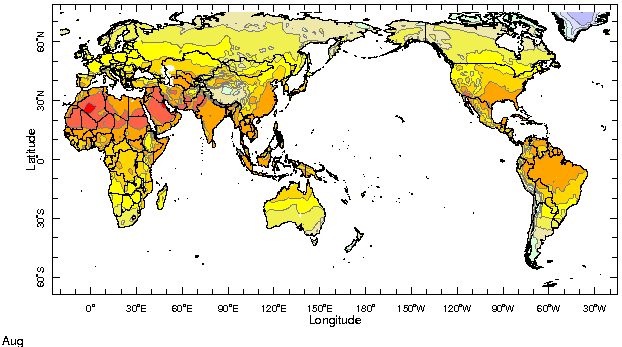
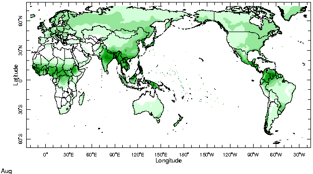
During August, monsoon systems which bring rains to West Africa, South Asia, and southwestern North America reach their northernmost extent. In the Southern Hemisphere midlatitudes, winter conditions begin to wane by month's end.
Monthly Mean Temperature (1961-1990), data from the Climate Research
Unit, University of East Anglia


Monthly Mean Precipitation (1961-1990), data from the Climate Research
Unit, University of East Anglia


Temperatures
Highlights
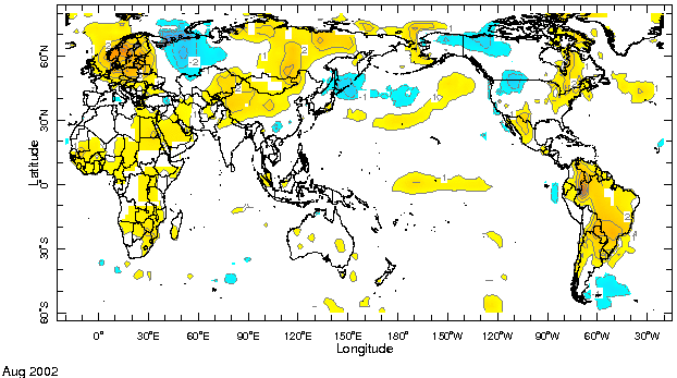
Europe/Western Asia Warmer than average conditions developed across northern and eastern Europe, while cooler than average temperatures were experienced in the region of the Ural Mountains.
Temperature Difference from the 1961-1990 mean, with data
from NCEP Climate Prediction Center, CAMS.


Precipitation
Highlights
Africa Deficient rainfall continued across West Africa in the Sahel, with shortfalls especially pronounced in Senegal and southern sections of Mali and Mauritania. Sporadic rains in the Greater Horn of East Africa were observed in western Ethiopia and southern Sudan.
India Monsoon rains, which were 30% below average across India through the end of July, resumed in the central regions of the sub-continent, while parts of the northwest remained significantly below average.
Australia/Indonesia Precipitation continued to be well below average across much of eastern Australia, with some locations in New South Wales experiencing record deficits. Unusually dry conditions continued across much of Indonesia.
Central America Guatemala, Honduras, and El Salvador are experiencing a second year of deficient rains.
Europe Heavy rains and flooding affected much of central and eastern Europe, including communities in Germany, the Czech Republic, Austria, Russia, Slovakia, and Romania, with areas along the Danube, Elbe, and Vltava Rivers being most affected.
Precipitation Difference from 1961-1990 mean, with data
from NCEP Climate Prediction Center, CAMS-OPI.


Oceanic Conditions
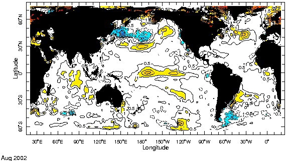
Tropical Pacific: Current conditions represent a developing moderate strength El Nińo as sea surface temperatures (SSTs) across much of the central and eastern equatorial Pacific are currently more than 1 degree C above their long-term average. SSTs were slightly lower than average in the far eastern Pacific near South America during August, however, basin-wide El Nińo conditions are expected to persist through the remainder of 2002 into early 2003. Please see the latest IRI ENSO Update for a detailed summary and outlook.
Tropical Atlantic: Temperatures off of the West African coast north of the equator continued to be colder than average, while higher than average SSTs along the west coast of Southern Africa have dissipated. Warmer than average temperatures off the southeastern coast of South America continued.
Indian Ocean: Surface temperatures continued to be warmer than average in the central and eastern basin.
Mid latitudes: Colder than average surface temperatures continued in a broad west-east band extending from the eastern South Pacific into the southern South Atlantic basin. The south-central Indian Ocean remained cooler than average while a band of colder than average temperatures developed in the western North Atlantic.
Monthly Sea Surface Temperature Difference from the 1950-1979 mean,
with data from the Environmental Modeling Center, NCEP/NOAA.


Contents |
Special |
Impacts |
Climate |
Forecast
|

