| ||||||||||||||||||||||||||||||||||||||||||||||||||||||||||||||||||||||||||||||||||||||||||||||||||||||||||||||||||||||||||||||||||||||||||||||||||||||||||||||||||||||||||||||||||||||||||||||||||||||||||||||||||||||||||||||||||||||||||||||||||||||||||||||||||||||
|
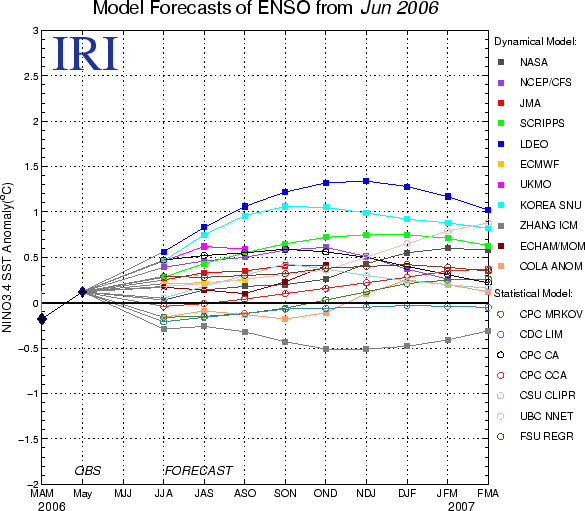
ENSO Quick Look Summary of ENSO Model Forecasts16 June 2006
Note on interpreting model forecastsThe following graph and table show forecasts made by dynamical and statistical models for SST in the Nino 3.4 region for nine overlapping 3-month periods. Note that the expected skills of the models, based on historical performance, are not equal to one another. The skills also generally decrease as the lead time increases. Thirdly, forecasts made at some times of the year generally have higher skill than forecasts made at other times of the year--namely, they are better when made between June and December than when they are made between February and May. Differences among the forecasts of the models reflect both differences in model design, and actual uncertainty in the forecast of the possible future SST scenario. Discussion of current forecastsThe set of dynamical and statistical model forecasts issued during late May and early June 2006 shows a range of possible sea surface temperature conditions for the coming 10 months (June - July - August 2006 through February - March - April 2007). Although several model forecasts indicate the development of weak El Nino conditions over the next several seasons, most of the models predict ENSO-neutral conditions through the end of 2006 and early 2007. At the time of preparing this, the SST observations in the NINO3.4 region are slightly above their average, with an area-averaged anomaly of 0.4 C. Overall, tropical Pacific oceanic and atmospheric features indicate some uncertainty, but generally point to ENSO-neutral conditions during the forthcoming several seasons. Table 1. Forecast SST Anomalies (deg C) in the Nino 3.4 Region
Notes on the dataOnly models producing forecasts on a monthly basis are included. This means that some models whose forecasts appear in the Experimental Long-Lead Forecast Bulletin (produced by COLA) do not appear in the table. The SST anomaly forecasts are for the 3-month periods shown, and are for the Nino 3.4 region (120-170W, 5N-5S). Often, the anomalies are provided directly in a graph or a table by the respective forecasting centers for the Nino 3.4 region. In some cases, however, they are given for 1-month periods, for 3-month periods that skip some of the periods in the above table, and/or only for a region (or regions) other than Nino 3.4. In these cases, the following means are used to obtain the needed anomalies for the table:
As an example of the last case, suppose only the Nino 3 anomaly is provided. The Nino 3.4 anomaly is then obtained by decreasing the Nino 3 anomaly by the factor defined by the ratio of the year-to-year variabilities of Nino 3.4 to the year-to-year variance of Nino 3 SST, for the 3-month season in question. The anomalies shown are those with respect to the base period used to define the normals, which vary among the groups producing model forecasts. They have not been adjusted to anomalies with respect to a common base period. Discrepancies among the climatological SST resulting from differing base periods may be as high as a quarter of a degree C in the worst cases. Forecasters are encouraged to use the standard 1971-2000 period as the base period, or a period not very different from it. | ||||||||||||||||||||||||||||||||||||||||||||||||||||||||||||||||||||||||||||||||||||||||||||||||||||||||||||||||||||||||||||||||||||||||||||||||||||||||||||||||||||||||||||||||||||||||||||||||||||||||||||||||||||||||||||||||||||||||||||||||||||||||||||||||||||||