|
IRI Climate Digest
September 2005
August Global Climate Summary
Climatological Background
During August, monsoon systems which bring rains to West Africa, South Asia, and southwestern North America reach their northernmost extent. In the Southern Hemisphere midlatitudes, winter conditions begin to wane by month's end.
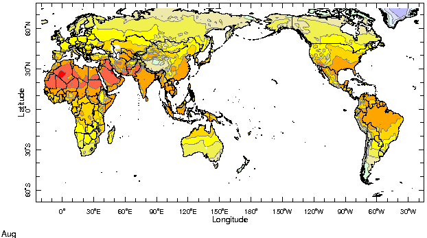
Monthly Mean Temperature (1961-1990), data from the Climate Research
Unit, University of East Anglia

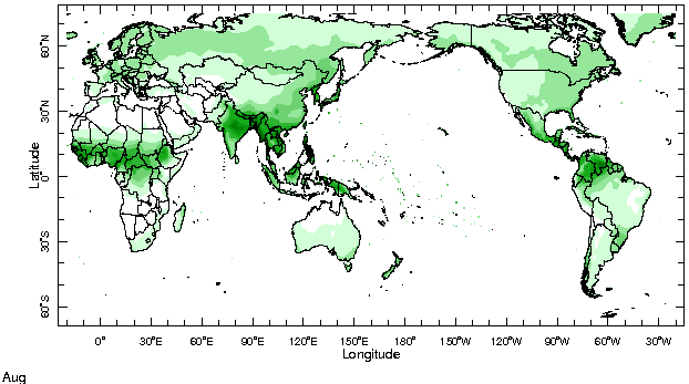
Monthly Mean Precipitation (1961-1990), data from the Climate Research
Unit, University of East Anglia

Temperatures
Highlights
Temperatures were above normal almost globally, the most notable exceptions being north-central Siberia, the regions of central and eastern Europe affected by above-normal rains and flooding, and the Canadian plains east of the Rocky Mountains, where cooler-than-average temperatures have persisted over the past season. At subtropical latitudes of northern and southern Africa positive temperature anomalies, over 2�C above the long-term mean, persisted from July. Temperatures were also 1-2�C above normal along the western North Pacific and North Atlantic rims.
Temperature Difference from the 1961-1990 mean, with data
from NCEP Climate Prediction Center, CAMS.
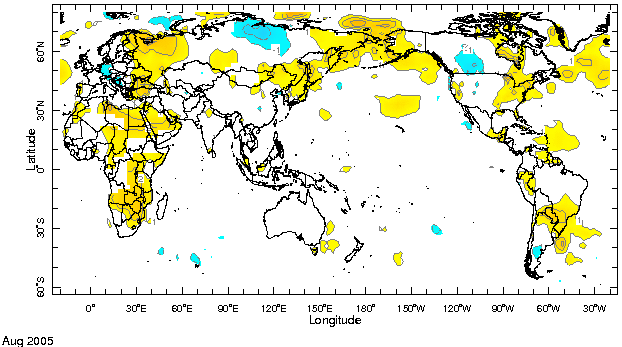

Precipitation
Highlights
Precipitation anomalies were characterized by a lack of coherence at large spatial scales - a clear sign of the absence of a dominant, large-scale source of variability. Above-normal rains persisted in eastern Europe, especially Romania and Bulgaria (related impact report), while the core region of the Indian monsoon experienced below-average precipitation. This was in sharp contrast to July, when the South Asian monsoon had reached record daily totals in Mumbai. In the Northern Hemisphere summer African monsoon region, anomalously dry conditions persisted along the Gulf of Guinea coast, and in the eastern Sahel, while precipitation in the western Sahel hovered around climatological values. In the Caribbean/Central American region, anomalously wet conditions prevailed, consistent with the above-normal sea surface temperatures in the adjacent tropical North Atlantic basin. However, patches of anomalously dry conditions could be noticed along the Caribbean coast of Honduras and Nicaragua. Anomalously wet conditions persisted from the previous month in the Canadian plains east of the Rocky Mountains, while Hurricane Katrina significantly contributed to the above-normal totals in the southeastern US.
Precipitation Difference from 1979-2000 mean, with data
from NCEP Climate Prediction Center, CAMS-OPI.


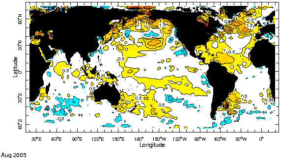
Oceanic Conditions
Sea surface temperature (SST) anomalies in all the tropical oceans were weak - similar in pattern, but reduced in magnitude with respect to the previous month. This was the case for the meridional gradient between an anomalously warm tropical North Atlantic and an anomalously cool eastern equatorial Atlantic, for the warm anomalies all across the tropical Pacific, and for the equatorial Indian Ocean. Warm SST anomalies prevailed at mid to high latitudes of the North Pacific and Atlantic Oceans, in a pattern very similar to that observed a year ago, as well as in the mid latitudes of the South Pacific and Atlantic Oceans.
Monthly Sea Surface Temperature Difference from the 1971-2000 mean,
with data from the Environmental Modeling Center, NCEP/NOAA.

Contents |
Special |
Impacts |
Climate |
Forecast
|
