|
IRI Climate Digest
July 2005
June Global Climate Summary
Climatological Background
In June, the sun's maximum northward location is achieved at 23.6 degrees north. Surface heating of the continents has initiated summer monsoonal systems or northern hemisphere warm season rains. In the southern hemisphere, winter is setting in with fewer daylight hours and cooler temperatures. The southern parts of South Africa, Australia, and South America are now in the path of mid latitude storm tracks.
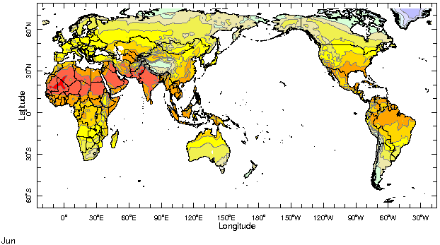
Monthly Mean Temperature (1961-1990), data from the Climate Research
Unit, University of East Anglia

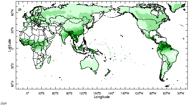
Monthly Mean Precipitation (1961-1990), data from the Climate Research
Unit, University of East Anglia

Temperatures
Highlights
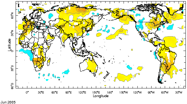
In June, atmospheric temperatures were above normal in most continental regions, with many places observing temperatures in the 90th percentile (June Temperature Percentile Map). This was the case for the southern hemisphere subtropics of Africa and the Americas, the eastern rim of the North Atlantic basin - especially southwestern Europe and northwestern Africa - and northeastern North America. Though not as large in amplitude, anomalies of up to 4°C in peninsular India were indicative of a heatwave in eastern India. In contrast, below-average conditions in eastern Europe and the western US and Canada signaled a marked change from the previous month.
Temperature Difference from the 1961-1990 mean, with data
from NCEP Climate Prediction Center, CAMS.

Precipitation
Highlights
The rainy season in the western Sahel got off to a good start during June, while in the eastern Sahel (Eritrea and the northern portions of Ethiopia) and along the Gulf of Guinea coast, precipitation was deficient. In fact, precipitation was below normal all across the tropical North Atlantic at about 4°N, from the Gulf of Guinea to northern South America, while it was abundant to the north, in the Caribbean Sea - an indication of a northward shift of the Intertropical Convergence Zone (ITCZ). Rainfall was above average in the Gulf of Mexico and southeastern US, and below average in the southwestern US and Mexican central plateau. In South Asia the monsoon was off to a wet start on the Arabian Sea coast of India, especially in the northwest, but not on the Bay of Bengal coast. Precipitation was above average in southern and northeastern China, and below average in the Yangtze river valley, with the region of below-average precipitation extending into Japan as well. In mid-latitudes, precipitation was below average in western Europe - though summer is the dry season there. Central Canada experienced above-normal rainfall during June.
Precipitation Difference from 1979-2000 mean, with data
from NCEP Climate Prediction Center, CAMS-OPI.


Oceanic Conditions
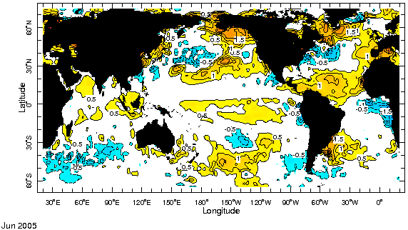
Sea surface temperatures in the extratropics of the northern hemisphere were again warmer than usual, with colder-than-average conditions in the regions of the Kuroshio and Gulf Stream Extensions, similar to one year ago. The equatorial Indian and Pacific Oceans were warmer than usual, while the eastern equatorial Atlantic was markedly cooler than average. The southern extratropical Pacific and Atlantic Oceans were also warmer than usual, while the Indian Ocean south of 30°S was cooler than usual.
Monthly Sea Surface Temperature Difference from the 1971-2000 mean,
with data from the Environmental Modeling Center, NCEP/NOAA.

Contents |
Special |
Impacts |
Climate |
Forecast
|
