IRI
Climate Digest Volume 3, Number 1
January-March Climate Outlook
Date and
Period of Forecast In
January 2000, the IRI
Experimental Forecast Division prepared a Climate Outlook for January-March
2000. Here we provide a subset of the January Net Assessment Forecast.
The complete forecast, which includes global forecasts for April-June 2000,
can be found at http://iri.columbia.edu/climate/forecast/net_asmt/.
UncertaintiesThis
Climate Outlook is dependent on the quality of the SST predictions [link
to Ocean below]. For the tropical Pacific, these predictions can be expected
to provide useful information, but there is some uncertainty concerning
the detailed evolution of SSTs. Spread in global SST predictions
is a source of uncertainty in the Outlook provided here. The procedures,
models, and data used to derive this Climate Outlook may be somewhat different
from those used by National Meteorological Services in particular regions
and may differ from the official forecasts issued in those areas.
Regional
Influences The
current status of seasonal-to-interannual climate forecasting allows prediction
of spatial and temporal averages, and does not fully account for all factors
that influence regional and national climate variability. This Outlook
is relevant only to seasonal time scales and relatively large areas; local
variations should be expected. For further information concerning this
and other guidance products, users are strongly advised to contact their
National Meteorological Services.
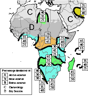
Precipitation
Outlook The Outlook for
January-March 2000 can also be found at http://iri.columbia.edu/climate/forecast/net_asmt/.
Maps
are given showing expected precipitation probabilities in tercile
classes. The maps indicate probabilities that seasonal precipitation will
fall into the wettest third
of the years (top number), the middlethird
of years (middle number) or the driest third of the years (bottom).
An
outlook of climatology "C" (light grey) indicates equal probabilities
in each class; i.e., there is no basis for favoring the forecast of any
particular category.
Areas
marked "D" (dark grey) experience a pronounced dry season during
the forecast period, typically receiving less than 15% of their annual
precipitation or less than 5 cm total during this three-month period.
Boundaries
between sub-regions should be considered transition zones, and their location
considered to be only qualitatively correct.
Africa
The following regions of enhanced
probabilities of precipitation anomalies are indicated:
P.A) slightly enhanced probabilities
of above-normal precipitation over central Libya, north-eastern Niger,
and north-western Chad
P.B) slightly enhanced probabilities
of below-normal precipitation over part of Iran
P.C) slightly enhanced probabilities
of normal precipitation along the
south coast of West Africa between
Ghana and Equatorial Guinea
P.D) enhanced probabilities of
below-normal precipitation over Gabon, Congo, Central African Republic,
the northern half of the Democratic Republic of Congo, and extending eastward
to about 30E
P.E) slightly enhanced probabilities
of normal precipitation over Kenya, southern Ethiopia, most of Uganda,
north-eastern Tanzania, and the far south-eastern part of Sudan
P.F) enhanced probabilities of
normal precipitation over northern and coastal Angola, most of the southern
half of the Democratic Republic of Congo, north-eastern Zambia, most of
Tanzania, the northern half of Malawi, and northern Mozambique
P.G) enhanced probabilities of
above-normal precipitation over the far northern part of Namibia, southern
Angola, most of Zambia, northern Zimbabwe, southern Malawi and central
Mozambique
P.H) slightly enhanced probabilities
of above-normal precipitation over the west coast of Namibia and South
Africa
P.I) slightly enhanced probabilities
of below-normal precipitation over the far south-western part of South
Africa
P.J) enhanced probabilities of
normal precipitation over most of Namibia and South Africa, Botswana, Lesotho,
Swaziland, southern Zimbabwe and southern Mozambique
P.K) enhanced probabilities of
above-normal precipitation over
Madagascar
P.L) enhanced probabilities of
above-normal to normal precipitation over the Seychelles
P.M) slightly enhanced probabilities
of normal precipitation over the Mauritius and Reunion
North and Central America
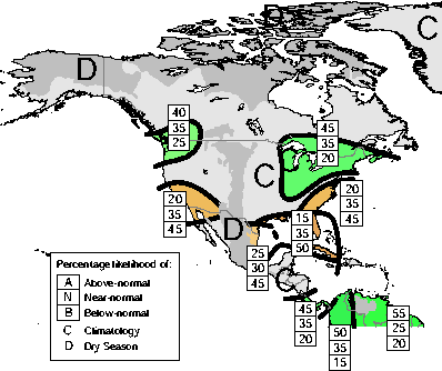 January-March 2000 Precipitation probabilities
 |
The following regions of enhanced probabilities
of precipitation anomalies are indicated:
P.A) slightly
enhanced probabilities of above-normal precipitation over the Pacific Northwest,
covering northern Oregon, Washington, and southern parts of British Columbia
and Alberta
P.B) enhanced probabilities of below-normal
precipitation in a zone over the southwest United States, extending slightly
into northwest Mexico and Baja
P.C) enhanced probabilities of above-normal
precipitation over an area extending over the central/north eastern United
States, east of about 90E from Tennessee, to southeastern Canada and including
the New England States
P.D) enhanced probabilities of below-normal
precipitation of the central Atlantic states of the US, from Georgia through
southern Maryland
P.E) greatly enhanced probabilities of below-normal
precipitation along the Gulf Coast of the United States starting at Texas,
and including all of Florida, Cuba, and the Bahamas. There is a slightly
enhanced risk of the seasonal precipitation being in the extreme below-normal
category over Florida
P.F) enhanced probabilities of below-normal
precipitation over the southern tip of Texas down through central eastern
Mexico
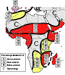
Temperature OutlookThe
Outlook for January-March 2000 can also be found at http://iri.columbia.edu/forecast/net_asmt.
The
temperature map shows expected probabilities that the seasonal temperatures
will fall into the warmest third
of the years (top number), the middle third of the years, or the coldest
third of the years (bottom number).
A
qualitative outlook of climatology "C" (light grey) indicates equal probabilities
in each class i.e.; there is no basis for favoring the forecast of any
particular category.
Boundaries between sub-regions should
be considered transition zones, and their location considered to be only
qualitatively correct.
Africa
The following regions of enhanced
probabilities of temperature anomalies are indicated:
T.A) slightly enhanced probabilities
of above-normal temperatures over the north coasts of Morocco and Algeria,
northern Tunisia, extending northward into southern Europe
T.B) enhanced probabilities of
near-normal to above-normal temperatures over most of Morocco, and the
northern part of Algeria
T.C) greatly enhanced probabilities
of above-normal temperatures over an area extending from southern Mali
into northern Sudan and Djibouti, and into the southern part of the Arabian
peninsula
T.D) greatly enhanced probabilities
of above-normal temperatures over West Africa south of about 10N, extending
along the south-west coast to Senegal, and southward to include most of
Congo
T.E) greatly enhanced probabilities
of above-normal temperatures over Somalia, Djibouti, and the eastern half
of Ethiopia
T.F) enhanced probabilities of
normal temperatures over Kenya, Uganda, Rwanda, Burundi, Tanzania, northern
Zambia and the far northern part of Malawi
T.G) greatly enhanced probabilities
of above-normal temperatures over Mozambique, the eastern half of Zimbabwe,
south-eastern Zambia, and most of Malawi
T.H) enhanced probabilities of
normal temperatures over eastern Angola, western Zambia, Botswana, Lesotho,
and most of South Africa
T.I) greatly enhanced-probabilities
of above-normal temperatures over Madagascar
North and Central America
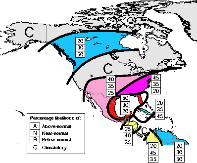 January-March 2000 Temperature Probabilities
 |
The following regions of enhanced
probabilities of temperature anomalies are indicated:
T.A) greatly enhanced probabilities
of below-normal temperatures over a zone extending from the northwest corner
of the United States and the entire west coast of Canada eastward to Hudson
Bay
T.B) slightly enhanced probabilities
of above-normal temperatures over an area extending from the south-western
region of the United States, down through the western half of Mexico and
extending eastward though the central United States
T.C) enhanced probabilities of
above-normal temperatures over the eastern United States
T.D) greatly enhanced probabilities
of above-normal temperatures over the eastern half of Mexico, and the gulf
coast of the United States, including all of Floria
T.E) enhanced probabilities of
below-normal temperatures over Cuba, Jamaica, and the Bahamas
T.F) slightly enhanced probabilities
of near-normal to below-normal temperatures over southern Guatemala, Honduras,
El Salvador and Nicaragua
Ocean Conditions of
relevance in the preparation of this Outlook has been the current weak
La Niña conditions (lower than average sea surface temperatures
(SSTs) in the central equatorial Pacific Ocean) that have been amplifying
through the end of 1999 and are expected to decline slowly through the
forecast period. The SSTs of the western tropical Indian Ocean were assumed
to remain near-normal, and the above-average SSTs of the eastern tropical
Indian Ocean are expected to return to normal during the forecast period.
The forecast of the tropical North Atlantic SSTs suggests a cooling trend
through June 2000.
Methods The
following procedures and information were used to prepare this Climate
Outlook:
-
Coupled ocean-atmosphere model predictions of tropical Pacific SST --
particularly heavy weighting has been given to the NOAA /NCEP, Climate Modeling Branch coupled model
-
Statistical forecasts
of Indian Ocean and Atlantic Ocean sea surface temperature
-
The response of
Atmospheric global circulation model (GCM) predictions to the present and
predicted SST patterns
-
Statistical analyses
-
Appropriate Regional Climate Outlook Forum
consensus guidance.
|