| |||||
IRI Climate Information Digest - February 1999
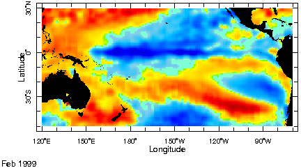
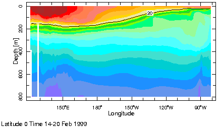
Highlights La Niña conditions continue to characterize the equatorial Pacific from west of 120°W to 160°E. February sea surface temperatures were 1 to 2°C below the average over most of this area with pockets of colder equatorial water. Warmer than average sea surface temperatures have emerged to the east of 120°W and along the immediate Southern American coastal areas. While there has been some concern that these positive sea surface temperature anomalies might be signaling a possible return of El Niño conditions closer examination of oceanic conditions suggest that these anomalies are associated with phenomena other than El Niño. Most notably, the equatorial ocean substructure continues to show a very shallow thermocline to the South American coast (indicated by the dark line on the depth versus longitude temperature analysis on the right). The current configuration of sea surface temperature anomalies highlights some of the differences between El Niño, where the largest magnitude of these anomalies tends to be in the eastern Pacific, and La Niña, where the largest anomalies tend to be in the central Pacific. Current outlooks call for continued La Niña conditions in the central equatorial Pacific with a slow return to near average conditions over the next two seasons. Climate models do not have the capability for predicting the evolution of the phenomenon associated with the relative warm waters along the South American coast. Precipitation Patterns Reports of rainfall in Peru and Ecuador
have also raised fears of a possible return of El Niño this year.
Closer analysis suggests a different physical mechanism. In this case,
La Niña related enhanced Amazonian rainfall appears to be displaced
to the west, giving rise to increased rainfall and some significant flooding
on the western slopes of the Andes. February rainfall amounts of about
30 mm in Piura and 100 mm in Tumbes have been well above average but have
occurred mainly with two episodic rain events and remain well below the
400 mm or more experienced with the El Niño conditions last February.
However, the peak in the annual cycle of coastal waters is near
26°C and occurs in early March, so that the present 2°
positive temperature anomalies along the coast suggest that some
locally enhanced rainfall may be associated with these anomalies along
coastal Peru and Ecuador in March. Elsewhere, topical and subtropical
rainfall patterns are consistent with past La Niña episodes.
These include enhanced rainfall in Australia, Indonesia, Southern Africa,
and Northern Brazil.
|