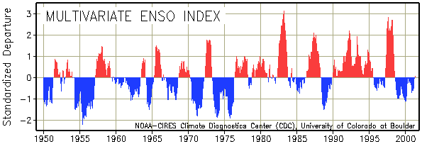
This Index is an attempt to monitor
the coupled oceanic-atmospheric character of ENSO by basing the Multivariate
ENSO Index (MEI) on the main observed variables over the tropical Pacific.
These surface marine observations have been collected and published in
COADS for many years. The MEI can be understood as a weighted average of
the main ENSO features (details) contained in the following six variables:
sea-level pressure, the east-west and north-south components of the surface
wind, SST, surface air temperature, and total amount of cloudiness. The
MEI is extended during the first week of the following month (discussed
on the MEI home page) based on near-real time marine ship and buoy observations
(courtesy of R.W. Reynolds at NCEP) summarized into "COADS-compatible 2-degree"
monthly statistics at CDC. Caution should be exercised when interpreting
the MEI on a month-to-month basis, since the input data for updates are
not as reliable as COADS. Positive values of the MEI represent the warm
ENSO phase (El Niño).
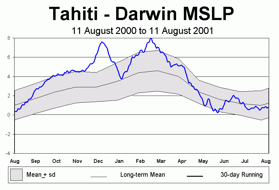
The above timeseries correspond to area averaged sea surface temperature anomalies in the tropical Pacific
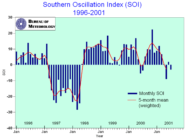
The Southern Oscillation Index (SOI) is calculated from the monthly or seasonal fluctuations in the air pressure difference between Tahiti and Darwin. Sustained negative values of the SOI often indicate El Niño episodes. These negative values are usually accompanied by sustained warming of the central and eastern tropical Pacific Ocean, a decrease in the strength of the Pacific Trade Winds, and a reduction in rainfall over eastern and northern Australia. The most recent strong El Niño was in 1997/98.
Positive values of the SOI are associated with stronger
Pacific trade winds and warmer sea temperatures to the north of Australia,
popularly known as a La Niña episode. Waters in the central and
eastern tropical Pacific Ocean become cooler during this time. Together
these give an increased probability that eastern and northern Australia
will be wetter than normal. The most recent strong La Niña was in
1988/89; a moderate La Niña event occurred in 1998/99, which weakened
back to neutral conditions before reforming for a shorter period in 1999/2000.
This last event finished in Autumn 2000.
Sea surface temperature (SST) anomalies continued to increase
in the central equatorial Pacific during July 2001. Since February 2001
SSTs and SST anomalies have steadily increased in the central equatorial
Pacific Niño 4 region (Fig. 1) rising to their highest levels since
the 1997-98 warm (El Niño) episode. By late July equatorial SST
anomalies between 0.5°C and 1°C were observed between 165°E
and 135°W (Fig. 2). Over the past two years there has been a gradual
expansion of the area of positive equatorial subsurface temperature anomalies
into the central Pacific and a gradual decrease in the strength and area
extent of the negative subsurface temperature anomalies in the eastern
Pacific. This evolution is consistent with the decay of the subsurface
thermal structure that characterizes the mature phase of cold episodes
and the development of conditions usually found just prior to warm episodes.
Accompanying this evolution has been a gradual transition from negative
to positive SST anomalies between 160°E and 130°W. Positive SST
anomalies are likely to continue in the equatorial Pacific during the remainder
of 2001 and into the first half of 2002. This assessment is consistent
with most coupled model and statistical model predictions that indicate
warmer than normal oceanic conditions through early 2002. The impacts that
this warming will have on global temperature and precipitation patterns
depend to a large degree on its intensity. At the moment, there is considerable
spread in the predicted SST anomalies, with most predictions indicating
a weak or moderate warm episode (El Niño) by the end of 2001 and
the beginning of 2002. Weekly updates for SST, 850-hPa wind, OLR and the
equatorial subsurface temperature structure are available on the Climate
Prediction Center homepage at: http://www.cpc.ncep.noaa.gov (Weekly Update).
Forecasts for the evolution of El Niño/La Niña are updated
monthly in CPC's Climate Diagnostics Bulletin Forecast Forum. This ENSO
Diagnostic Discussion, which replaces the ENSO Advisories, will appear
regularly around the 10th of each month on the CPC web site.