|
El Niño and the Southern
Oscillation
El Niño
La Niña
DEFINITION
Near the end of each calendar year ocean surface temperatures
warm along the coasts of Ecuador and northern Peru. Local residents referred
to this seasonal warming as "El Niño", meaning The Child, due to
its appearance around the Christmas season. Every two to seven years a
much stronger warming appears, which is often accompanied by beneficial
rainfall in the arid coastal regions of these two countries. Over time
the term "El Niño" began to be used in reference to these major
warm episodes. In recent decades, it has been recognized that El Niño
is linked with other shifts in global weather patterns in particular to
the Southern Oscillation (SO). The SO denotes the pressure difference in
the tropical Pacific between Darwin and Tahiti.
GENERAL CHARACTERISTICS OF El NIÑO (from
Climate Prediction Center page)
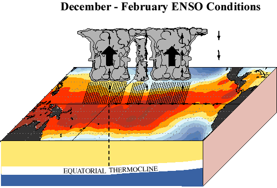
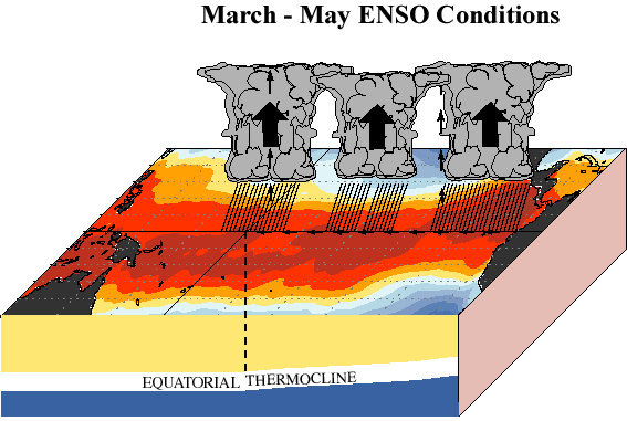
Warm (El Niño)Episodes in the Tropical Pacific
El Niño is closely related to a global atmospheric oscillation
known as the Southern Oscillation (SO). During El Niño episodes
lower than normal pressure is observed over the eastern tropical Pacific
and higher than normal pressure is found over Indonesia and northern Australia.
This pattern of pressure is associated with weaker than normal near-surface
equatorial easterly (east-to-west) winds. These features characterize the
phase of the SO, which is often referred to as an El Niño/Southern
Oscillation (ENSO) episode. During warm (ENSO) episodes the normal patterns
of tropical precipitation and atmospheric circulation become disrupted.
The abnormally warm waters in the equatorial central and eastern Pacific
give rise to enhanced cloudiness and rainfall in that region, especially
during the boreal winter and spring seasons. At the same time, rainfall
is reduced over Indonesia, Malaysia and northern Australia. Thus, the normal
Walker Circulation during winter and spring, which features rising air,
cloudiness and rainfall over the region of Indonesia and the western Pacific,
and sinking air over the equatorial eastern Pacific, becomes weaker than
normal, and for strong warm episodes it may actually reverse. The increased
heating of the tropical atmosphere over the central and eastern Pacific
during warm episodes, affects atmospheric circulation features, such as
the jet streams in the subtropics and in the temperate latitudes of the
winter hemisphere. The jet streams over the eastern Pacific Ocean are stronger
than normal during warm episodes (see seasonal atmospheric circulation
features). Also, during warm episodes extratropical storms and frontal
systems follow paths that are significantly different from normal, resulting
in persistent temperature and precipitation anomalies in many regions.
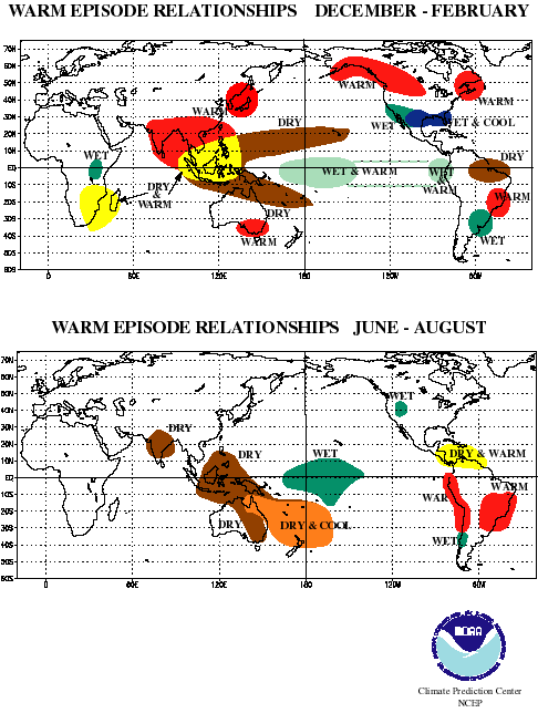
By studying past warm episodes scientists have discovered precipitation
and temperature anomaly patterns that are highly consistent from one episode
to another. Significant departures from normal are shown in the accompanying
figures for the Northern Hemisphere winter and summer seasons. Within the
tropics, the eastward shift of thunderstorm activity from Indonesia into
the central Pacific during warm episodes results in abnormally dry conditions
over northern Australia, Indonesia and the Philippines in both seasons.
Drier than normal conditions are also observed over southeastern Africa
and northern Brazil, during the northern winter season. During the northern
summer season, Indian monsoon rainfall tends to be less than normal, especially
in northwest India where crops are adversely affected. Wetter than normal
conditions during warm episodes are observed along the west coast of tropical
South America, and at subtropical latitudes of North America (Gulf Coast)
and South America (southern Brazil to central Argentina).
During a warm episode winter, mid-latitude low pressure systems
tend to be more vigorous than normal in the region of the eastern North
Pacific. These systems pump abnormally warm air into western Canada, Alaska
and the extreme northern portion of the contiguous United States. Storms
also tend to be more vigorous in the Gulf of Mexico and along the southeast
coast of the United States resulting in wetter than normal conditions in
that region. Since anomaly patterns during cold episodes tend to persist
for several months, accurate long-range forecasts (1 to 3 seasons) are
possible for the regions shown in the accompanying figures. For the latest
information on the status of La Niña, go to ENSO Advisory (issued
when appropriate) or the latest monthly Climate Diagnostics Bulletin. More
technical information on the global patterns of abnormal precipitation
and temperature related to warm episodes in the tropical Pacific can be
found in Ropelewski and Halpert (1987, Mon. Wea. Rev., 115, 1606-1626),
and Halpert and Ropelewski (1992, J. Climate, 5, 577-593). A general description
of a warm (ENSO) episode and its composite evolution can be found in Rasmusson
and Carpenter (1982, Mon. Wea. Rev., 110, 517-528). Upper-tropospheric
circulation features that accompany extreme phases of the Southern Oscillation
are discussed in a paper by Arkin (1982, Mon. Wea. Rev., 110, 1393-1404).
GENERAL CHARACTERISTICS OF
LA NIÑA
Cold (La Niña) Episodes in the Tropical Pacific
At times ocean surface temperatures in the equatorial Pacific
are colder than normal. These cold episodes, sometimes referred to as La
Niña episodes, are characterized by lower than normal pressure over
Indonesia and northern Australia and higher than normal pressure over the
eastern tropical Pacific. This pressure pattern is associated with enhanced
near-surface equatorial easterly winds over the central and eastern equatorial
Pacific. During cold (La Niña) episodes the normal patterns of tropical
precipitation and atmospheric circulation become disrupted. The abnormally
cold waters in the equatorial central give rise to suppressed cloudiness
and rainfall in that region, especially during the Northern Hemisphere
winter and spring seasons. At the same time, rainfall is enhanced over
Indonesia, Malaysia and northern Australia. Thus, the normal Walker Circulation
during winter and spring, which features rising air, cloudiness and rainfall
over the region of Indonesia and the western Pacific, and sinking air over
the equatorial eastern Pacific, becomes stronger than normal. By studying
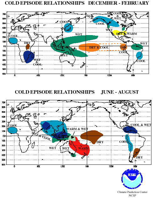
past cold episodes scientists have discovered precipitation and temperature
anomaly patterns that are highly consistent from one episode to another.
Significant departures from normal are shown in the accompanying figures
for the Northern Hemisphere winter and summer seasons. During cold episodes,
the colder than normal ocean temperatures in the equatorial central Pacific
act to inhibit the formation of rain-producing clouds over that region.
Wetter than normal conditions develop farther west over northern Australia,
Indonesia and Malaysia, during the northern winter, and over the Philippines
during the northern summer. Wetter than normal conditions are also observed
over southeastern Africa and northern Brazil, during the northern winter
season. During the northern summer season, the Indian monsoon rainfall
tends to be greater than normal, especially in northwest India. Drier than
normal conditions during cold episodes are observed along the west coast
of tropical South America, and at subtropical latitudes of North America
(Gulf Coast) and South America (southern Brazil to central Argentina) during
their respective winter seasons. Mid-latitude low pressure systems tend
to be weaker than normal in the region of the Gulf of Alaska, during a
cold episode winter. This favors the build-up of colder than normal air
over Alaska and western Canada, which often penetrates into the northern
Great Plains and the western United States. The southeastern United States,
on the other hand, becomes warmer and drier than normal. Since anomaly
patterns during cold episodes tend to persist for several months, accurate
long-range forecasts (1 to 3 seasons) are possible for the regions shown
in the accompanying figures. For the latest information on the status of
La Niña, go to ENSO Advisory (issued when appropriate) or the latest
monthly Climate Diagnostics Bulletin.
More technical information on the global patterns of abnormal
precipitation and temperature related to cold episodes in the tropical
Pacific can be found in Ropelewski and Halpert (1989, J. Climate, 2, 268-284),
and Halpert and Ropelewski (1992, J. Climate, 5, 577-593).
NAME="TABLE">TABLE of Economic IMPACTS
of ENSO 1997
| Location |
Anomaly |
Mayor Social impact |
Costs |
Ecuador & Northern Peru |
Flooding |
600 dead |
$650 million |
| Southern Peru & Western Bolivia |
Drought |
n/a |
$240 million |
| Southern Brazil, Northern Argentina & Eastern Paraguay |
Flooding |
170 dead, 600,000 evacuated |
$3 billion |
| Bolivia |
Flooding |
50 dead, 26,00 homeless |
$300 million |
|