| ||||||||||||||||||||||||||||||||||||||||||||||||||||||||||||||||||||||||||||||||||||||||||||||||||||||||||||||||||||||||||||||||||||||||||||||||||||||||||||||||||||||||||||||||||||||||||||||||||||||||||||||||||||||||||||||||||||||||||||||||||||||||||||||||||||||||||||||||||||||||||||||||||||||||||||||
|
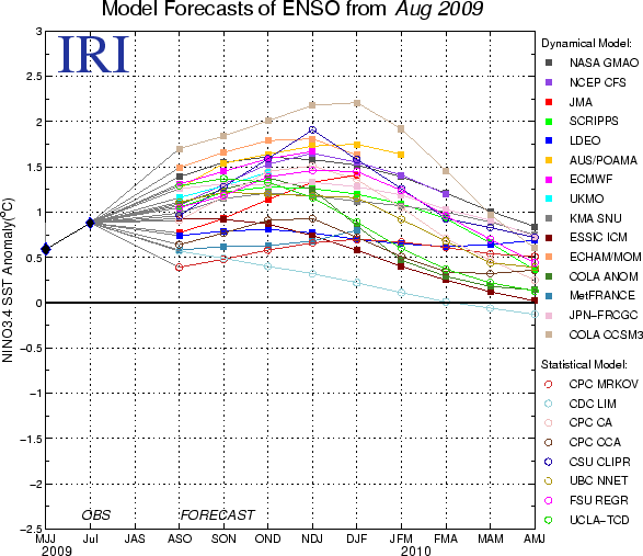
ENSO Quick Look Summary of ENSO Model Forecasts19 August 2009Note on interpreting model forecastsThe following graph and table show forecasts made by dynamical and statistical models for SST in the Nino 3.4 region for nine overlapping 3-month periods. Note that the expected skills of the models, based on historical performance, are not equal to one another. The skills also generally decrease as the lead time increases. Thirdly, forecasts made at some times of the year generally have higher skill than forecasts made at other times of the year--namely, they are better when made between June and December than when they are made between February and May. Differences among the forecasts of the models reflect both differences in model design, and actual uncertainty in the forecast of the possible future SST scenario. Table 1. Forecast SST Anomalies (deg C) in the Nino 3.4 Region
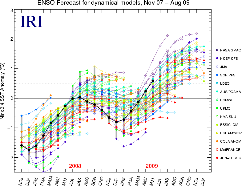
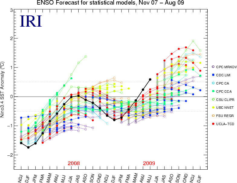
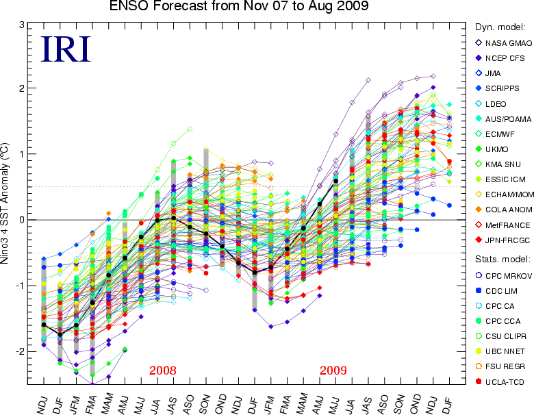
Discussion of current forecastsThe set of dynamical and statistical model forecasts issued during late July and early August 2009 shows a fairly large range of magnitudes of above-average SST, spanning from ENSO-neutral conditions to strong El Nino conditions. The mean forecast calls for a moderate El Nino event, peaking at between 1 and 1.5 degrees C anomaly in the NINO3.4 region during northern autumn 2009. At the time of preparing this, the SST observations in the NINO3.4 region are at a weak El Nino level, with an area-averaged weekly anomaly of 0.7C. Tropical Pacific atmospheric conditions continue to show only weak signs of El Nino so far, including mild westerly wind anomalies in the western Pacific and just slightly enhanced convection near the dateline. The Southern Oscillation Index had become negative during May and June, but recently returned to neutral. Current forecasts and observations indicate that maintenance of weak to moderate El Nino conditions (SST anomaly in the 0.6 to 1.6 range) is the most likely scenario through 2009, with probability of at least weak El Nino approximately about 80 to 85% for the ASO to NDJ seasons. A return to neutral conditions is believed no more than 20% likely during these seasons. Summary of forecasts issued over last 22 monthsThe following plots show the model forecasts issued not only from the current month (as in the plot above), but also from the 21 months previous to this month. The observations are also shown up to the most recently completed 3-month period. The plots allow comparison of plumes from the previous start times, or examination of the forecast behavior of a given model over time. The first plot shows forecasts for dynamical models, the second for statistical models, and the third for all models. For less difficult readability, forecasts are shown to a maximum of only the first five lead times. Below the third plot, we provide a mechanism for highlighting the forecasts of one model at a time against a background of more lightly colored lines for all other models. Individual Model View over last 22 monthsView individual models here. Additional information on ModelsNotes on the dataOnly models producing forecasts on a monthly basis are included. This means that some models whose forecasts appear in the Experimental Long-Lead Forecast Bulletin (produced by COLA) do not appear in the table. The SST anomaly forecasts are for the 3-month periods shown, and are for the Nino 3.4 region (120-170W, 5N-5S). Often, the anomalies are provided directly in a graph or a table by the respective forecasting centers for the Nino 3.4 region. In some cases, however, they are given for 1-month periods, for 3-month periods that skip some of the periods in the above table, and/or only for a region (or regions) other than Nino 3.4. In these cases, the following means are used to obtain the needed anomalies for the table:
The anomalies shown are those with respect to the base period used to define the normals, which vary among the groups producing model forecasts. They have not been adjusted to anomalies with respect to a common base period. Discrepancies among the climatological SST resulting from differing base periods may be as high as a quarter of a degree C in the worst cases. Forecasters are encouraged to use the standard 1971-2000 period as the base period, or a period not very different from it. | ||||||||||||||||||||||||||||||||||||||||||||||||||||||||||||||||||||||||||||||||||||||||||||||||||||||||||||||||||||||||||||||||||||||||||||||||||||||||||||||||||||||||||||||||||||||||||||||||||||||||||||||||||||||||||||||||||||||||||||||||||||||||||||||||||||||||||||||||||||||||||||||||||||||||||||||