April Climate Briefing: El Niño, For Now
From the April climate briefing, given by IRI’s Chief Forecaster Tony Barnston:
Tony Barnston provides an overview of the briefing
Changes from last month’s briefing
A weak El Niño continues in the central Pacific, and the chance that such conditions will persist has risen since last month’s forecast. It hovers around 80% through late summer, although it should be noted that this number only indicates the chance of at least weak El Niño conditions occurring — it does not give information about the strength of the forecasted El Niño.
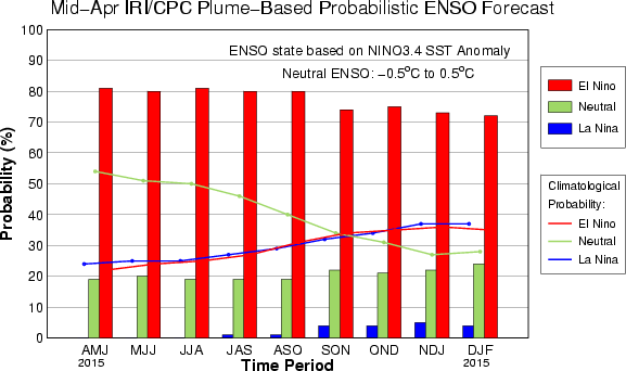
The IRI/CPC probabilistic ENSO forecast issued mid-April 2015. Note that bars indicate likelihood of El Niño occurring, not its potential strength. Unlike the official ENSO forecast issued at the beginning of each month, IRI and CPC issue this updated forecast based solely on model outputs. The official forecast, available at http://1.usa.gov/1j9gA8b, also incorporates human judgement.
The sea-surface temperature anomaly last week in the Nino3.4 region (see second image) was 0.7ºC above average. The SST anomaly in this area is one of the indicators of El Niño conditions, and it has hovered around 0.5ºC, the El Niño threshold, since October. The El Niño advisory issued last month by National Oceanic and Atmospheric Administration’s Climate Prediction Center and IRI is still in effect.

Then and Now
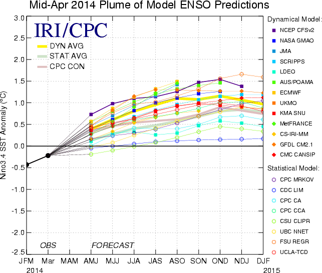
The forecasts at this time last year also called for El Niño development, although El Niño conditions did not fully materialize until the last couple of months. The difference is that this year an El Niño is already in place, with both ocean and atmosphere participating in the coupled climate phenomenon.
Just as last month, it’s hard to tell whether this is the end of one El Niño or the beginning of another. The strong 1997-98 El Niño event got its start around this time of year, but there have been several instances of warm spring SSTs not turning into lasting El Niño conditions. The atmospheric participation we are seeing, however, may be a better indication that El Niño will persist. See the figure on this NOAA ENSO blog post for data.
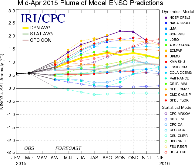
The IRI forecast plumes of April 2014 and April 2015 make for an interesting comparison. Last year, the SST anomaly was beginning from a point of -0.5ºC, whereas the current SSTs are about a degree higher. Last year’s plume was much more narrow, with a total spread of 1.5ºC and most models calling for something in the weak-moderate El Niño range. This year’s forecast has a 2.5ºC difference between the min and max sea-surface temperatures predicted, and some models call for a strong El Niño. In both cases, the dynamical models (average is yellow line) show a warmer forecast than the statistical models (average is green line). This is likely because it is harder for the statistical models to “see through” the spring predictability barrier; some of them do not use subsurface ocean conditions explicitly as a predictor, and most of them use predictors that are an average of the most recent three months, rather than snapshots of the most recent conditions. By averaging over the last three months, the most recent new developments may be largely unaccounted for.
Effects of El Niño on global seasonal forecasts
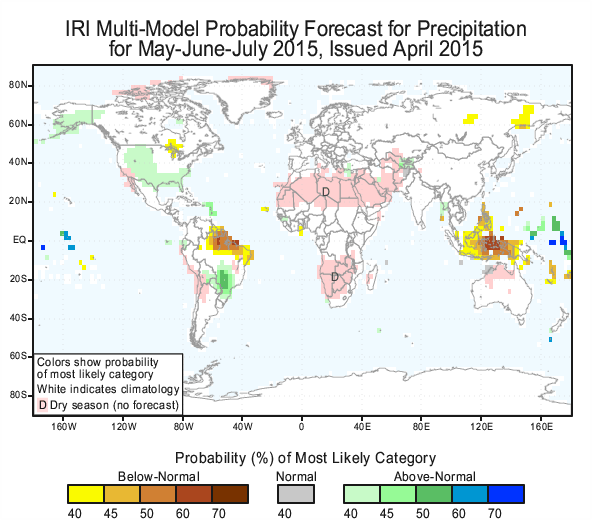 Each month, IRI issues seasonal climate forecasts for the entire globe. These forecasts take into account the latest ENSO SST projections and indicate which areas are more likely to see above or below normal temperatures and rainfall. For the May-July period, the forecast continues to show a strong likelihood of drier-than-normal conditions over Indonesia and northeastern South America (image right). Wetter-than-average conditions continue to be somewhat more likely in the southeastern and parts of the western United States.
Of the sea-surface temperature models that go into the seasonal forecasts, two are predicting a weak El Niño and one is predicting a stronger El Niño. If the models have better agreement following the spring predictability barrier, more teleconnections may be forecasted.
Learn more about El Niño on our ENSO resources page, and sign up here to get notified when the next forecast is issued. In the meantime, check out #IRIforecast or use #ENSOQandA on Twitter to ask your El Niño questions.
You must be logged in to post a comment.