Tutorial 1
IRI Climate Prediction Tutorial 1
What Is the Problem?
- Year to year differences in the timing, intensity and duration of the
rainy/dry and warm/cold seasons can have HUGE impacts on people: on
our prosperity, on our health, and on our environment.
- One of IRI's jobs is to predict when a rainy season might fail or
when flooding or temperature extremes might be likely.
Laying the Foundation for a Solution
- Q: If we can't predict the weather next week, you might ask yourself, why
do we think we can make predictions for next season?
A: Well, we can't predict the weather for next
season, but under some conditions we can to say something useful about
the climate for next season.
- Q: So then what is climate? And what makes it different from weather?
A:
Climate is what you expect,
weather is what you get. The maps below help to illustrate. The panel
on the left shows the precipitation observed on a single day (January 15,
1999) and the panel on the right shows the precipitation for a season
(December-January-February) averaged over many years. If we look
at Southeast Asia for example, we would expect (based on our long term
seasonal average) it to be relatively dry this time of year but on
January 15 what we got was rain.
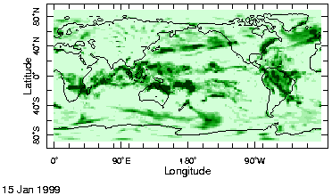
Observed Rain on January 15th, 1999 (Source: NOAA NCEP-NCAR)
|
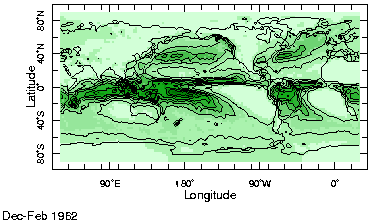
Average precipitation for December-January-February season(Source: NOAA NCEP CPC CAMS_OPI)
|
- Q: If you want to predict the weather tomorrow (without watching the
weather channel) what do you need to know?
A: The most important thing to know for tomorrow's
forecast is today's weather (for example, temperature, pressure,
winds), in as much detail as possible.
- Q: If you want to predict the climate next season (without looking at IRI
forecasts) what do you think you'd need to know?
A: The things we need to know for next season's
forecast are things that affect the atmosphere and change slowly,
like the temperature of the ocean. Ocean temperatures change
relatively slowly and can be very different from one year to the next,
especially when there is an El Niño. You can see ocean or "sea
surface" temperature changes in our
Maproom.
- Q: How is El Niño important?
A: El Niño involves changes in sea surface
temperatures over large areas of the tropical Pacific. It's associated
with year-to-year variations in the character of the seasons.
You can read more about how El Niñoand its sister La Niña affect seasonal patterns all over the globe here. There are other
things that are related to
year-to-year variations in the seasons, too. The North Atlantic
Oscillation is a pattern in surface pressure that can shift rainfall
and temperature patterns over eastern North America and Europe.
What Is the IRI Doing?
- With a knowledge of current sea surface temperatures in the tropical
ocean basins, and model predictions of how the oceans will likely
evolve during the next several months, we use numerical models of the
atmosphere to predict mean seasonal patterns of temperature and
rainfall. But because the atmosphere is a chaotic system, small
changes in the current conditions can result in big differences in
the seasonal patterns the model predicts. So, a single prediction
does not tell the whole story. Each prediction is just one
possible outcome. We deal with this problem by doing a number of
predictions. The combination of several of these predictions is our
best estimate of the next season's mean climate.
- By combining predictions from several different computer models, the
IRI
Net Assessment Forecast provides the probability of above-normal, normal, and below-normal precipitation or temperature.
- The IRI Net Assessment forecasts are only the beginning of what IRI is
doing. To maximize the utility of seasonal forecasts, we are also
developing a variety of monitoring and applications tools for
the global community so that we may be better prepared for the
variations that climate dishes out.
To top
Back
|