The IRI has prepared this Climate Outlook for Europe for April -
September 2000. Of relevance in the preparation of this Outlook has been
the current
La Ni˝a conditions (lower than average sea-surface temperatures
(SSTs) in the central equatorial Pacific Ocean) that had been amplifying
through the end of 1999. Thus, weakening La Ni˝a conditions are in
effect for the first season of the forecast,
April-May-June 2000, and a return to near-normal conditions is
expected for the second forecast season,
July-August-September 2000. The SSTs of the tropical Indian Ocean
were assumed to remain near-normal. The forecast of tropical North
Atlantic SSTs suggests a cooling trend through June 2000.
METHODS -
This Outlook was prepared using the following procedures and
information:
A) Coupled ocean-atmosphere model predictions of tropical Pacific SST
covering the forecast period. Particularly heavy weighting has been
given to predictions from the coupled model operated by the NOAA
National Centers for Environmental Prediction, Climate Modeling Branch.
This model suggests a rapid weakening of La Ni˝a conditions and a return
to near-average conditions by the middle of 2000. The end of La Nina
conditions is consistent with some, but not all, numerical and
statistical forecasts of central and eastern Pacific SSTs.
B) Forecasts of the tropical Indian and Atlantic oceans using
statistical models developed by the IRI and CPTEC respectively.
C) Global atmospheric circulation model (GCM) predictions of the
atmospheric response to the present and predicted sea-surface
temperature patterns.
The procedures, models, and data used to derive this Climate Outlook may
be somewhat different from those used by the national meteorological
services in the region. Thus, this product may differ from the official
forecasts issued in those areas. The Climate Outlook for April -
September 2000 is dependent on the quality of the SST predictions. For
the tropical Pacific, these predictions can be expected to provide
useful information, but there is some uncertainty concerning the
evolution of SSTs. Spread in global SST predictions is a source of
uncertainty in the Outlook provided here.
It is stressed that the current status of seasonal-to-interannual
climate forecasting allows prediction of spatial and temporal averages,
and does not fully account for all factors that influence regional and
national climate variability. This Outlook is relevant only to seasonal
time scales and relatively large areas; local variations should be
expected. For further information concerning this and other guidance
products, users are strongly advised to contact their National
Meteorological Services.
OUTLOOK -
This Outlook covers two seasons: April - June 2000 and July - September
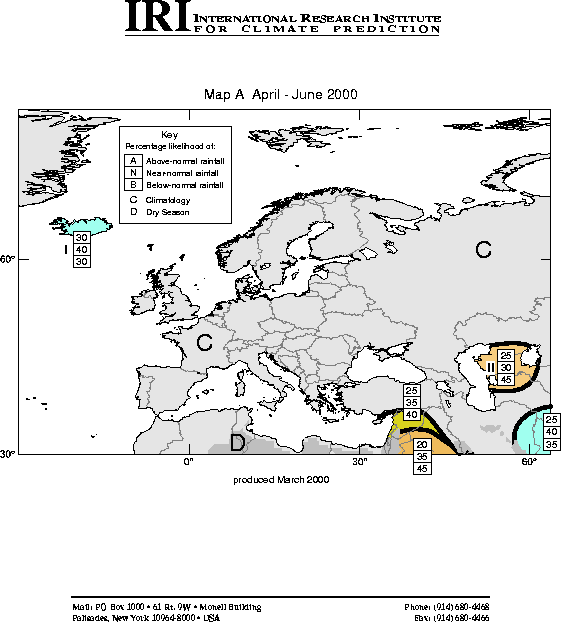
2000. Maps are given showing tercile probabilities of precipitation and
temperature. The maps for precipitation indicate the probabilities that
the seasonal precipitation will fall into the wettest third of the years
within the 1961-90 period (top number), the middle third of the years
(middle number), or the driest third of the years (bottom number). A
qualitative outlook of climatology ("C") indicates that there is no
basis for favoring any particular category. Areas that are marked by "D"
represent regions experiencing their dry season (less than 15% of annual
precipitation) and for which less than 5cm of precipitation typically
occurs over the season. Otherwise, for example, in the case of Iceland
in April - June 2000
(Map B), there is a
30% probability that the precipitation will be in the wettest third of
the years, a 40% chance it will be in the near-normal third of the
years, and a 30% chance that the precipitation will be in the driest
third of the years.
An additional
precipitation map
is provided for the first season indicating probabilities for extreme
precipitation anomalies. Extremes are defined as anomalies that fall
within the top and bottom 15th percentile of the observed records.
Climatologically, there is a 15% probability of being within the
extremely wet category, and a 15% probability of being within the
extremely dry category, leaving a 70% probability that the precipitation
will not be extreme. The maps indicate areas of risk of extreme low or
high precipitation totals. Three levels of increased risk are defined:
slightly enhanced risk, enhanced risk, and greatly enhanced risk. For
slightly enhanced risk, there is a 25-40% probability that precipitation
will be within the indicated extreme, i.e. wet or dry. This represents
an approximate doubling of the climatological risk. For enhanced risk,
there is a 40-50% probability that precipitation will be within the
indicated extreme. This represents an approximate tripling of the
climatological risk. For greatly enhanced risk, the probability that
precipitation will be within the indicated extreme exceeds 50%, i.e. the
indicated extreme is the most likely outcome.
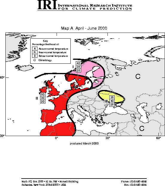
Maps of temperature show expected probabilities that the seasonal
temperatures will fall into the warmest third of the years, the middle
third of the years, or the coldest third of the years
(Map A). The
numbers for each region on the temperature maps indicate the
probabilities of temperatures to fall in each of the three categories,
above-, near-, and below-normal.
Boundaries between sub-regions should be considered as transition zones,
and their location considered to be only qualitatively correct.
April - June 2000:
PRECIPITATION
The following regions of enhanced probabilities of precipitation
anomalies are indicated:
Region I) slightly enhanced probabilities of near-normal precipitation
over Iceland;
Region II) enhanced probabilities of below-normal precipitation over
western parts of Kazakhstan, Uzbekistan and Turkmenistan;
TEMPERATURE
The following regions of enhanced probabilities of temperature anomalies
are indicated:
Region I) strongly enhanced probabilities of above-normal temperatures
over most of western Europe, including the United Kingdom, and extending
from Portugal to southern Norway and Sweden;
Region II) slightly enhanced probabilities of above-normal temperatures
over most of Norway, Sweden, and southwestern Finland;
Region III) slightly enhanced probabilities of near-normal to
above-normal temperatures over most of Ukraine and southern Belarus;
July - September 2000:
PRECIPITATION
The following regions of enhanced probabilities of precipitation
anomalies are indicated:
Region V) slightly enhanced probabilities of below-normal precipitation
over southern Europe from the Mediterranean coast of Spain to Greece,
including most of Italy;
TEMPERATURE
The following region of enhanced probabilities of temperature anomalies
is indicated:
Region VI) enhanced probabilities of above-normal temperatures over the
United Kingdom;
Region VII) slightly enhanced probabilities of below-normal temperatures
over much of Scandanavia;
Region VIII) slightly enhanced probabilities of above-normal
temperatures over Poland, Belarus, and western Russia;
Region IX) slightly enhanced probabilities of near-normal to
above-normal temperatures over southern parts of Portugal and Spain;

![[key]](/climate/forecast/images/key.jpg)