Climate Outlook - Rainfall & Temperature
ASIA April - September 1998
The IRI Experimental Forecast Division has prepared this Climate Outlook for Asia for
April - September 1998. Of
relevance in the preparation of this Outlook has been the strong El Nińo episode now
subsiding in the tropical Pacific,
and the expectation that warm El Nińo conditions will persist for the next few months.
Also relevant to this outlook
are the warm sea-surface temperature (SST) anomalies in the Indian ocean.
METHODS -
This Outlook was prepared using the following procedures and information:
A) Coupled ocean-atmosphere model predictions of tropical Pacific SST
covering the forecast period. Particularly heavy weighting has been given to predictions from
the coupled model operated by the
NOAA National Centers for Environmental Prediction, Climate Modeling Branch. This model suggests that warm
anomalies will persist in the tropical Pacific through the forecast period.
B) Statistical predictions of the tropical Indian and Atlantic SST's.
C) Global atmospheric circulation model (GCM) predictions of the atmospheric response to the present and
predicted SST patterns.
D) Statistical analyses of the observed climate system over Asia.
E) Additional information from the
Regional Climate Outlook Forum convened in Bangkok on Feb. 2, 1998.
The procedures, models, and data used to derive this Climate Outlook may be somewhat different from those used by
the national meteorological services in Asia. Thus, this product may differ from the official forecasts issued in those
areas. This Outlook has been prepared in the time available, using all information that was reasonably accessible.
Inclusion of other climate information and guidance requires further arrangements. The IRI is engaged in establishing
such collaborative arrangements with the goal of improving its capability to provide the best and most complete glo-
bal climate guidance. The Climate Outlook for April-September is dependent on the quality of the SST predictions.
For the tropical Pacific, these predictions can be expected to provide useful information but there is considerable
spread in coupled model predictions concerning the evolution of SSTs. This spread in predictions is a primary source
of uncertainty in the Outlook provided here, which assumes that tropical Pacific SSTs will continue to decline at a
modest rate. Also, it is known that the Indian ocean SSTs may play some role in modulating rainfall changes over
parts of Asia. Thus, the uncertainties in Indian ocean SST values during the forecast period may lead to additional
uncertainty over some parts of Asia.
It is also stressed that the current status of seasonal-to-interannual climate forecasting allows prediction of spatial and
temporal averages, and does not fully account for all factors that influence regional and national climate variability.
This Outlook is relevant only to seasonal time scales and relatively large areas; local variations should be expected.
For further information concerning this and other guidance products, users are strongly advised to contact
their National Meteorological Services.
OUTLOOK -
This Outlook covers two seasons: April-June 1998 and July-September.
Maps are given showing expected
probabilities of precipitation. The maps indicate the probabilities that the seasonal
precipitation will fall into the wettest third of the years (top number), the middle
third of the years (middle number), or the driest third of the years (bottom number).
An additional map is provided for the first season indicating probabilities for extreme precipitation
anomalies. Extremes are defined as anomalies that fall within the top and bottom 15th percentile of the observed
records. Maps of temperature show expected probabilities that the seasonal temperatures will fall into the warmest
third of the years, the middle third of the years, or the coldest third of the years. A qualitative outlook of climatology
("C") indicates that there is no basis for favoring any particular category. Otherwise, for example, in the case of India
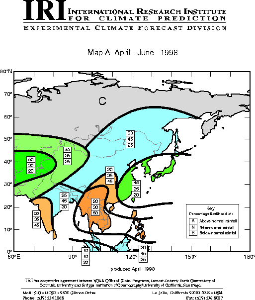
in April-June 1998 (Map A), there is a 20% probability that the precipitation will be in the wettest third of the years,
a 35% chance it will be in the near-normal third of the years, and a 45% chance that the precipitation will be in the
driest third of the years. The numbers for each region on temperature maps indicate the probabilities of temperatures
to fall in each of the three categories, above-, near-, and below-normal. Boundaries between sub-regions should be
considered as transition zones, and their location considered to be only qualitatively correct.
Boundaries between sub-regions should be considered as transition zones, and their location
considered to be only qualitatively correct.
April-June 1998
PRECIPITATION
The map is dominated by the following main regions of enhanced probabilities of precipitation anomalies:
P.A) The region of slightly elevated probabilities for above-normal precipitation over the south-west part of Asia,
Higher probabilities for above normal rainfall are evident over far western China, northern Pakistan, Afghanistan and
southern Kazakhstan. Part of this region has also the slightly enhanced probability for having
the extreme amount of precipitation during this season.
See map.
P.B) The enhance probabilities for the near-normal precipitation over most of the central part of the continent.
P.C) Enhancement of probabilities for above-normal precipitation over the east coast of China, South Korea and
Japan. The region over the east coast of China has also the slightly enhanced probability for having the extreme
amount of precipitation during this season.
See map.
P.D) Enhanced probability for the below-normal precipitation over the Thailand, Cambodia,
Laos, Vietnam and central part of the southern-most China. This region is also shown on the
extreme map for this season as a region with the
enhanced probabilities for the driest 15% precipitation.
See map.
P.E.) The Enhanced probability for the below-normal precipitation over south-west India. This region also has an
enhanced probability of falling into the driest 15% category.
See map.
TEMPERATURE
The main features of the pattern of probabilities for temperature field are:
T.A) Highly enhanced probabilities for the above-normal temperatures over India and southern-most parts of China.
T.B) Enhanced probabilities for warmer temperatures over the southern part of Japan.
T.C) Slightly enhanced probabilities for near-normal temperatures over the northern part of the east coast of China,
western parts of Mongolia and Russia.
July-September 1998:
PRECIPITATION
The map is dominated by the following main regions of enhanced probabilities of rainfall anomalies:
P.i) Slightly enhanced probabilities for the below-normal rainfall over northern half of India,
eastern part of the Pakistan and south-western parts of China.
P.ii) Enhanced probabilities for above-normal precipitation over Thailand, Laos, Vietnam and Cambodia.
P.iii) Slightly enhanced probabilities for below-normal rainfall over northern part of the east coast of China, Korea,
western parts of Mongolia and Russia.
TEMPERATURE
The pattern of probabilities somewhat resembles that for April-June. The main features of this season are as follows:
T.i) Highly enhanced probabilities for the above-normal temperatures over India and southern-most parts of China.
T.ii) Enhanced probabilities for warmer temperatures over the southern part of Japan
T.iii) Slightly enhanced probabilities for below-normal temperatures over the north-eastern part of China, western
parts of Mongolia and Russia.
Cutoffs and Max/Min
extremes for AMJ and JAS.
![[key]](/climate/forecast/images/key.jpg)
To top Back
|
