Back to January 2002 digest
Northeast Brazil's Ceara State Tests High Resolution
Forecast
The state of Ceara's weather and climate institute, FUNCEME,
in collaboration with the IRI, have produced the first experimental
seasonal forecast for the Northeast region using a dynamical downscaling
prediction system.
The prediction system
This prediction system, developed for the northeast
region of Brazil by scientists at FUNCEME and climate
research specialists at the
IRI, is comprised of the ECHAM4.5 AGCM (T42) and the
NCEP Regional Spectral
Model version 97 (RSM97) with horizontal resolution of
60 km. IRI global
climate forecasts (i.e., ECHAM4.5 forecasts) are used
to drive the NCEP
RSM97 to produce high resolution climate forecasts for
northeast Brazil. A
number of statistical tools are developed to correct
the systematic and
conditional biases of the model forecasts.
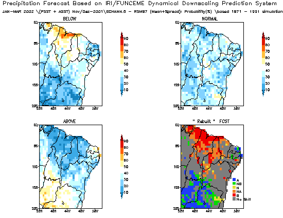
The maps above show experimental dynamically downscaled
forecast result,
which is but one of a number of tools used in generating
the final product of a
consensus seasonal forecast.
The probabilities (as defined
by the vertical colorbar) are given for each of three
categories
("Above Normal", "Near Normal", "Below Normal"), based
the model's past
performance with respect to the observations when predicting
that category.
The information given in the "Above", "Normal", and "Below"
maps is then
combined into a "Re-built Forecast" (see the lower left
panel). This "Re-built Forecast"
gives the most likely qualitative forecast. There are
5 categories for the "Re-built Forecast":
Above (A), Not Below (NB), Normal (N), Not Above (NA),
and Below (B).
The maps above show or the upcoming rainy season (i.e., Jan-Feb-Mar
2002),
"Below" category over Marajo Island, and the coast of Para, Maranhao,
and Piaui,
"Above" category over States of Goias and Minas Geais, and "Not Above"
category
along the coast of Ceara. This is an experimental system, and these
results are
used in conjunction with other tools to create the final forecast,
which is discussed below.
Climate variability in the Northeast
Northeast Brazil has a history of crippling droughts
and a significant
population which relies on rain-fed agriculture.
A single rainy season from February-May provides much
needed
moisture for this semi-arid region, which receives on
average less
than 1000 mm of rainfall annualy. Rainfall is largely
dependent on the
southward movement of a band of rainfall across the Atlantic
Ocean
which follows the warm surface ocean temperatures in
late
austral summer. During years when the warm ocean
temperatures
remain too far north, or alternatively when a strong
El Nino shifts the
tropical circulation, the rainfall band does not reach
far enough
south to provide sufficient rains for the Northeast.
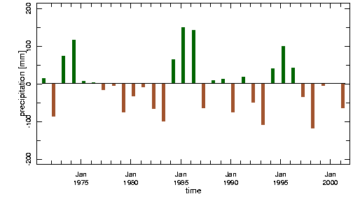
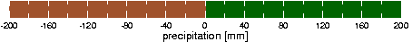
This figure shows Northeast Brazil Feb-May rainfall
anomalies for the period
1971-2001, based on monthly station rainfall from
Fortaleza and Quixeramobim, with climatological base period 1971-2000.
The Recent Past
A severe drought resulted from the 1997/98 El Nino throughout
the
region. However in the three years since, near
average rains were
beneficial in replenishing aquifers and reserviors in
1999 and 2000,
while last year was again somewhat dry. Current
reservior levels in
the Northeast are reported to be near 25% of capacity.
The Seasonal Forecast
For the upcoming February-May rainy season the FUNCEME
forecast, which is based on a number of tools including
the
experimental downscaling system,
calls for a greater likelihood for normal rains.
This is consistent with the forecast from CPTEC
and also from the IRI.
To top
Back to January 2002 digest
|
