| ||||
IRI Climate Information Digest - August 1998
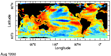
Atlantic Hurricane Activity - After virtually no significant Atlantic tropical cyclone activity early in the season, August witnessed five storms, Alex, Bonnie, Charley and Daniel and, on the last day of the month, Earl. Hurricanes Bonnie and Daniel and tropical storm Charley influenced North American rainfall. Though Charley was the weakest of these storms it had the largest impact with a landfall and local flooding in Texas. The increased Atlantic tropical storm activity is consistent with the developing La Niña conditions which has been linked to enhanced tropical storms in empirical studies. Mid Latitude Precipitation - Heavy rains continued in several areas of northern and central China, Korea, and Japan. During the month, rains along the Yangtse River valley in China expanded into the North China Plain accompanied by widespread flooding. In Japan, Typhoon Rex added to the heavy rainfall over parts of country at the end of the month. Although these large rainfall events occurred during the evolution of La Niña conditions there have been no studies showing strong links between summertime rainfall over the mid latitudes of Asia and La Niña. Global Monsoon Rainfall - August, generally the rainiest month of the Sahelian Africa rainy season, was even wetter than average for most locations from Senegal through Chad. August rainfall excess generally made up for slight to moderate deficits experienced in July. In Southern Asia, ample monsoon rains characterized most of India with excessive amounts associated with flooding in Bangladesh. The North American monsoon system showed signs of recovery from a poor start but dry conditions continued to afflict regions to the east. Global record high temperatures continue - Much above average temperatures were experienced over large portions of the major land areas of the world to result in yet another month of record high global temperature. Extremely warm weather in parts of Northern Africa, Southern Europe, Southern Asia and North America contributed to a record for August. Unless there is unprecedented cooling over the remainder of the year it is expected that 1998 will be the warmest year in the instrumental record.
Forecasts - for temperature and precipitation
|